1954 Ivan Selan Topographical View Map the Julian Alps, Lake Bled, Slovenia
JulijskeAlpeBled-ivanselan-1954$550.00


Title
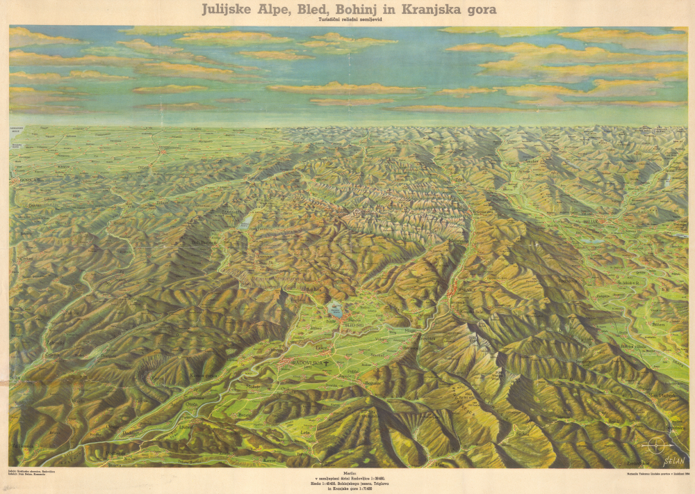
Julijske Alpe, Bled, Bohinj in Kranjska gora Turistični reliefni zemljevid.
1954 (undated) 25.5 x 36 in (64.77 x 91.44 cm)
1954 (undated) 25.5 x 36 in (64.77 x 91.44 cm)
Description
This is a spectacular 1954 Ivan Selan map view of the Julian Alps of the Upper Carniolan region of northwestern Slovenia, made by Slovenia's most prominent and controversial 20th-century cartographer.
A Closer Look
Centered on Lake Bled, coverage is oriented to the west and covers from Gorica to Trebinja and from Tribiz to Kovor. Topography is illustrated pictorially with towns illustrated as small clusters of red-roofed homes. Major roads are indicated, as are rail lines, and the airport at Radovljica. The scale at the latitude of Radovljica is 1:38,460; at Bled, 1:45,455; and for Lake Bohinj, Triglav, and Kranjska Gora, 1:71,430.Lake Bled and the Julian Alps
Lake Bled, nestled in the Julian Alps or Juylijske Alpe of northwestern Slovenia, is an iconic natural landmark. Surrounded by forested hills and overlooked by Bled Castle perched atop a nearby cliff, the lake is famed for its emerald-green waters and the picturesque island at its center, home to the Church of the Assumption. The Julian Alps, part of the southern Limestone Alps, provide a dramatic alpine backdrop and are renowned for their rugged peaks, deep valleys, and rich biodiversity. Together, Lake Bled and the Julian Alps form a stunning landscape that attracts visitors year-round for hiking, boating, and cultural tourism, serving as a gateway to the Triglav National Park and the broader Gorenjska region.Publication History and Census
This map was created by Ivan Selan in collaboration with artist Ludvik Juhant (Žgajnarjev). It was printed by the Ljudska Pravica Printing House in Ljubljana in 1954. OCLC identifies some 7 holdings. The view is scarce to the market.Cartographer
Ivan Selan (Johan Selan, Bazelnu; November 18, 1902 - September 29, 1981) was a Slovenian self-taught cartographer, artist, and counterfeiter active in the mid-20th century. He was born into a farming family in Savelji, not far from Ljubljana. He had a staggering 28 siblings, 11 of whom died in infancy, and 17 of whom grew to adulthood. He never expressed great interest in agriculture, instead being drawn to books and sketching. Despite a professed lack of interest in farming, at 14, he was designated heir to the family farm of Šimnov, near Suhadole. As he matured, he kept his money in the Peskov Savings Bank of Ljubljana, a fateful choice. The bank went bankrupt in a corruption scandal. Frustrated with the dire setback, Selan turned to his artistic talents to recoup and began rampantly counterfeiting money. Although his counterfeiting was exposed, instead of being convicted, he became famous. He was acquitted in the regional court and then invited to work as an engraver at the Military Geographical Institute in Belgrade. There, he mastered mapmaking and topographical rendering. A year later, he returned to his family farm, where he took additional work making local maps on commission. Despite considerable success, he was again involved with counterfeiting, this time apparently without his knowledge. (He was told that he was making game currency.) This time, he was convicted and served 7 months of hard labor. During World War II (1939 - 1945), he repeatedly ran afoul of occupying German authorities, who accused him, without evidence (though he was almost certainly guilty) of collaborating with the Partisans by providing maps showing German positions and supply lines. He also advocated that Slovenian territory historically extended north of the Danube nearly to Vienna. Following the war, he was able to fully dedicate himself to cartographic pursuits, producing numerous maps for private commissions, government agencies, schools, and tourism. Selen produced maps of all parts of the Balkans, including Slovenia, Croatia, Serbia, Macedonia, Montenegro, and Bosnia and Herzegovina. Selen died still at work on his maps in 1981. For this short summary, we are indebted to Marko Žerovnik's comprehensive biography Ivan Selan Od ponarejanja denarja do slavnega kartografa. More by this mapmaker...
Condition
Good. Some wear on old fold lines, with slight infill at a few fold intersections. Closed tear extending from lower left about 6 inches into the map.
References
Žerovnik, Marko, Ivan Selan Od ponarejanja denarja do slavnega kartografa, Figure 105, page 151.