This item has been sold, but you can get on the Waitlist to be notified if another example becomes available, or purchase a digital scan.
1859 Emrik and Binger Satarical Map of Europe
KaartvanEuropa1859-emrikbinger-1859$925.00

Title
Kaart van Europa 1859.
1859 (dated) 9 x 11 in (22.86 x 27.94 cm) 1 : 15568000
1859 (dated) 9 x 11 in (22.86 x 27.94 cm) 1 : 15568000
Description
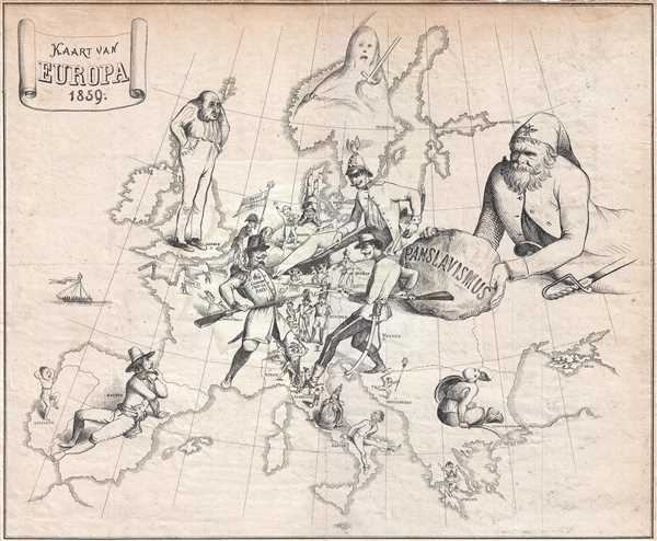
This extremely rare Dutch satirical map by Emrik and Binger illustrates the European situation in 1859 during the Franco-Austrian War. This is one of the earliest known maps to use cartoon imagery to express political satire. Unlike later satirical maps in the spirit of Fred Rose, where the map itself takes the form people and caricatures, here the power figures themselves loom large, standing on the map as if on a great continental game board.
Understanding the Allegory
The political powers of Europe are here represented by their monarchs, priests, and officials. French Emperor Napoleon III and Austrian Emperor Franz Josef, bayoneted rifles ready, engage one another astride the battleground of Northern Italy, then in the midst of the Second War of Italian Independence or Franco-Austrian War. A very youthful Otto von Bismark looks on with eager interest, weapons at the ready, restraining Napoleon III with his foot. In Russia, the Roman Catholic priest Juraj Križanić pushes the idea, symbolized by a great boulder, of Pan-Slavism, a cultural and social movement promoting the union of all Slavic peoples. The size of the figure suggests threat, and the boulder, a great rolling danger is poised to overtake Western Europe which, unawares, focuses on its own internal conflicts. The Ottomans on the other hand are very much aware of the potential risks of Slavic unification and look on fearfully. England, symbolized by a caricature of Edward Smith-Stanley, 14th Earl of Derby, then Prime Minister, watches the conflicts in a curmudgeonly fashion, hands deep in his pockets, indicative of policies aimed at building British power through financial strength and avoiding war at all costsPublication History and Census
This map was published by Emrik and Binger and engraved by J. J. van Brederode. It is extremely rare with Worldcat identifying only a single other example in the British Library at St. Pancras.CartographerS
Emrik & Binger (fl. 1857 - 1927) was a Dutch lithography firm based in Haarlem. The firm was founded by Charles Binger (February 25, 1830 - February 14, 1916) and David Ozer Emrik (May 23, 1809 - December 27, 1883) in 1857. The older Emrik handled the administrative and financial aspects of the firm while Binger focues on the technical side and production. Binger married Emrik's daughter, Jeanette, further binding the two partners. Their earliest known work is a business card dating to 1858. In the early 1860s they began to embrace the new science of photography and won several awards for their work at various expositions and were highly successful. Emrik died in December of 1883. Charles Binger continued to manage the firm on his own, but passed the firm's management on to his son Maurice, and the sons of David Emrik, Orest David Herman and David, in 1896. The firm continued to operate until about 1927. More by this mapmaker...
James Johannes van Brederode (1847 - 1883) was a Dutch bookseller, printer, and engraver active in Haarlem during the second half of the 19th century. In cartographic circles he is best known of his work on satirical maps, including a Dutch edition of the Fred Rose 'Octopus Map' and a scarce satirical map entitled 'Kaart van Europa 1859.' Learn More...
Condition
Very good. Narrow margins all around. Some soiling
References
OCLC 778252193.