This item has been sold, but you can get on the Waitlist to be notified if another example becomes available, or purchase a digital scan.
1939 Fisher Map of the Border Lakes (Rainy Lake, Kabetogama Lake) Minnesota
KabetogamaRainy-fisher-1939$75.00

Title
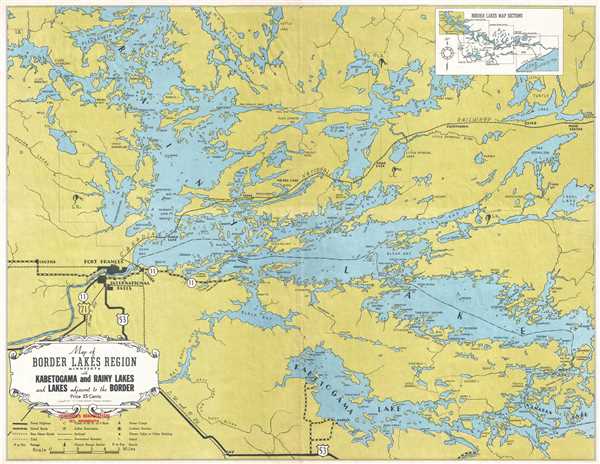
Map of the Border Lakes Region Minnesota with Kabetogama and Rainy Lakes and Lakes Adjacent to the Border.
1939 (dated) 16.75 x 21.75 in (42.545 x 55.245 cm) 1 : 131000
1939 (dated) 16.75 x 21.75 in (42.545 x 55.245 cm) 1 : 131000
Description
This is a 1939 W. A. Fisher Company map of the border lakes region of Minnesota around Rainy Lake and Kabetogama Lake. The map depicts the region from west of Fort Frances and International Falls to Namakan Lake, Shoal Lake, and Mine Centre on the Canadian National Railway and from Alexandra Bay in Rainy Lake to Irvin Bay in Kabetogama Lake and U.S. Highway 53. The region is illustrated in great detail, with bays and small islands labeled throughout Rainy Lake, Kabetogama Lake, and Namakan Lake. The border between the United States and Canada is easily discernible, as it is a line made up of a series of dots and dashes. Indian reservations are depicted, along with paved roads, gravel roads, and railroads. A diagram of the Border Lakes Map Sections is included in the upper right corner, which illustrates how the seven different sections fit together. A key explaining all the notations used on the map is located in the lower left corner, just below the title cartouche.
This map was published by the W. A. Fisher Company in 1939, and appears to have been distributed (more likely sold) at Fisherman's Headquarters in Ely, Minnesota.
This map was published by the W. A. Fisher Company in 1939, and appears to have been distributed (more likely sold) at Fisherman's Headquarters in Ely, Minnesota.
Condition
Very good. Blank on verso.
References
OCLC 455550481.