1921 U.S. Geological Survey Map of the Katalla Oil Field, Alaska
KatallaOilField-usgs-1921$250.00


Title
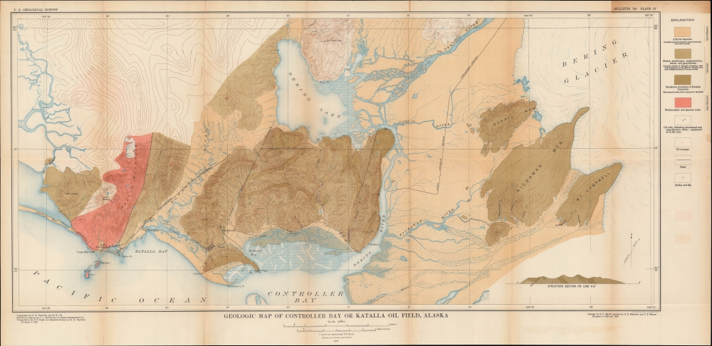
Geologic Map of Controller Bay or Katalla Oil Field, Alaska.
1921 (dated) 16 x 33.75 in (40.64 x 85.725 cm) 1 : 62500
1921 (dated) 16 x 33.75 in (40.64 x 85.725 cm) 1 : 62500
Description
A colorful large-format 1921 map of the region around Katalla in southern Alaska, produced by the U.S. Geological Survey. It presents the area following an oil and coal boom at the start of the 20th century that saw it inundated with aspiring oilmen, only to collapse within a matter of a few years.
Oil continued to be extracted in limited quantities and a refinery was built in 1911, but the product was only sold locally, and even then, largely because oil and gas claims were strictly limited in the rest of Alaska between 1910 and 1920. Nearby coal fields proved somewhat more enduring, but by the late 1920s they were no longer profitable to operate. Therefore, by 1930 Katalla was rapidly dying, and by 1950 it was a ghost town.
A Closer Look
Coverage includes the region around Katalla from Mt. Lazier in the west to the Bering Glacier in the east, taking in Bering Lake and the Bering River. A color-coding system explained at right indicates the type and age of rock in the area, while symbols indicate the location of wells, oil seepage, faults, and notation for strike and dip. A cross-section revealing the location of a fault appears at bottom-right. Elevation, waterways, railways, settlements, and more are labelled. Several rail lines and oil wells are marked as abandoned, a sign of the collapse of the oil boom in this region, the first commercial-scale oil production in Alaska's history.The Birth of Alaska's Oil Industry
The beginnings of the oil industry in Alaska can be traced to September 1902, when high-grade petroleum was discovered at multiple locations at or near the surface near Katalla. At the time, Alaska was best known for gold mining and coal production, but far-sighted investors understood that the huge region must contain a wealth of other resources that could be exploited for decades to come and multiple companies were seeking oil throughout the territory. As with the recent gold rushes in Alaska and the Yukon, thousands of ambitious would-be oilmen descended on the site. Among them was John Franklin Alexander Strong, future governor of the territory, who in 1907 founded Katalla's first newspaper, which exaggerated the area's potential and minimized troubling signs. By that time, oil wells were already drying up, investors began abandoning Katalla, and George Martin, the USGS geologist who authored the 1921 report with which this map appeared, had argued in the USGS Bulletin that the geology of the area could not sustain large quantities of oil. By 1910, the boom town's population had already shrunk to less than 200.Oil continued to be extracted in limited quantities and a refinery was built in 1911, but the product was only sold locally, and even then, largely because oil and gas claims were strictly limited in the rest of Alaska between 1910 and 1920. Nearby coal fields proved somewhat more enduring, but by the late 1920s they were no longer profitable to operate. Therefore, by 1930 Katalla was rapidly dying, and by 1950 it was a ghost town.
Publication History and Census
This map was produced by the U.S. Geological Survey in 1921 to accompany the text Preliminary Report on Petroleum in Alaska by G. C. Martin that appeared in the survey's Bulletin. It is only independently cataloged among the holdings of the University of Calgary while the entire report and the full 1921 issue of the Bulletin are more widely distributed.Cartographer
The United States Geological Survey (1878 - Present), aka the U.S.G.S., is a scientific agency of the United States government, which was founded in 1879. USGS scientists study the landscape of the United States, its natural resources, and the natural hazards that threaten it. The organization has four major science disciplines: biology, geography, geology, and hydrology. It is a bureau of the United States Department of the Interior and is the department's only scientific agency. More by this mapmaker...
Source
Martin, G., Preliminary Report on Petroleum in Alaska, (U.S. Geological Survey Bulletin 719, Washington, D.C.: Government Printing Office) 1921.
Condition
Good. Wear and toning along original fold lines. Verso repairs to fold separations and at fold intersections. Closed tear extending 2.25 inches into printed area in top right corner professionally repaired on verso. Closed tear extending 1 inch within printed area near Alluvial Deposits in Explanation in upper right corner professionally repaired on verso.
References
OCLC 150513280.