1988 Mandala Maps White Print Trekking Map from Kathmandu, Nepal, to Lhasa, Tibet
KathmanduTibet-mandalamaps-1988$600.00


Title
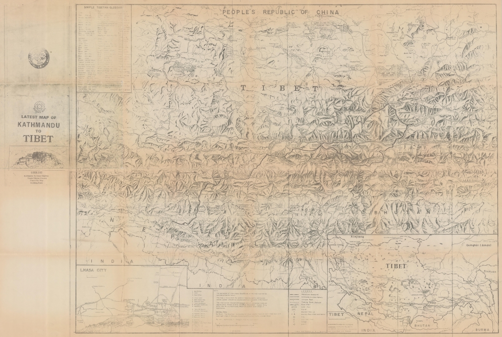
Latest Map of Kathmandu to Tibet.
1988 (undated) 30.25 x 45.25 in (76.835 x 114.935 cm) 1 : 1000000
1988 (undated) 30.25 x 45.25 in (76.835 x 114.935 cm) 1 : 1000000
Description
This is a c. 1988 Mandala Maps trekking map of Nepal and Tibet, highlighting a trekking route between Kathmandu and Lhasa.
A Closer Look
Coverage embraces from west of Kathmandu to east of Lhasa, with a dark line highlights the route between. Villages along the route are identified and their elevations are noted. Major peaks are labeled, among them Mt. Everest. Dashed lines follow trekking routes throughout, underscoring the opportunities available to intrepid travelers. Roads, rivers, glaciers, and lakes complete the regional overview. An inset situated in the lower left details Lhasa itself, with schools, monasteries, and Tibet University labeled. 21 other locations are numerically identified, including temples, hotels, the post office, and the bus station. A second inset, in the lower right, situates Nepal and Tibet in Asia and illustrates the disputed boundary between India and China.Kathmandu to Lhasa
Trekking from Kathmandu to Lhasa in the 1980s was a challenging and adventurous journey through the Himalayan region, characterized by remote and rugged terrain. During this decade, travel to Tibet was restricted and tightly controlled by the Chinese government. Tourists, including trekkers, required special permits and had to join organized tours with government-approved guides. The journey typically involved overland travel from Kathmandu to the Tibetan border and then further trekking into Tibet, passing through awe-inspiring landscapes, high mountain passes, and remote Tibetan villages. The trek offered a unique glimpse into the culture and spirituality of Tibet but required careful planning, acclimatization, and adherence to strict regulations.Publication History and Census
This map was drawn by P. L. Shrestha and published by Mandala Maps and Himalaya Bookseller. We note a single cataloged example which is part of the collection at the Zentralbibliothek Zürich.Condition
Very good. Light wear and toning along original fold lines. Verso repairs to a few fold separations. Closed margin tears professionally repaired on verso. Two small areas of infill at fold intersections.
References
OCLC 637932259.