This item has been sold, but you can get on the Waitlist to be notified if another example becomes available, or purchase a digital scan.
1571 Camocio Map of Kefalonia, Greece
Kefalonia-camocio-1571$375.00

Title
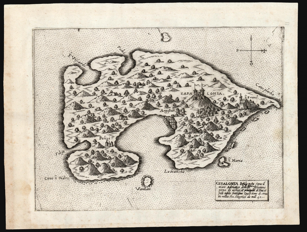
Cefalonia Insula posta sopra il mare Adriatico delli Ill.mi Venetiani piena di arbori et principalm.e di Pini et fichi insula fertilissima ...
1571 (undated) 6 x 8.25 in (15.24 x 20.955 cm)
1571 (undated) 6 x 8.25 in (15.24 x 20.955 cm)
Description
This is a scarce, separately-issued Lafreri-type map of the Greek island of Kefalonia, produced in 1571 by the Venetian Giovanni Francesco Camocio.
The popularity of these works, and their utility, appear to have influenced Ortelius in his project of creating the first true, uniform atlas in 1570. Despite the proliferation of Italian mapmakers in the 1560s and 70s, only a few appear to have lived beyond the Italian plagues of 1575-77, and these survivors seem to have prospered mainly by their acquisition of plates engraved prior to those plagues. The absence of any Italian response to Ortelius' work is more likely to have been a product of the devastation wrought by the pestilence than any overwhelming superiority of the Flemish work.
A Closer Look
Camocio's source is unknown. The map is oriented to the north, and shows several towns and churches, including the port of Argostoli. Atop the island's namesake peak is Agios Giorgios or Castle Kefalonia. In the cartouche, the island is described: its situation in the Adriatic Sea, its possession by the 'Illustrious Venetians,' and its fertility: full of fig and pine trees. Inconsistencies in the geography suggest that Camocio did not have access to a proper survey of Kefalonia. Most likely the map was based on verbal reports.The 'Lafreri' School
Between 1544 and the 1580s, Rome and Venice saw the production of a number of elegant, rare, and consequently now highly sought-after maps. These are frequently classified collectively as belonging to the 'Lafreri-School,' a term used due to the survival of a 1572 catalog of maps from the stock of publisher Antonio Lafreri. The close resemblance of this list to the contents of various bound collections of Roman and Venetian maps of the period led to these proto-atlases to be attributed to Lafreri, despite the maps having been produced by over a dozen different mapmakers, including Lafreri himself, his heir Duchetti, the Bertellis, Gastaldi, Camochio, Zenoni, Salamanca, Forlani, Ligorio, Tramezini, Zaltieri and others. These cartographers, mapmakers, engravers, and publishers, some of whom shared formalized partnerships, left a legacy of some six or seven hundred maps, all of which are scarce due to their not having been included in a standard atlas. Although generally sold in assembled-to-order, composite 'atlases,' the contents of these works varied wildly, and those that survive are poorly cataloged. Since the maps in these composite works were not intended to be compatible, bookbinders had to go to lengths to combine them: pasting smaller maps down to larger sheets, which were then stitched into the books, or larger maps trimmed close and then folded to fit smaller bindings. We have also encountered some maps, usually found separately, yet printed to the same sheets to be included together in bound works.The popularity of these works, and their utility, appear to have influenced Ortelius in his project of creating the first true, uniform atlas in 1570. Despite the proliferation of Italian mapmakers in the 1560s and 70s, only a few appear to have lived beyond the Italian plagues of 1575-77, and these survivors seem to have prospered mainly by their acquisition of plates engraved prior to those plagues. The absence of any Italian response to Ortelius' work is more likely to have been a product of the devastation wrought by the pestilence than any overwhelming superiority of the Flemish work.
Publication History and Census
This is the first state of the map, engraved by Camocio in 1571 and separately issued. A second state exists with an engraved plate number '41' in the lower right, absent here. This would have been added around 1575 by Bertelli when the plate was included in Isole Famose, Porti, Fortezze e Terre Maritime, the mapmaker's posthumous isolario. We see only three examples of this separate map listed in institutional collections: the Bayerische Staatsbibliothek, the Sachsische Landesbibliothek, and the British Library.Cartographer
Giovanni Francesco Camocio (Camozzi)(???? - c. 1575) was a Venetian cartographer, map publisher and printer. He was one of the most prolific of the so-called Lafreri school of Italian mapmakers in the second part of the sixteenth century. Little is known of Camocio's early years. His birthdate and place are not known. He is thought to have lived in Asola (near the Venetian fortress of Crema). In 1552 'Giovanni Francesco Camozzi' and his partners petitioned the Doge of Venice for a 15 year privilege for two books in progress, one a translation of a Greek medical text and the other a translation of Aristotle's Meteorology. The latter was published in 1556 by which time he was operating free of his unnamed partners. He would publish eleven more books until 1571, by which point he is known to have his own copper-plate printing shop. His output includes engravings of drawings and paintings by Titian, and various religious scenes. He is best known as a map printer, being among the Italian map publishers known collectively as the 'Lafreri' school (after Antonio Lafreri, the first of these to include a title sheet in his composite atlases.) The period between 1560 and 1575 resulted in Camocio's publication of no fewer than 36 large maps and many smaller format works. The end point of Camocio's production coincided with the plague which devastated Venice between 1574 and 1577. As there is no record relating to the man after 1575, it is very likely that he succumbed to the pestilence. More by this mapmaker...
Condition
Excellent. Trimmed to neatline and mounted to old paper as issued; some marginal spotting, else fine.
References
OCLC 163411107. cf. Bifolco, S. / Ronca, F. Cartografia e Topografia Italiana del XVI Secolo, Map 702 (second state). Akharakis, C. G., A Catalogue of Printed Maps of Greece 1477-1800, #783.