1814 Carey / Gridley Map of Kentucky
Kentucky-carey-1814-2$800.00

Title
Kentucky.
1814 (undated) 10.25 x 18.25 in (26.035 x 46.355 cm) 1 : 1520640
1814 (undated) 10.25 x 18.25 in (26.035 x 46.355 cm) 1 : 1520640
Description
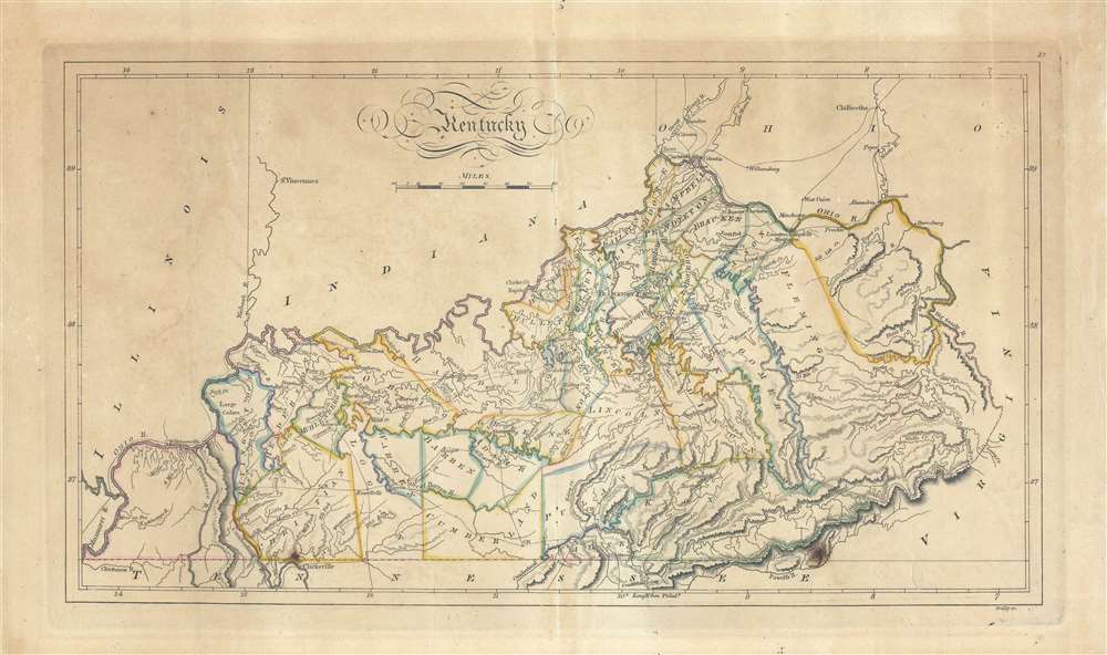
An 1814 map of the state of Kentucky by Matthew Carey and engraved by Enoch Gridley for the 1814 edition of Carey's General Atlas. Produced roughly twenty years after Kentucky gained statehood, it gives a sense of the rapid development of the state.
As with many parts of the young republic, place names were not entirely settled, and some of those that appear here later changed. For instance, to the south of Louisville, near the birthplace of Abraham Lincoln in Hodgenville (not indicated here), 'Bairdton' became Bardstown, while the settlement of Bealsburg near today's Fort Knox disappeared entirely.
In the years since Carey first published his map of Kentucky (kentucky-carey-1795), the state's population had grown rapidly. Around the start of the American Revolutionary War (1775 - 1783), the area's white population was in the low hundreds, yet large numbers of settlers migrated there during and after the conflict. Between the 1790 and 1810 censuses, Kentucky's population more than quadrupled (though not yet a state, Kentucky was counted separately from Virginia in the 1790 census).
A Closer Look
Counties and regions are distinctly outlined, while rivers, creeks, towns, roads, mountains, and a host of additional geographical features are noted. Along the Ohio River, Cincinnati stands out prominently towards top, while to the southwest Louisville is noted with relatively small text, belying its rapid growth at this time. Lexington, the state's largest town, sits at the convergence of five roads.As with many parts of the young republic, place names were not entirely settled, and some of those that appear here later changed. For instance, to the south of Louisville, near the birthplace of Abraham Lincoln in Hodgenville (not indicated here), 'Bairdton' became Bardstown, while the settlement of Bealsburg near today's Fort Knox disappeared entirely.
In the years since Carey first published his map of Kentucky (kentucky-carey-1795), the state's population had grown rapidly. Around the start of the American Revolutionary War (1775 - 1783), the area's white population was in the low hundreds, yet large numbers of settlers migrated there during and after the conflict. Between the 1790 and 1810 censuses, Kentucky's population more than quadrupled (though not yet a state, Kentucky was counted separately from Virginia in the 1790 census).
Publication History and Census
This map was engraved by Enoch G. Gridley and issued as Plate No. 21 in the 1814 edition of Carey's General Atlas; the first atlas made in the United States to use a standardized color model. It is only independently cataloged by the David Rumsey Historical Map Collection and is scarce to the market.CartographerS
Matthew Carey (January 28, 1760 - September 16, 1839) was a Dublin born publisher who established himself in Philadelphia in the late 18th and early 19th century. A young man of socially progressive views, Carey's first known publication, produced when he was but 17 years old, was a pamphlet criticizing dueling. Another pamphlet, issued in the same year, attacked the Irish penal code. Shortly afterwards, in 1779, legal issues, possibly arising from his liberal political activism, forced Carey to flee to Paris. In Paris, Carey had the good fortune to befriend the visiting American diplomat and founding father, Benjamin Franklin (1706 - 1790). As an Irishman chafing under the rule of England, Carey sympathized with and admired the American revolutionary. The liberally minded pair struck up a lifelong friendship and Carey was hired to work at Franklin's press in Passy, France. A year later, Carey returned to Ireland and resumed his politically provocative publishing career with The Freemans's Journal and The Volunteer's Journal. It didn't take long for political pressure to once again force Carey from Ireland - this time to America (1784). Although largely without funds, Carey convinced Gilbert du Motier, Marquis de Lafayette (1757 - 1834), who he knew from Franklin's Paris circle, to lend him funds to establish a new publishing concern in Philadelphia. Despite this loan, Carey's firm remained under financed and opened on a shoestring budget. It was most likely his limited budget that led Carey to some of his most important publishing innovations. At the time cartographic publishing was dominated by large printing houses in London and Paris where most, if not all, of the work was completed in house. Without the finances to emulate this large publishing houses, Carey was forced to outsource much of his publishing work. This set the stage for subsequent American publishers who, in order to compete effectively with European firms, relied on an often bewildering network of alliances and collaborations. Carey was also a master of republishing many of his own maps in multiple different atlases and formats to maximize their profitability. His most important work is without a doubt the 1795 issue of the American Atlas the first atlas to be published in America. Carey died in 1839 but was succeeded by his son Henry Charles Carey (1793 - 1879) who, in partnership with his brother-in-law Isaac Lea (1792 - 1886), published numerous important maps and atlases under the Carey and Lea, Lea Brothers, and Lea and Blanchard imprints. More by this mapmaker...
Enoch G. Gridley (fl. c. 1803 - 1818) was a Philadelphia-based engraver of maps and prints, known primarily for his map engravings for the latter editions of Carey's General Atlas. Learn More...
Source
Carey, M., Carey's General Atlas, (Philadelphia) 1814.
Condition
Good. Even toning. Centerfold and occasional creases visible. Repaired tear at bottom-right below the 'V' in Virginia. Two dark spots towards bottom.
References
Rumsey 4577.021. Phillips (Atlases) 722, 1372.