This item has been sold, but you can get on the Waitlist to be notified if another example becomes available, or purchase a digital scan.
1796 John Reid Map of Kentucky - one of the earliest obtainable maps of Kentucky
Kentucky-reid-1796$650.00

Title
Map of the State of Kentucky; with the Adjoining Territories. 1795.
1796 (dated 1795) 15 x 18 in (38.1 x 45.72 cm) 1 : 1500000
1796 (dated 1795) 15 x 18 in (38.1 x 45.72 cm) 1 : 1500000
Description
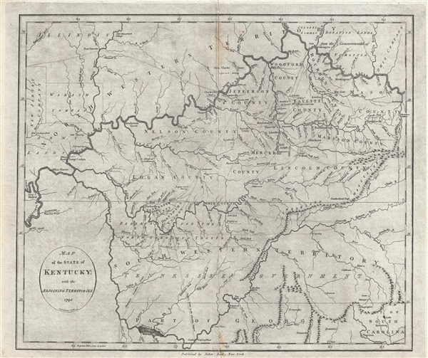
This 1795 map by John Reid is one of the earliest obtainable maps of Kentucky and Tennessee. Centered on the Cumberland River, the map covers from New Madrid on the Mississippi River to, roughly, the Cumberland Gap, and from the confluence of the Ohio and Great Miami River to northern Georgia. The towns of Lexington, Louisville, Nashville, Knoxville, etc. are noted. Identifies Leestown, which was the first Anglo-American settlement on the north side of the Kentucky River and is now part of Frankfort. Pioneer roads, called traces, are also identified throughout. The land grants of the New Jersey Companies, Wabash Company, the General Clark's Grant, the Ohio Company and Colonel Simmens in the surrounding territories are noted. The cartographer appears to have had only a tenuous grasp on the topography of the region and, other than a narrow presentation of the Cumberland Mountains, the land appears flat and well watered by an elaborate network of rivers.
The map offers much of interest from a preliminary overview of the Tennessee Governments, to interesting annotations like 'Reserved for the North Carolina Troops,' 'Colonel Simmes Donation Lands,' ' the Wabash and new Jersey Companies, and much more. We can only being to scratch the surface here.
The New Jersey and Wabash Companies were private joint stock ventures predating the American Revolutionary War that were formed to purchase and settle American Indian lands. Despite collecting considerable investment and purchasing vast tracts of territory both companies were based upon an illegal premise. Before the Revolution, the Royal Proclamation of 1763 forbade private purchase of Native American lands, so Great Britain refused to recognize these transactions. Following the outbreak of the American Revolutionary War, officials of the merged Illinois-Wabash Company appealed to both Virginia (which claimed the Illinois Country) and to the United States to recognize their land purchases, but were unsuccessful. After the United States bought the land in question from Native Americans and resold it, the matter eventually went to the Supreme Court of the United States. In Johnson v. M'Intosh (1823), the Court ruled that the U.S. government, following earlier British precedent, would not recognize private purchases of native lands, and that New Jersey and Wabash Company's purchases were therefore invalid.
This map's treatment of Tennessee, labeled here as both the South Western Territory (referring to North Carolina's Claims) and the Tennessee Government, is exceptionally interesting. The entirety of Tennessee was originally included in North Carolina's coast to coast charter which – for practical political purposes was generally assumed to terminate at the Mississippi River. Tennessee's easternmost counties were thus originally the western most counties of North Carolina. In the years following the American Revolutionary War the government of North Carolina was too depleted to defend its westernmost settlements against American Indian attacks or support their right to navigate the Mississippi River. Tennesseans realized they would have to look to themselves for military support. In 1784 Tennessee's eastern counties rallied and attempted to form the new state of Franklin with John Sevier as governor. Meanwhile, in western Tennessee, the Cumberland Settlements ratified the Cumberland Compact and even brokered a treaty with Spain. Despite bold aims, both the Cumberland Compact and attempts to promote the state of Franklin lacked federal support and were suppressed by North Carolina. This changed in 1789 when North Carolina ratified the constitution and joined the Union. In doing so it gave up the rights to its western land paving the way for Tennessee to peruse statehood in 1795-6.
A number of early towns and settlements are noted, many with names evocative of the frontier aspect of this region at the end of the 18th century. Howards Settlement appears on the Muddy Rier. On the Ohio Henderson's Grant is noted. Lystra, founded by London speculators on paper but not in fact, appears in Nelson County. The speculators imaged a grand town arranged in a grid structure much like Savannah Georgia, but it never reach fruition. Another spurious utopic vision of English speculators, Ohiopiomingo, appears just to the north on the Ohio River. Still another utopic settlement, Franklinville, named after Benjamin Franklin, is situated on the north fork of the Kentucky River.
Unlike many of the American maps in Reid's atlas, this map first appeared in the English publication Winterbotham's Historical, Geographical, Commercial and Philosophical View of the United States where it was engraved by John Russell. The map present here, bears the John Reid imprint and was issued in Reid's American Atlas.
CartographerS
John Reid (fl. c. 1775 - c. 1800) was an American bookseller and commercial mapmaker active in New York during the latter part of the 18th century. He is known for publishing the second American commercial atlas, the 1795 American Atlas. Unlike most American printers of his day, which were based in Philadelphia, Reid maintained his office at 106 Water Street, New York City. Little else is known of Reid's life and career. More by this mapmaker...
John Russell (c. 1750 - 1829) was a British cartographer active in London during the late 18th and early 19th centuries. Russell apprenticed as a goldsmith under William Palmer before turning to engraving and printing. He drew maps and engraved for several major publishers of his period including Alexander Dalrymple, Benjamin Henry, Robert Sayer, John Moore, and William Guthrie. Russell's 10 apprentices included such prominent cartographers as Alexander Findlay and Samuel Clapp. Russell was based on Constitution Row Grays Inn Lane, Middlesex (London). Learn More...
Source
Reid, J., An American Atlas (John Reid: New York) 1796.
An American Atlas, published by John Reid in 1796 is the second commercial atlas published in the United States. It is considered among the rarest and most interesting of all American atlases. Reid's atlas was originally issued as an accompaniment to Winterbotham's Historical, Geographical, Commercial and Philosophical View of the United States, but easily stands on its own as a production of outstanding merit. The original atlas contained 20 or 21 maps, including detailed engraved maps of North and South America, and the United States; and individual maps of New Hampshire, Maine, Massachusetts, Vermont, Rhode Island, Connecticut, New York, New Jersey, Pennsylvania, Delaware and Maryland, Virginia, Kentucky, North Carolina, South Carolina, Georgia, Tennessee, and the West Indies. The continent maps, the general map of the United States, and those of Kentucky and Washington are after maps appearing in London editions of Winterbotham; the remaining maps are unique to this work. Of the new maps, most are drawn loosely from those maps appearing in John Carey's 1795 American Atlas or, in the case of the Kentucky map, from the J. Russell's work for the 1795 London edition of Winterbotham. Most of the maps in Reid's American Atlas were engraved by Benjamin Tanner, brother to Henry S. Tanner, the most prominent map engraver in the United States. Others were engraved by David Martin, D. Anderson, John Scoles, and John Roberts. Some examples of the The American Atlas also featured the scarce Andrew Ellicott map of Washington D.C. It is noteworthy that most examples of the atlas are printed on inconsistent stock and suffer from severe condition issues due to the fact that the individual maps were printed in various different locations then shipped to Reid for binding. Reid's An American Atlas exists in only one edition and is unlikely to have been successful given the scarcity of all examples today.
Condition
Very good. Minor soiling on centerfold. Blank on verso. Archival verso reinforcement along original centerfold.
References
Rumsey 0845.015. Phillips (America) page 351. Clark, T. D., Historic Maps of Kentucky, pages 67 – 68.