This item has been sold, but you can get on the Waitlist to be notified if another example becomes available, or purchase a digital scan.
1886 Titcomb Map of Kerr City and Norwalk, Marion County, Florida
KerrNorwalkFlorida-titcomb-1886$3,000.00


Title
Norwalk and Kerr City Florida.
1886 (undated) 25.25 x 31 in (64.135 x 78.74 cm) 1 : 31680
1886 (undated) 25.25 x 31 in (64.135 x 78.74 cm) 1 : 31680
Description
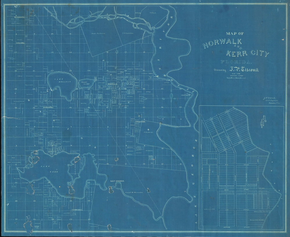
This is a unique c. 1886 cyanotype map of Norwalk and Kerr City, Marion County, north central Florida, by Civil Engineer John Poore Titcomb. The map provides a unique overview of the short-lived Citrus Boom communities west of the St. John's River before the disastrous freezes of 1894-95, highlighting property owners, including the mapmaker, throughout.
A Closer Look
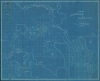
Coverage embraces from Lake Kerr and Lake Delancy to northern Lake George and the St. Johns River - an area today part of Ocala National Forest. The primary communities illustrated are Kerr City, Harvard, Norwalk, and Syracuse. The survey names various land holders, including, just northwest of Kerr City, the homestead tracts of the mapmaker J. P. Titcomb (three tracts), and his father Silas Moulton Titcomb (1838 - 1924). There is a detailed inset of Kerr City in the lower right, identifying the hotel, newspaper, two sawmills, and the overall street grid and lot structure.Kerr City
Today Kerr city is a ghost town on the northern shore of Lake Kerr, Marion County. The lands were first mapped in 1835 by government surveyor Robert Kerr, who named nearby Lake Kerr. They were developed and run as a cotton plantation until the American Civil War (1861 - 1865). With the first Florida Citrus Boom, cotton was uprooted to plant sprawling orange plantations. Kerr City, riding on the boom and homesteader acts, was founded in 1884. It had twenty-six blocks occupying 205 acres, and by 1894 boasted a population of 100. It maintained a post office, school, general store, newspaper, sawmill, and an impressive multi-story hotel. The town seemed to have a bright future as a center of orange production until the freezes of 1894 - 95. The freezes devastated northern Florida's citrus economy, forcing farmers and laborers to migrate elsewhere. By the second round of freezes in 1904 - 05, the city was mostly abandoned. In the 1950s, George Smiley, a descendent of one of the original homesteader families, began buying up the land. Today his descendants still own and maintain it - somewhat. Kerr City is not open to the public, but occasional 'ghost hunters' and 'explorers' make their way in.Cyanotype: Why so Blue?
Cyanotype is a photo-reprographic technique developed in 1842 by the British astronomer John Herschel (1792 - 1871). Sometimes called a 'sunprint', the technique employs a solution of ferric ammonium citrate and potassium ferricyanide, which painted on white paper or cloth, reacts when exposed to sunlight to dye the object a brilliant blue. Areas blocked from ultraviolet exposure remain undyed and white. Herschel developed the technique to reproduce his astronomical notes, but others quickly realized that any object capable of blocking light could be used to create a cyanotype image quickly and easily. By the late 19th century, the process became popular with designers, military, architects, and engineers (blueprints), who used the cheap and effective technique to quickly and exactly reproduce images in the field. Cyanotyping is limited in that only a single copy can be made at one time, so it was only practical for short-term field work. It is also of note that cyanotypes remain extremely reactive to light and, over time, fade or degrade, making them extremely ephemeral. The process fell out of fashion in most places by the 1920s but remains in use in some parts of the world, such as India and Nepal, to this day.Publication History and Census
This is the only known example, cyanotyped by J. P. Titcomb himself from his own original manuscript survey, now lost. We have dated it to 1886, when Titcomb was active in this area and received his homesteader patents.Cartographer
John Poore Titcomb (April 7, 1861 - June 26, 1932) was a civil engineer active in Florida and later Maine in the late 19th and early 20th century. Titcomb was born in West Newbury, Massachusetts. In both 1885 and 1886 he received homestead patents in Florida, near Lake Kerr, and in 1887, he appears in the Jacksonville city directory as a Civil Engineer. Similarly, in 1887, we see an advertisement for his services as a Notary and Civil Engineer in the Palatka Daily News. There he promotes his skill with the 'Blue Process' of map reproduction. He married Mary B. Todd (1868 - ????) in 1891. In this same year he was doing railroad and real estate surveys in and around Amesbury. Titcomb likely gave up these grants following the great freezes of 1894 - 1895, which devastate the Florida citrus industry. From 1892, until about 1899, Titcomb served as the City Engineer for St. Petersburg, Florida. Around 1900, he relocated to Amesbury, Massachusetts, where he was active as a surveyor and in the local Masonic lodge. It is likely he spent his winters in St. Petersburg and retained real estate interests there throughout this period. Sometime in the 1920s he appears on voter rolls in California, but he must have returned to Amesbury, as he died there in 1931. More by this mapmaker...
Condition
Good. Map is laid on old linen. Several areas of infill in the lower left quadrant.