This item has been sold, but you can get on the Waitlist to be notified if another example becomes available, or purchase a digital scan.
1913 Slattery / Army Corps of Engineers Chart of Key West
KeyWest-slattery-1913$250.00

Title
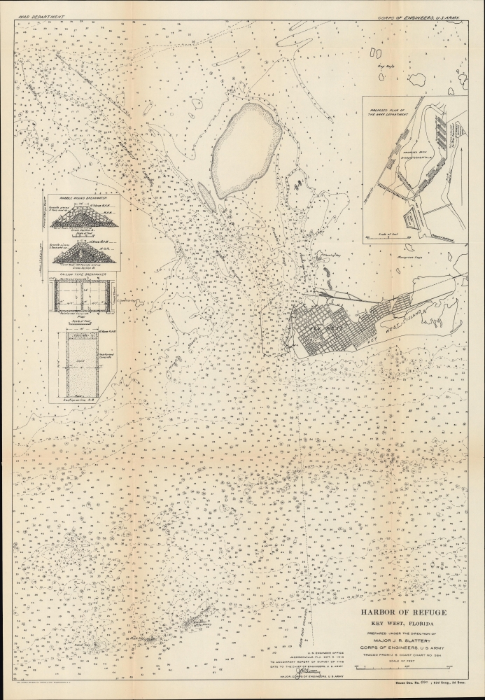
Harbor of Refuge Key West, Florida... Traced from U. S. Coast Chart No 584.
1913 (dated) 24.25 x 16.5 in (61.595 x 41.91 cm) 1 : 40000
1913 (dated) 24.25 x 16.5 in (61.595 x 41.91 cm) 1 : 40000
Description
A fascinating nautical map, including a city plan of Key West, Florida, and technical schematics of a breakwater, produced in 1913 by Major J. R. Slattery of the U.S. Army Corps of Engineers. It displays the city and island at the start of a boom, brought about by the completion of the Florida East Coast Railway.
Despite an enviable situation, at the southernmost point in the contiguous United States, the development of Key West was initially hampered by difficulties of access, by sea due to the shallow depths, rocks, and other hazards that would doom ships of any considerable size, and by land, as the island was unconnected to other keys, let alone the distant Florida mainland. A combination of public and private efforts sought to correct these problems, with the Army Corps of Engineers focusing on dredging access channels for larger ships and establishing breakwaters (seen here in an inset at left) to manage coastal water levels, including storm surges (powerful hurricanes hit Key West in 1909 and 1910). Perhaps more importantly, in 1912 an 'overland' connection was built by the Florida East Coast Railway, seen at right.
A Closer Look
Covering Key West and its immediate surrounding waters, this chart emphasizes the great variations in seawater depths in the approaches to Key West. Soundings are provided throughout, and hazards, shoals, shipping channels, adjacent keys, jetties, and other features are illustrated. An inset at right displays a proposed basin, ultimately built along these lines, just north of Fort Taylor.Despite an enviable situation, at the southernmost point in the contiguous United States, the development of Key West was initially hampered by difficulties of access, by sea due to the shallow depths, rocks, and other hazards that would doom ships of any considerable size, and by land, as the island was unconnected to other keys, let alone the distant Florida mainland. A combination of public and private efforts sought to correct these problems, with the Army Corps of Engineers focusing on dredging access channels for larger ships and establishing breakwaters (seen here in an inset at left) to manage coastal water levels, including storm surges (powerful hurricanes hit Key West in 1909 and 1910). Perhaps more importantly, in 1912 an 'overland' connection was built by the Florida East Coast Railway, seen at right.
The Florida East Coast Railway
The Florida East Coast Railway (F.E.C.) extension to Key West, possibly the greatest railroad achievement of the era, was planned from about 1895, but not completed until 1912. It operated for little more than 20 years, heralding a golden age for the Florida Keys and Key West in general. Business magnates, presidents, and dignitaries rode the rails to Key West before embarking on Flagler’s Peninsular and Occidental Steamship Company to Havana, Cuba, and the Bahamas. Long after Flagler’s death, the Labor Day Hurricane of 1935 destroyed some of the railroad bridges leading to Key West (the remains of which can still be seen), and the F.E.C., then insolvent, could not finance repairs. The tracks and bridges were sold to the state, which incorporated the F.E.C. infrastructure with the existing Route 4A to build the Overseas Highway (U.S. 1). In 1939, following the conversion of railroad bridges to automobile use, the highway to Key West was opened.Publication History and Census
This map was prepared by Maj. J. R. Slattery of the U.S. Army Corps of Engineers, working off a nautical chart made by the U. S. Coast Survey. It accompanied 'Reports on preliminary examination and survey of Key West Harbor,' a document presented to the U.S. House of Representatives in 1913 (House Doc. No. 680; 63rd Cong., 2d Sess.). The map is not independently cataloged with any institution, while the House Document is noted among the holdings of the University of North Texas, the University of Michigan, Faulkner University, Brown University, and the Pennsylvania Office of Commonwealth Libraries.CartographerS
Colonel John R. Slattery (January 31, 1877 - September 23, 1932) was an American engineer, Army officer, and public servant. Born in Athens, Ohio, Slattery attended and graduated from public schools in Cincinnati before entering the United States Military Academy at West Point. He graduated from West Point in 1900, was commissioned a second lieutenant, and entered the U.S. Army Corps of Engineers. He spent the next 25 years in the Corps of Engineers. He spent 3 years in charge of the Honolulu district in Hawaii, where he worked on coastal defense plans and ways to improve the Honolulu and Hilo harbors. Then he worked on several projects in Kansas before being sent to Florida to oversee coastal defenses at Key West and Tampa Bay as well as improvements to rivers and harbors throughout the state. He also worked as the district manager of the Mississippi Delta region during his career, overseeing levee and bank revetment work. During World War I Slattery served with the 312th Engineers in Bordeaux, France, where he was in charge of coordinating the handling of supplies and the hospitalization of troops. After returning to the United States, he was assigned to the Seventh Army Corps (in charge of Columbia River improvements) as chief engineer. He became district engineer in charge of all river and harbor improvements in New York State in 1923. While in New York, he was convinced to join the New. York City Board of Transportation, which he joined on April 1, 1925, as deputy chief engineer. He also became general manager of the Independent Rapid Transit System. He was general manager when the Eighth Avenue Subway opened and his doctor stated that overwork dealing with the opening of the Eighth Avenue Subway directly caused Slattery's death. He married Elizabeth Bradley, with whom he had three children. More by this mapmaker...
Norris Peters (c. 1834 – July 15, 1889) was a Washington D.C. based photo-lithographer active in the late 18th and early 19th century whom Scientific American called 'one of Washington's most eccentric and mysterious figures.' Peters was born and educated in Pennsylvania. He relocated as a young man to Washington D.C. where he took work as an examiner for the United States Patent Office. During his work with the patent office he became fascinated with the emergent process of photolithography. In 1869 Peters secured substantial venture capital of about 100,000 USD from an unknown investor and founded The Norris Peters Company at 458 Pennsylvania Avenue. Their printing offices have been described as 'unequaled in this or any other country.' From these offices Peters pioneered the development of American photo-lithography. For nearly a generation he held a near monopoly on government photo-lithographic printing. Among their more notable contracts included numerous maps for congressional reports, maps of the U.S. Coast Survey, maps of the U.S. Geological Survey, Mexican currency for the State of Chihuahua, and the Official Gazette of the Patent Office. Peters also maintained an interesting social life and was a confidant to many of the most powerful figures in Congress. He was also a bon vivant known for being an excellent cook and hosting lavish dinners, the invitations to which were 'never declined'. Despite being socially active he never married and died a confirmed bachelor. Following Peters' death in 1889 his business was taken over by Henry Van Arsdale Parsell who administered it until his own death in 1901. The company then merged with Webb & Borcorselski, another D.C. lithography firm, and was renamed Webb & Borcorselski-Norris Peters. They continued to publish under this name well into the mid 20th century. Learn More...
Source
'Key West Harbor, Fla. Letter from the Secretary of War, transmitting, with a letter from the Acting Chief of Engineers, reports on preliminary examination and survey of Key West Harbor, Fla.', House Doc. No. 680; 63rd Cong., 2d Sess., (Washington) 1914.
Condition
Very good. Light wear along original fold lines. Verso repairs to fold separations and at fold intersections. Light toning along original fold lines.
References
OCLC 892650980, 1053356818 (entire report).