1940 Suchy Pictorial Map of Key West, Florida
KeyWest-suchy-1940$500.00

Title
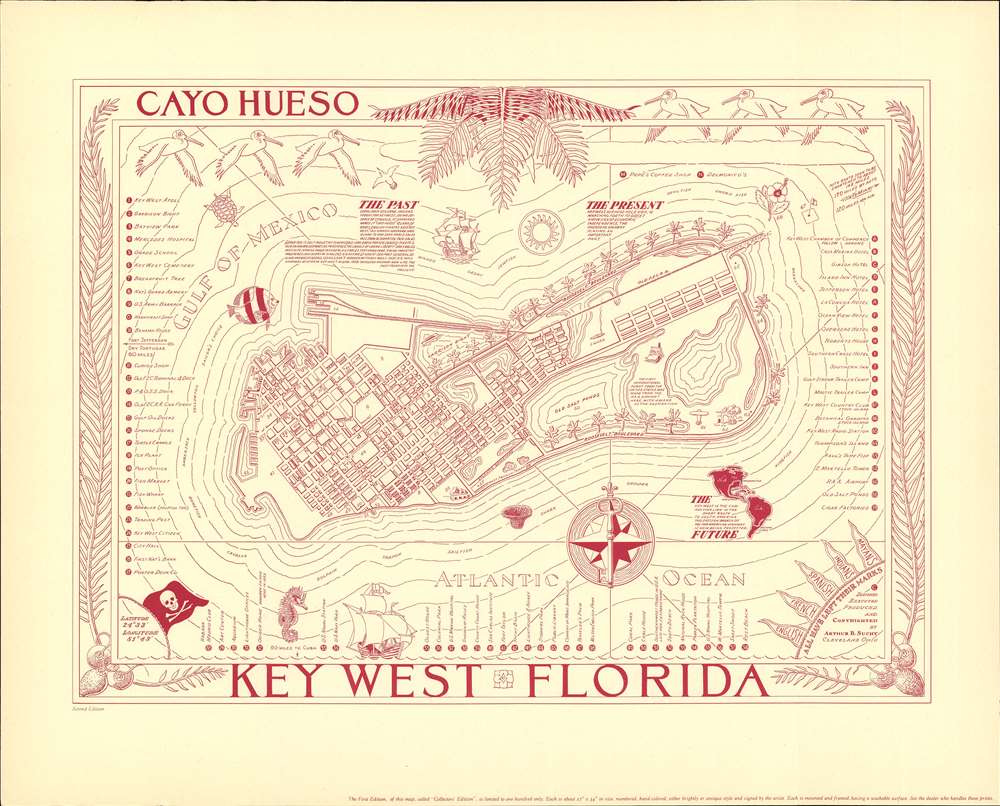
Cayo Huesco / Key West Florida.
1940 (undated) 17.5 x 22 in (44.45 x 55.88 cm)
1940 (undated) 17.5 x 22 in (44.45 x 55.88 cm)
Description
A fine c. 1940 pictorial map of Key West, Florida, issued by Arthur B. Suchy. The map covers all of Key West. City blocks are illustrated and important hotels, parks, trees, tourist attractions, and civic buildings, in all more than 59 locations, are noted. The map is surrounded by an elaborate border featuring decorative palm fronds and sea birds. Marine life and pirate ships populate the seas.
Publication History and Census
This map was published in 1940 by Arthur B. Suchy in Cleveland, Ohio. There are two editions, the first, known as the 'collectors edition' is in larger format, was issued as a limited edition with only 100 examples, and features stunning hand color. All second editions, as here, are labeled as such and, although some do feature hand coloring, they are always printed in red to distinguish them from the first.Cartographer
Arthur Bartholomew Suchy (1901 - 1995) was a 20th century commercial artist, illustrator, and pictorial mapmaker. Suchy was born in Cleveland, Ohio and studied at New York's Colgate University from 1919 to 1923, where he distinguished himself as a student politician, athlete, and sportsman. His career as an illustrator and commercial artist spanned more that 50 years, but he was most active as a mapmaker between 1920 and 1940. Other than his map of Colgate University, most of his work focuses either on his native Ohio or his adopted home, Florida. Suchy's corpus is small but striking. His first map depicts his alma mater, Colgate University (1927). In the same year he issued a similar map of Swarthmore College (1927). This is followed by his large map The Heart of Cleveland (1928). He seems to have taken a 6-year break from pictorial mapmaking to focusing on his commercial career, but issued a new pictorial map illustrating his adopted home, Miami, in 1935. A second map of Cleveland, intending to illustrate the city as it appeared in 1836, was issued in 1937. This was followed by a general map of Ohio,Buckeye State issued in 1939. His final map, illustrating Key West, appeared in 1940. Some of his latter maps, particularly his Key West map, appeared in both hand-colored 'limited edition' formats and uncolored editions for the mass market. More by this mapmaker...
Condition
Very good.
References
Rumsey 9080.000. Tampa Bay History Center, Touchton Map Library, #2019.051.001.