1985 Heuberger Topographical Map of Mount Everest
KhumbuHimal-heuberger-1985$400.00


Title
Khumbu Himal.
1985 (dated) 32.75 x 46.5 in (83.185 x 118.11 cm) 1 : 50000
1985 (dated) 32.75 x 46.5 in (83.185 x 118.11 cm) 1 : 50000
Description
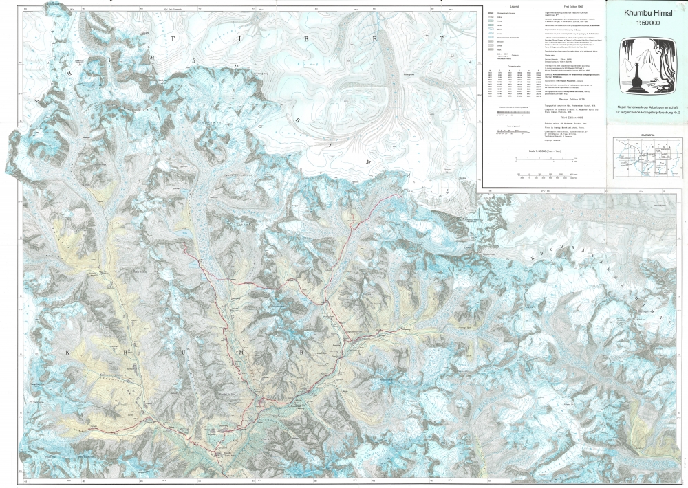
This is a striking 1985 Helmut Heuberger and Working Group for Comparative High Mountain Research (Arbeitsgemeinschaft für vergleichende Hochgebirgsforschung) map of Mount Everest and vicinity. Red manuscript notations trace the route followed by an expedition through the mountains, eventually reaching the top of the Khumbu Glacier within sight of Everest.
Follow a Trek to Everest!
The map depicts the region from the Lunag Glacier and Pigpherago Shar to Khumbakarna Himal and Chomo Lönzö and from Jobo Rabzang to Chamlang and Iswa La. Numerous locations throughout are identified, including Mount Everest (Sagarmatha), which is situated just below and to the left of the key. Towns, villages, and other settlements are labeled, including Nauche (Namche Bazar), one of the waypoints on almost all treks to Everest, and one of the places through which the expedition traced here stopped. Himalayan peaks are identified throughout, complete with their elevations (in meters), as are glaciers and lakes. Contour lines cover the whole, underscoring elevation as essential to navigation the Himilayas. A key situated in the upper right includes a legend, a conversion table from meters to feet, and a publishing history.Publication History and Census
This map was revised in 1984 by Helmut Heuberger and published in 1985 by Arbeitsgemeinschaft für vergleichende Hochgebirgsforschung, the Working Group for Comparative High Mountain Research. Two previous editions had been published in 1965 and 1978. The OCLC records examples of the 1985 edition in the institutional collections of the University of New Mexico, the University of Utah, the University of California - Berkeley, the University of Cambridge, the University of Oxford, and the University of Dresden.Cartographer
Helmut Heuberger (January 8,1923 - November 16, 2011) was an Austrian geographer and high mountain researcher. Born in Innsbruck, Austria, he attended elementary and high school there, where he was an enthusiastic member of the Hitler Youth. After completing the Reich Labor Service (a law requiring all young Germans to work for the National Socialist German Reich for a certain period of time), Heuberger volunteered for the military service. He entered the military in October 1941 and served in an anti-tank unit (Panzerjägerkompanie) on the Eastern Front. He was severely wounded at Stalingrad in February 1943 and was discharged as he was physically unable to fight. Per Claire Mulley in her book The Women Who Flew for Hitler, Heuberger became increasingly disillusioned with the Nazi Party and its leaders after his return from the Easter Front and concluded that his loyalties should lie with the German Reich and not the Führer and his deputies. Mulley states that Heuberger even helped support the Austrian resistance soon after making this decision. The winter after returning from the war, Heuberger began studying geography, geology, history, ethnology, and German at the University of Innsbruck and graduated in 1952. He held various posts at Innsbruck before accepting a position as an assistant at the Geographical Institute in 1958. During the post-war years, Heuberger also became involved with the paramilitary group the Liberation Committee of South Tyrol. After what has become known as the Night of Fire, the organized bombing of thirty-seven electricity pylons supplying power to the industrial zone of Bolzano, Heuberger even. took over leadership of the group for a short time. In 1966, Heuberger was sentenced in absentia to thirty years in prison by a court in Milan after being connected to a series of explosive attacks committed by the group. Heuberger never served any time in prison. Instead, he finished his habilitation thesis in 1965 and held posts as a guest lecturer in Hamburg and at FU Berlin before becoming an associate professor at the University of Munich in 1972. He became the chair of the Department of Geography at the University of Salzburg in 1980 and served as the Dean of the Faculty of Natural Sciences of the University of Salzburg from 1987 - 1989. He retired in 1991. Heuberger married Dr. Adhelheid Hardorp (March 29, 1929 - September 5, 2006) in 1956 and Ilse Meyer (1922 - 2011) in 2008. More by this mapmaker...
Condition
Good. Wear along original fold lines. Slight loss at fold intersections. Verso repairs to fold separations and at fold intersections.
References
OCLC 17616685.