1933 Postal Atlas of China Map of Southern Jiangsu (Kiangsu) Province
Kiangsu17-postalatlas-1933$400.00

Title
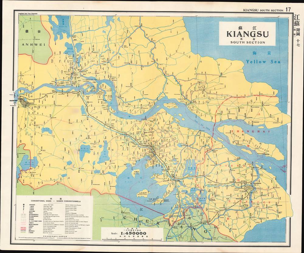
江蘇 南區 / Kiangsu - South Section.
1933 (undated) 24.5 x 29.5 in (62.23 x 74.93 cm) 1 : 450000
1933 (undated) 24.5 x 29.5 in (62.23 x 74.93 cm) 1 : 450000
Description
This is a map of southern Jiangsu (Kiangsu) Province from the 1933 edition of The Postal Atlas of China (中華郵政輿圖), compiled by Charles Jacot-Guillarmod. It illustrates the evolving postal infrastructure of the region, reflecting a broader modernization drive by the Nanjing government.
The people who lived along these rivers and canals were often subject to devastating floods in the late 19th and early 20th century, leading many to seek refuge and a new life in nearby cities, especially Shanghai. Impoverished migrants from north of the Yangzi formed an urban underclass in Shanghai and other nearby cities, filling the ranks of rickshaw drivers, prostitutes, street hawkers, and stevedores. The yawning gap in wealth and development between southern (蘇南) and northern Jiangsu (蘇北) is obvious in the paucity of postal routes, roads, and railways north of the Yangzi.
After the purging of Communists, Chiang established a new national regime in Nanjing. In the decade that followed, despite weak authority, civil war, a Communist insurgency, and an incremental Japanese invasion of northern China, the Nanjing Government and the Guomindang were able to build something like a modern, functioning bureaucratic state, particularly in the Lower Yangzi Delta around Nanjing and Shanghai, and successfully complete a range of hallmark infrastructure and modernization projects. Nevertheless, full-scale war with Japan in 1937 derailed these efforts, leading ultimately to Chiang's retreat to Taiwan and the Communist takeover of mainland China.
The second edition of the Postal Atlas was issued in 1919 following a Ministry of Education system to standardize the Beijing dialect in all elementary schools throughout China. This led to a resurgence of the Wade system. Nonetheless, in 1931, the French postal co-director Henri Picard-Destelain ordered a return to the Nanking Syllabary. The Chinese Postal System remained under French management until 1943 when the Japanese invaders ousted A. M. Chapelain, the last French head of the China Post.
A Closer Look at the Map
This map is an appendix to the map of Jiangsu, the seventeenth in the atlas series, focusing on the southern portion of the province. Southern Jiangsu was deserving of its own map because the region included not only the capital city, Nanjing (Nanking), but also the cosmopolitan metropolis of Shanghai and several other economically and culturally important cities, such as Wuxi (无锡, here Wusih), Zhenjiang (镇江, here Chinkiang), Yangzhou (here Kiangtu 江都), and Suzhou (蘇州 or Wuxian 吳縣, here Soochow or Wuhsien). The markings on the map indicated in the legend give a great deal of information about the postal and transportation infrastructure in China at this time by presenting the frequency of service along various routes. The numbers along the routes represent Chinese li (里), equivalent to roughly 500 meters.Jiangnan – Land of Waterways
The area depicted on this map, the heart of the Jiangnan region (江南), is bisected by numerous waterways, the most prominent being the Yangzi (or Yangtze) River, the Huangpu, a tributary of the Yangzi snaking through Shanghai, and Lake Tai (Tai Hu), one of the largest lakes in China. Although these waterways had formed a sort of highway system in ancient China, leading all the way to Beijing via the Grand Canal, they had fallen into disrepair and disuse in the 19th century.The people who lived along these rivers and canals were often subject to devastating floods in the late 19th and early 20th century, leading many to seek refuge and a new life in nearby cities, especially Shanghai. Impoverished migrants from north of the Yangzi formed an urban underclass in Shanghai and other nearby cities, filling the ranks of rickshaw drivers, prostitutes, street hawkers, and stevedores. The yawning gap in wealth and development between southern (蘇南) and northern Jiangsu (蘇北) is obvious in the paucity of postal routes, roads, and railways north of the Yangzi.
The Nanjing Decade
Nanjing became the capital city of China in 1927-28, following the partial reunification of the country by Chiang Kai-Shek's forces in the Northern Expedition. A key turning point in this effort was the Shanghai 'White Terror' of April 1927, when Chiang enlisted the criminal Green Gang to murder Communist agents and activists who had called a general strike in the city. This marked a definitive break between the Nationalists and Communists, who had been cooperating in an uneasy alliance to unify the country up to that point.After the purging of Communists, Chiang established a new national regime in Nanjing. In the decade that followed, despite weak authority, civil war, a Communist insurgency, and an incremental Japanese invasion of northern China, the Nanjing Government and the Guomindang were able to build something like a modern, functioning bureaucratic state, particularly in the Lower Yangzi Delta around Nanjing and Shanghai, and successfully complete a range of hallmark infrastructure and modernization projects. Nevertheless, full-scale war with Japan in 1937 derailed these efforts, leading ultimately to Chiang's retreat to Taiwan and the Communist takeover of mainland China.
The Postal Atlas of China (中華郵政輿圖)
Compiled by Charles Jacot-Guillarmod, this atlas contains maps covering all of China in considerable detail. Most were derived from regional working postal maps. The legends on the maps are written in English, Chinese, and French. The history of the The Postal Atlas of China is closely related to attempts to Romanize placenames in the Chinese Postal System. The first atlas followed the 1906 Shanghai Imperial Postal Joint-Session Conference to develop a system of Romanization following Herbert Giles' 'Nanking Syllabary.' The Giles 'Nanking syllabary' was popular with the French-dominated Chinese Postal Service, which considered the earlier Beijing-based system developed by Thomas Francis Wade as too Anglophone. As was the case for other bureaucratic offices at this time, foreign advisors were often brought in as consultants or even government officials.The second edition of the Postal Atlas was issued in 1919 following a Ministry of Education system to standardize the Beijing dialect in all elementary schools throughout China. This led to a resurgence of the Wade system. Nonetheless, in 1931, the French postal co-director Henri Picard-Destelain ordered a return to the Nanking Syllabary. The Chinese Postal System remained under French management until 1943 when the Japanese invaders ousted A. M. Chapelain, the last French head of the China Post.
Publication History and Census
There are four known editions of this atlas: 1907-08 (Shanghai, replacing the 1903 postal wall map, 21 maps plus index map), 1919 (Beijing, 47 maps), 1933 (Nanjing), and 1936 (Nanjing). The atlas was compiled by the French topographical engineer Charles Jacot-Guillarmod and published by the Directorate General of Posts (郵政總局). This edition is held by a handful of university libraries and research institutions in North America and Europe, as well as institutions in mainland China and Taiwan.Cartographer
Charles Jacot-Guillarmod (1868 – August 14, 1925) was a Swiss topographical engineer active in the late 19th and early 20th century. Charles was born in Le Chaux-de-Fonds, in the Canton of Neuchatel, Switzerland. He attended the Eidgenössische Technische Hochschule Zürich (ETHZ), where he acquired a degree in Topographical Engineering. After graduating served the Swiss Federal Topographical Bureau from 1890 – 1914, contributed significantly to the Topographical Atlas of Switzerland. He was dismissed from his government topographical posted in 1914. Independent of a paid post he turned his attentions to his interested in high alpine cartography, producing two topographical sketches of Himalayan peaks (K2 and Kanchenjunga) based upon photographs taken by his cousin, the famed mountaineer Jules Jacot-Guillarmod. From 1916 to 1922 he relocated to Beijing where he taught geodesy and topography at the Chinese Army Survey School. There, he was also contracted to compile the 1919 second edition of the China Postal Atlas. When the Chinese government could no longer pay him, he returned to Switzerland in 1923 where he compiled a large scale topographic map of Mount Olympus. His final work was a large scale map of Mount Everest commissioned by the Royal Geographical Society, London, based upon the surveying achievements of a British expedition. More by this mapmaker...
Source
China. You zheng zong ju, Zhonghua min guo you zheng yu tu, (Nanking : Directorate General of Post) 1933.
Condition
Very good. Light wear along original centerfold.
References
OCLC 5371414, 17468267.