
1931 Illinois Terminal Railroad System Pictorial Map of Illinois

This item has been sold.
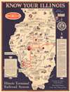
Know Your Illinois.
Highlights events in Illinois history - including several in the life of Abraham Lincoln.
Choose a Collection:
- Digital Map Information
- Suitable for large format printing
- Full resolution TIFF file
- ICC color profile embedded
- Delivered instantly via download link
This Item
Enquire
Highlights events in Illinois history - including several in the life of Abraham Lincoln.
This is a 1931 Illinois Terminal Railroad System pictorial map of Illinois. Vignettes illustrate events throughout the state's history, including the first Lincoln-Douglas debate, European exploration, battles fought between Native Americans and settlers, and other historical events. Universities and colleges, such as Northwestern and the University of Chicago, are identified. A text box on the left promotes Illinois's history, while a text box on the right extolls the virtues of the Illinois Terminal Railroad System.The Illinois Terminal Railroad System (1896 - 1956)
Founded in 1896, The Illinois Terminal Railroad System was an interurban electric railroad providing both passenger and freight service. At its height, it boasted 550 miles of track, and had affiliated street trolley lines for local passenger service. The map shows the System's network across central and southern Illinois, linking St. Louis to Springfield, Peoria, and Danville. A connection to Fallon is also shown, indicating service to the coal industry.It was a short-lived line. The Great Depression hit the ITR hard forcing it to liquidate its city streetcar lines. The eventual dominance of the automobile finally closed the ITR. It was sold in 1956, parceled out to nine separate Class 1 railroads.
Publication History and Census
This map was published by the Illinois Terminal Railroad Company in 1931. Three examples are cataloged in OCLC as part of the collections at the University of Illinois at Urbana Champaign, the University of California Los Angeles, and the Abraham Lincoln Presidential Library in Springfield, Illinois.Condition
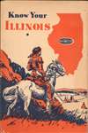
Very good. Exhibits light wear along original fold lines. Accompanied by original binder.
References
OCLC 25972426.