1944 Survey of India Map of Kohat (now Pakistan)
Kohat-surveyofindia-1944$1,200.00

Title
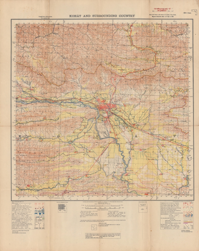
Kohat and surrounding country.
1944 (dated) 26 x 21.5 in (66.04 x 54.61 cm) 1 : 63360
1944 (dated) 26 x 21.5 in (66.04 x 54.61 cm) 1 : 63360
Description
A wartime production, this Survey of India map of Kohat and environs, now in northwestern Pakistan, was published in 1944. The noticeable presence of British military forces in and around Kohat is testament not only to fighting during World War II (1939 - 1945), but also to a long history of regional unrest.
While the considerable British military presence may have been related to the ongoing fight against Japan, it was also no doubt meant to deter unrest by local groups that had chafed against British rule for decades. From the early days of British intervention in the area in the mid-19th century, when the Northwest Frontier Road seen here (also known as the Kohat Pass) was built to Peshawar, local tribes launched uprisings and attacks on British military forces. This led to the creation of the cantonment in 1874, which was meant to pacify the region but itself became the target of raids. In the decades before independence, tensions between Hindus and Muslims also roiled the region, and soon after this map's publication Kohat became a staging area for Pakistani troops bound for Kashmir in the First Kashmir War (Indo-Pakistani War of 1947 - 1948).
A Closer Look
Aside from Kohat and nearby towns, elevation is documented in great detail, as are roads, railways, waterways, telegraph and telephone lines, and more (explained in extensive legends at bottom-left and bottom-right). Evidence of war is widespread. South and northeast of the city are bombing and firing ranges for the Royal Air Force. Near the Cant(onment) adjoining railway lines south of the town are a supply depot and mobilization camp for troops. North of the city are multiple rifle ranges, while the village of Mamat Kili further north houses a rifle factory. Within and around Kohat are also ancient fortifications (presumably Mughal and Durrani), some in ruins.While the considerable British military presence may have been related to the ongoing fight against Japan, it was also no doubt meant to deter unrest by local groups that had chafed against British rule for decades. From the early days of British intervention in the area in the mid-19th century, when the Northwest Frontier Road seen here (also known as the Kohat Pass) was built to Peshawar, local tribes launched uprisings and attacks on British military forces. This led to the creation of the cantonment in 1874, which was meant to pacify the region but itself became the target of raids. In the decades before independence, tensions between Hindus and Muslims also roiled the region, and soon after this map's publication Kohat became a staging area for Pakistani troops bound for Kashmir in the First Kashmir War (Indo-Pakistani War of 1947 - 1948).
Publication History and Census
This map was produced by the Survey of India in 1944, based on a map originally drawn in 1911 and updated regularly thereafter, as noted at bottom-left. This edition of the map is only listed among the holdings of the British Library, while the 1941 edition is held by the University of California Los Angeles, the Colorado School of Mines, and the University of Oxford.Cartographer
Survey of India (1767 - Present) is India's central engineering agency in charge of mapping and surveying the country. It was founded in 1767 by Major James Rennell, who took the post of first Surveyor General, with the mission to map and consolidate the territories of the British East India Company. The Survey undertook the Great Trigonometrical Survey between 1802 and 1852 in an attempt to accurately measure the Indian Subcontinent - considered one of the greatest feats of mapping of all time. It also sponsored clandestine surveys, at times disguised as Buddhist pilgrims, to infiltrate and map Tibet, then a closed country. With India's independence in 1947, the Survey was folded into the new Indian government, which it remains part of to this day. More by this mapmaker...
Condition
Good. Wear along original fold lines. Verso repairs to fold separations. Small areas of loss at fold intersections.
References
OCLC 557883684.