This item has been sold, but you can get on the Waitlist to be notified if another example becomes available, or purchase a digital scan.
1907 Tokyo Geographical Society Geological Map of Korea
Korea-tokyogeographical-1907$475.00

Title
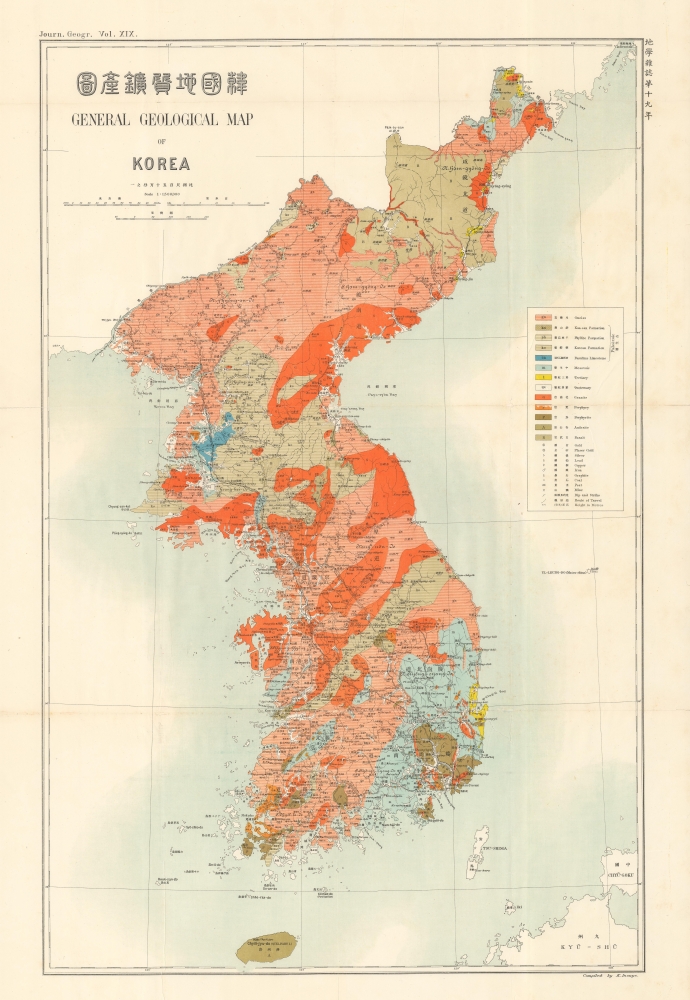
韓國地質礦產圖 / General Geological Map of Korea.
1907 (undated) 30 x 20 in (76.2 x 50.8 cm) 1 : 1500000
1907 (undated) 30 x 20 in (76.2 x 50.8 cm) 1 : 1500000
Description
A richly colorful 1907 geological map of Korea that appeared in the journal Chigaku Zasshi (English title Journal of Geography), published by the Tokyo Geographical Society. It was published at a time when Japan's imperial control of Korea was increasing and Japanese businesses, including mining operations, aimed to rapidly extract Korea's resources to supply Japan's breakneck modernization and industrialization.
The same year this map was published, the Korean 'Emperor' Gojong, long reduced to a figurehead, secretly sent envoys to the Hague Convention on international peace to plead Korea's case and gain support for what little independence the country retained. However, these envoys were refused entry (one subsequently committed suicide as an act of protest) and Japan quickly removed Gojong from the throne, replacing him with his even weaker son Sunjong.
The dominant position of Japanese landowners and businesses in Korea was already established by the time of this map's publication. In the field of mining, Japanese capital and management far outstripped Korean and non-Japanese foreign companies. Gold and silver mining were especially lucrative endeavors in these years. At the same time, Korean guerilla fighters in the countryside incensed by the state of their country undertook hundreds of attacks against Japanese colonists and business interests, including mining companies, a trend that peaked in 1907 - 1908.
A Closer Look
The bright colors employed here denote various geologic strata indicating geologic eras and types of rock. Symbols point to the location of key minerals and metals, mines, and other features. Provinces, towns, cities, and roads are also labeled, including a continuous railway (combining the Gyeongui and Gyeongbu Lines) running southeast to northwest through the peninsula, from Pusan to Seoul, Pyongyang, and finally to Uiju (Wi-jyu) on the Yalu River. The completion of this railway, only the year before this map's publication, was a keystone in solidifying Japan's control of the Korean Peninsula in the wake of the Russo-Japanese War (1904 - 1905).Geology for Empire
Though seemingly innocuous, this map cannot be separated from the context of its production, a time when Japan's control of Korea was expanding exponentially. Beginning with the Treaty of Ganghwa in 1876, Japan, which itself had just embarked on a rapid modernization drive, began to exert greater economic and political influence in Korea, bringing it into conflict with rivals China and Russia. After defeating these competitors in successive wars over Korea, the door was open for Japan to first declare Korea a protectorate (1905) and then annex it outright (1910).The same year this map was published, the Korean 'Emperor' Gojong, long reduced to a figurehead, secretly sent envoys to the Hague Convention on international peace to plead Korea's case and gain support for what little independence the country retained. However, these envoys were refused entry (one subsequently committed suicide as an act of protest) and Japan quickly removed Gojong from the throne, replacing him with his even weaker son Sunjong.
The dominant position of Japanese landowners and businesses in Korea was already established by the time of this map's publication. In the field of mining, Japanese capital and management far outstripped Korean and non-Japanese foreign companies. Gold and silver mining were especially lucrative endeavors in these years. At the same time, Korean guerilla fighters in the countryside incensed by the state of their country undertook hundreds of attacks against Japanese colonists and business interests, including mining companies, a trend that peaked in 1907 - 1908.
Publication History and Census
This map was published by the Tokyo Geographical Society (東京地學協會) in Vol. 19 of its journal Chigaku Zasshi (地學雜誌, Journal of Geography) in 1907 (Meiji 40). A National Diet Library catalog listing attributes it to the Geological Survey of Japan within the Ministry of Agriculture and Commerce (農商務省地質調査所), published as 'Geological Report No. 1 (March 1907)' [「地質要報」第1號 (明治40年3月刊)]. The Nichibunken (International Research Center for Japanese Studies) notes an October 1906 mining investigation report (韓國鑛業調査報告) published by the Ministry of Agriculture and Commerce, which contains this map, likely the original appearance of it. In any event, the map is quite rare, with only the Nichibunken and the National Diet Library holding examples from any origin, and with the map having no known history on the market.Cartographer
The Tokyo Geographical Society (東京地学協会; 1879 - present) is a scholarly society concerned with geography and earth sciences. It is best known for publishing Chigaku Zasshi (地學雜誌, with the English title Journal of Geography), published 1889 - present. Chigaku Zasshi is one of the premier geographical journals in Japan. In its early decades, the society and journal focused on geography and followed the model of journals published by Western geographical societies, especially the British Royal Geographical Society. Its president were members of the Japanese imperial family, but in the postwar period this direct link with the imperial family was broken and presidents have since been prominent scientists. The journal has also expanded its focus to embrace new approaches, technologies, and topics in the postwar period. More by this mapmaker...
Condition
Good. Foxing present, especially at right. Wear along fold lines, with some splitting, archivally reinforced on verso.
References
OCLC 965936462, 1021025453. Edwin H. Gragert, Landownership Under Colonial Rule: Korea's Japanese Experience, 1900-1935 (University of Hawaii Press, 1994). Young-Iob Chung, Korea Under Siege, 1876-1945: Capital Formation and Economic Transformation (Oxford University Press, 2006).