1933 Postal Atlas of China Map of Guangdong (Kwangtung) Province
Kwangtung24-postalatlas-1933$450.00

Title
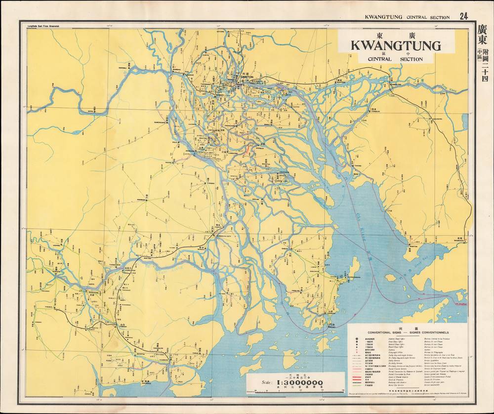
廣東 - 中區 / Kwangtung - Central Section.
1933 (undated) 24.25 x 29 in (61.595 x 73.66 cm) 1 : 3000000
1933 (undated) 24.25 x 29 in (61.595 x 73.66 cm) 1 : 3000000
Description
This is a map of central Guangdong (Kwangtung) Province from the 1933 edition of The Postal Atlas of China (中華郵政輿圖), compiled by Charles Jacot-Guillarmod. It depicts the evolving postal infrastructure, reflecting a broader modernization drive by the Nanjing government.
Presented here is the most densely populated area of Guangdong, the Pearl River Delta, centered on Canton (廣州 Guangzhou). This region has historically been and remains one of the most densely populated places on Earth and a major economic powerhouse, though when this map was issued it also suffered from extreme rural poverty. British Hong Kong is not shown, but was deeply connected to this region, including by railway via the Kowloon-Canton Railway at Shenzhen (深圳 here Shumchün). Portuguese Macao (澳門) near bottom-center was also an important source of economic and cultural exchange with the outside world. Toishan (台山, or Taishan) towards bottom-left was the hometown of most Chinese emigrants to the United States and Canada in the mid-late 19th century.
Guangdong played a central role in Chinese politics in the Republican period (1912 – 1949), when this map was made. The province was the homeland of Sun Yat-sen (1866 – 1925) and many other leading revolutionaries and intellectuals of the period, including Kang Youwei (1858 – 1927) and Liang Qichao (1873 – 1929). It also was a base for residual Republicanism after the national government based in Beijing moved towards autocracy and was a hotbed of anti-imperialist nationalism and radicalism in the 1920s as the nascent Communist movement took hold in China.
After the purging of Communists, Chiang established a new national regime in Nanjing. In the decade that followed, despite weak authority, civil war, a Communist insurgency, and an incremental Japanese invasion of northern China, the Nanjing Government and the Kuomintang (KMT) were able to build something akin to modern, functioning bureaucratic state, particularly in the Lower Yangzi Delta around Nanjing and Shanghai, and successfully completed a range of hallmark infrastructure and modernization projects. Nevertheless, full-scale war with Japan in 1937 derailed these efforts, leading ultimately to Chiang's retreat to Taiwan and the Communist takeover of mainland China.
The second edition of the Postal Atlas was issued in 1919 following a Ministry of Education system to standardize the Beijing dialect in all elementary schools throughout China. This led to a resurgence of the Wade system. Nonetheless, in 1931, the French postal co-director Henri Picard-Destelain ordered a return to the Nanking Syllabary. The Chinese Postal System remained under French management until 1943 when the Japanese invaders ousted A. M. Chapelain, the last French head of the China Post.
Linchpin of Southern China
This map is the twenty-fourth in the atlas' series. The markings indicated in the legend give a great deal of information about the postal and transportation infrastructure in China, including indicating the frequency of service along various routes. The numbers along the routes represent distance using Chinese li (里), equivalent to roughly 500 meters.Presented here is the most densely populated area of Guangdong, the Pearl River Delta, centered on Canton (廣州 Guangzhou). This region has historically been and remains one of the most densely populated places on Earth and a major economic powerhouse, though when this map was issued it also suffered from extreme rural poverty. British Hong Kong is not shown, but was deeply connected to this region, including by railway via the Kowloon-Canton Railway at Shenzhen (深圳 here Shumchün). Portuguese Macao (澳門) near bottom-center was also an important source of economic and cultural exchange with the outside world. Toishan (台山, or Taishan) towards bottom-left was the hometown of most Chinese emigrants to the United States and Canada in the mid-late 19th century.
Guangdong played a central role in Chinese politics in the Republican period (1912 – 1949), when this map was made. The province was the homeland of Sun Yat-sen (1866 – 1925) and many other leading revolutionaries and intellectuals of the period, including Kang Youwei (1858 – 1927) and Liang Qichao (1873 – 1929). It also was a base for residual Republicanism after the national government based in Beijing moved towards autocracy and was a hotbed of anti-imperialist nationalism and radicalism in the 1920s as the nascent Communist movement took hold in China.
The Nanjing Decade
Nanjing became the capital city of China in 1927-28, following the partial reunification of the country by Chiang Kai-Shek's (1887 - 1975) forces in the Northern Expedition. A key turning point in this effort was the Shanghai 'White Terror' of April 1927, when Chiang enlisted the criminal Green Gang to murder Communist agents and activists who had called a general strike in the city. This marked a definitive break between the Nationalists and Communists, who had been cooperating in an uneasy alliance to unify the country up to that point.After the purging of Communists, Chiang established a new national regime in Nanjing. In the decade that followed, despite weak authority, civil war, a Communist insurgency, and an incremental Japanese invasion of northern China, the Nanjing Government and the Kuomintang (KMT) were able to build something akin to modern, functioning bureaucratic state, particularly in the Lower Yangzi Delta around Nanjing and Shanghai, and successfully completed a range of hallmark infrastructure and modernization projects. Nevertheless, full-scale war with Japan in 1937 derailed these efforts, leading ultimately to Chiang's retreat to Taiwan and the Communist takeover of mainland China.
The Postal Atlas of China (中華郵政輿圖)
Compiled by Charles Jacot-Guillarmod, this atlas contains maps covering all of China in considerable detail. Most were derived from regional working postal maps. The legends on the maps are written in English, Chinese, and French. The history of the The Postal Atlas of China is closely related to attempts to Romanize placenames in the Chinese Postal System. The first atlas followed the 1906 Shanghai Imperial Postal Joint-Session Conference to develop a system of Romanization following Herbert Giles' 'Nanking Syllabary.' The Giles 'Nanking syllabary' was popular with the French-dominated Chinese Postal Service, which considered the earlier Beijing based system developed by Thomas Francis Wade as too Anglophone. As was the case for other bureaucratic offices at this time, foreign advisors were often brought in as consultants or even government officials.The second edition of the Postal Atlas was issued in 1919 following a Ministry of Education system to standardize the Beijing dialect in all elementary schools throughout China. This led to a resurgence of the Wade system. Nonetheless, in 1931, the French postal co-director Henri Picard-Destelain ordered a return to the Nanking Syllabary. The Chinese Postal System remained under French management until 1943 when the Japanese invaders ousted A. M. Chapelain, the last French head of the China Post.
Publication History and Census
There are four known editions of this atlas: 1907-08 (Shanghai, replacing the 1903 postal wall map, 21 maps plus index map), 1919 (Beijing, 47 maps), 1933 (Nanjing), and 1936 (Nanjing). The atlas was compiled by the French topographical engineer Charles Jacot-Guillarmod and published by the Directorate General of Posts (郵政總局). This edition is held by a handful of university libraries and research institutions in North America and Europe, as well as institutions in mainland China and Taiwan.Cartographer
Charles Jacot-Guillarmod (1868 – August 14, 1925) was a Swiss topographical engineer active in the late 19th and early 20th century. Charles was born in Le Chaux-de-Fonds, in the Canton of Neuchatel, Switzerland. He attended the Eidgenössische Technische Hochschule Zürich (ETHZ), where he acquired a degree in Topographical Engineering. After graduating served the Swiss Federal Topographical Bureau from 1890 – 1914, contributed significantly to the Topographical Atlas of Switzerland. He was dismissed from his government topographical posted in 1914. Independent of a paid post he turned his attentions to his interested in high alpine cartography, producing two topographical sketches of Himalayan peaks (K2 and Kanchenjunga) based upon photographs taken by his cousin, the famed mountaineer Jules Jacot-Guillarmod. From 1916 to 1922 he relocated to Beijing where he taught geodesy and topography at the Chinese Army Survey School. There, he was also contracted to compile the 1919 second edition of the China Postal Atlas. When the Chinese government could no longer pay him, he returned to Switzerland in 1923 where he compiled a large scale topographic map of Mount Olympus. His final work was a large scale map of Mount Everest commissioned by the Royal Geographical Society, London, based upon the surveying achievements of a British expedition. More by this mapmaker...
Condition
Very good. Light dampstaining periodically, especially at bottom margin.
References
OCLC 5371414, 17468267.