1945 U.S. Army 'Special Strike Map' Kyushu w/ Manuscript Flight Path of Nagasaki Bombing
Kyushu-69thengrtopoco-1945$75,000.00

Title
Kyushu.
1945 (dated) 28.25 x 21.75 in (71.755 x 55.245 cm) 1 : 500000
1945 (dated) 28.25 x 21.75 in (71.755 x 55.245 cm) 1 : 500000
Description
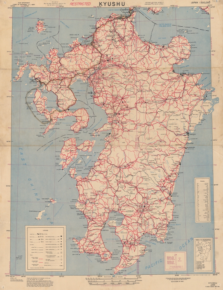
Recording one of the most significant moments in the 20th century, this is a 1945 U.S. Army Corps of Engineers 'Special Strike Map' of Kyushu, Japan, featuring manuscript notations tracing the inbound flight path of Bockscar during 'Fat Man' atomic bombing attack on Nagasaki, Japan, on August 9, 1945. This map was likely used by Bockscar's in-flight navigator James Van Pelt (1918 - 1994) to redirect the mission from the primary target, Kokura, to the secondary target, Nagasaki.
It was acquired from the collections of U.S. Military Museum of Danbury, a private museum owned by John Valluzzo that closed in 2016 after his untimely death. A very similar map with documentation recording comparatively straight-forward Enola Gay track to and from Hiroshima sold at Christie's for USD 72,000 USD in 2005.
At the outset, the mission's primary target was the military-industrial center of Kokura (situated here at the top of the map), but due to smoke and ash Bockscar was unable to get a clear line of sight. Instead, amidst radio silence, it redirected to the secondary target, Nagasaki. A manuscript line follows a course from Kokura south towards Nagasaki - generally following the double-track railroad - an easy line-of-sight navigational guide. It splits just above Hidelsu with one branch toward Sasebo and over the water and the other heading over the 'Kyūshū fighter fields' to Nagasaki. As is discussed later in this description, both courses were considered, but due to fuel concerns, the shorter overland route was chosen.
Both the Hiroshima bomb, 'Little Boy', and the Nagasaki bomb, 'Fat Man', were sent partially assembled to a U.S. airbase on Tinian Island, Marianas, where scientists reassembled the bombs on site. When assembling Fat Man, several key parts were installed incorrectly and so these parts had to be replaced before the mission. This work was finished only hours before Bockscar (an Army B-29 Superfortress) was scheduled to take off.
During the preflight briefing, Bockscar's normal pilot was replaced by one of Colonel Paul Tibbet's friends, Major Charles W. Sweeney - with the idea that he would receive 'everlasting glory'. Though competent, Sweeney was a less field-experienced pilot than the original pilot. Next, during Bockscar's preflight checks, the fuel pump on the reserve tank proved faulty. Even on a normal mission, without an atomic bomb, a faulty fuel pump would have been sufficient to cancel. Nonetheless, command chose to proceed without access to the reserve fuel. Bockscar took off for Japan, followed by two B-29s, The Great Artiste, carrying blast measurement instruments, and Big Stink, carrying photographic equipment. The three aircraft were supposed to connect over Yakushima, but Big Stink, flying too high, missed the rendezvous. Sweeney and Bockscar waited 45 minutes for Big Stink, instead of the ordered 15, leading to a further fuel shortage.
Bockscar proceeded to its primary target: Kokura. On arrival, they found heavy clouds obscuring Kokura, restricting the line of sight making an accurate bomb drop impossible. After three failed runs, which expended more fuel and brought intense anti-aircraft fire as well as the possibility of approaching Japanese fighters, Bockscar redirected to the secondary target, Nagasaki, some 95 miles south. At the time, they were operating under radio silence and could navigate only by line of sight with limited available maps. Moreover, without a reserve tank and already depleted fuel, Bockscar had to take the most direct overland route to Nagasaki, forcing it to fly over the Kyūshū fighter fields, instead the safer route swinging out over the East China Sea. (https://www.peace-nagasaki.go.jp/abombrecords/b020103.html). As the plan here indicates, Van Pelt had to considerer several possible routes, taking into account hostile territory, the volatility of the cargo, and the drastic fuel shortage. Moreover, he was operating under radio silence, so could rely only on visual line of sight cues to navigate. As the manuscript here suggests, this map tracks routes along major double-track railroads, or large islands, easily seen and identified from the sky. Curiously, it also highlights Sasebo, a major Japanese naval port. Although not officially considered as a target, one wonders if the flight crew might have considered making it a 'target of opportunity' given their fuel shortage.
Accounts from Nagasaki differ about whether one or two planes appeared over the city and from what direction they came, but according to post-operation interviews, both planes remained together the entire time. At 12:02 PM 'Fat Man' detonated over Nagasaki at 1,840 feet above the city releasing a blast equivalent to 22,000 tons of TNT. After the attack, knowing they were very low on fuel, Bockscar and The Great Artiste headed for the recently seized island of Okinawa, where both landed precariously, Bockscar fully out of fuel. Big Stink arrived at Okinawa a few hours later after photographing Nagasaki. Later that afternoon all three planes returned to Tinian.
Authenticity, Provenance, and Assumptions
Although we firmly believe the map to be Bockscar's in-flight map, with manuscript annotation by navigator James Van Pelt, it has no corroborating documentation - as is consistent with the post-operation coverup. Nonetheless, as a 'Restricted' 'Special Strike Map' issued shortly before the bombing, it represents the most up to date military mapping of Kyushu available to in-flight navigators. The map, with its multiple manuscript flight paths, generally following major railroads, is consistent with the ambiguity of re-structuring the goal and flight-path mid-mission over hostile territory, with consideration given to a crisis-level fuel shortage. This map, even without manuscript annotation, is extremely rare, having had a low print run, an ephemeral relevant lifespan, been restricted, and thus survives in only a few examples - we are aware of just one other.It was acquired from the collections of U.S. Military Museum of Danbury, a private museum owned by John Valluzzo that closed in 2016 after his untimely death. A very similar map with documentation recording comparatively straight-forward Enola Gay track to and from Hiroshima sold at Christie's for USD 72,000 USD in 2005.
A Panoply of Error
By any measure, the dropping of the second atomic bomb 'Fat Man' on Nagasaki was ill-fated. Mistakes, mechanical issues, a breakdown of command, poor decision making, and inclement weather all had a part to play. Unlike the Enola Gay, which returned from Hiroshima to fanfare and praise, Bockscar returned from Nagasaki to face sharp criticism, talk of courts martial, and a broad military coverup intended to conceal a string of embarrassing mishaps under the sheen of an ultimately successful mission. It is therefore unsurprising the log of Bockscar navigator James Van Pelt, as well as other data, mysteriously vanished in the immediate wake of the mission.The Flight Paths
Records of the Nagasaki bombing were intentionally suppressed and remain steeped in confusion, particularly regarding the flight path taken by Bockscar. What little we know of the flight path, is what can be deduced from the interviews with the crew and ground reports from observers in Japan. These are remarkably conflicting, with some eye-witness accounts pointing to a single plane appearing over Takashimamachi (island southwest of Nagasaki), others reporting seeing two planes flying over the Ariake Sea, and still others reporting a single plane approaching between Iwayasan (岩屋山) and Mt. Konpira (金比羅山).At the outset, the mission's primary target was the military-industrial center of Kokura (situated here at the top of the map), but due to smoke and ash Bockscar was unable to get a clear line of sight. Instead, amidst radio silence, it redirected to the secondary target, Nagasaki. A manuscript line follows a course from Kokura south towards Nagasaki - generally following the double-track railroad - an easy line-of-sight navigational guide. It splits just above Hidelsu with one branch toward Sasebo and over the water and the other heading over the 'Kyūshū fighter fields' to Nagasaki. As is discussed later in this description, both courses were considered, but due to fuel concerns, the shorter overland route was chosen.
The Second Atomic Bombing: August 9, 1945, Nagasaki, Japan
While the first atomic bombing, Hiroshima (August 6, 1945), proceeded without incident, the mission that bombed Nagasaki was plagued by mishaps. Originally planned for August 11, the mission was moved up to August 9 due to reports of an incoming typhoon. This sped up timeline can be blamed for some but not all of the mission's problems.Both the Hiroshima bomb, 'Little Boy', and the Nagasaki bomb, 'Fat Man', were sent partially assembled to a U.S. airbase on Tinian Island, Marianas, where scientists reassembled the bombs on site. When assembling Fat Man, several key parts were installed incorrectly and so these parts had to be replaced before the mission. This work was finished only hours before Bockscar (an Army B-29 Superfortress) was scheduled to take off.
During the preflight briefing, Bockscar's normal pilot was replaced by one of Colonel Paul Tibbet's friends, Major Charles W. Sweeney - with the idea that he would receive 'everlasting glory'. Though competent, Sweeney was a less field-experienced pilot than the original pilot. Next, during Bockscar's preflight checks, the fuel pump on the reserve tank proved faulty. Even on a normal mission, without an atomic bomb, a faulty fuel pump would have been sufficient to cancel. Nonetheless, command chose to proceed without access to the reserve fuel. Bockscar took off for Japan, followed by two B-29s, The Great Artiste, carrying blast measurement instruments, and Big Stink, carrying photographic equipment. The three aircraft were supposed to connect over Yakushima, but Big Stink, flying too high, missed the rendezvous. Sweeney and Bockscar waited 45 minutes for Big Stink, instead of the ordered 15, leading to a further fuel shortage.
Bockscar proceeded to its primary target: Kokura. On arrival, they found heavy clouds obscuring Kokura, restricting the line of sight making an accurate bomb drop impossible. After three failed runs, which expended more fuel and brought intense anti-aircraft fire as well as the possibility of approaching Japanese fighters, Bockscar redirected to the secondary target, Nagasaki, some 95 miles south. At the time, they were operating under radio silence and could navigate only by line of sight with limited available maps. Moreover, without a reserve tank and already depleted fuel, Bockscar had to take the most direct overland route to Nagasaki, forcing it to fly over the Kyūshū fighter fields, instead the safer route swinging out over the East China Sea. (https://www.peace-nagasaki.go.jp/abombrecords/b020103.html). As the plan here indicates, Van Pelt had to considerer several possible routes, taking into account hostile territory, the volatility of the cargo, and the drastic fuel shortage. Moreover, he was operating under radio silence, so could rely only on visual line of sight cues to navigate. As the manuscript here suggests, this map tracks routes along major double-track railroads, or large islands, easily seen and identified from the sky. Curiously, it also highlights Sasebo, a major Japanese naval port. Although not officially considered as a target, one wonders if the flight crew might have considered making it a 'target of opportunity' given their fuel shortage.
Accounts from Nagasaki differ about whether one or two planes appeared over the city and from what direction they came, but according to post-operation interviews, both planes remained together the entire time. At 12:02 PM 'Fat Man' detonated over Nagasaki at 1,840 feet above the city releasing a blast equivalent to 22,000 tons of TNT. After the attack, knowing they were very low on fuel, Bockscar and The Great Artiste headed for the recently seized island of Okinawa, where both landed precariously, Bockscar fully out of fuel. Big Stink arrived at Okinawa a few hours later after photographing Nagasaki. Later that afternoon all three planes returned to Tinian.
Publication History and Census
This map was originally prepared by the 69th Engineer Topographic Company in July 1945 and compiled from Army maps of Japan from 1944 and 1945. The present map was printed by Base Map Plant No. 1, General Headquarters, AFPAC (U.S. Army Forces in the Pacific) in August 1945 - making it the most up to date map available for bombing missions on Kyushu. We are aware of only one other example of the present map, held in private hands. The manuscript additions make this piece unique, and doubtless further study of it will shed new light on one the most pivotal moments in human history.Condition
Very good.