This item has been sold, but you can get on the Waitlist to be notified if another example becomes available.
1957 U.S. Coast Survey Aeronautical Chart of Los Angeles, California and Environs
LAAeronauticalChart-uscs-1957$225.00


Title
Los Angeles Sectional Aeronautical Chart. 43rd Edition. U. S. Air Force Edition.
1957 (dated) 23 x 48.5 in (58.42 x 123.19 cm) 1 : 500000
1957 (dated) 23 x 48.5 in (58.42 x 123.19 cm) 1 : 500000
Description
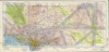
An impressive, large-format aeronautical chart of the Los Angeles metro area, prepared in 1957 by the U.S. Coast and Geodetic Survey for the U. S. Air Force. The map records Los Angeles' pioneering contributions to early American aviation.
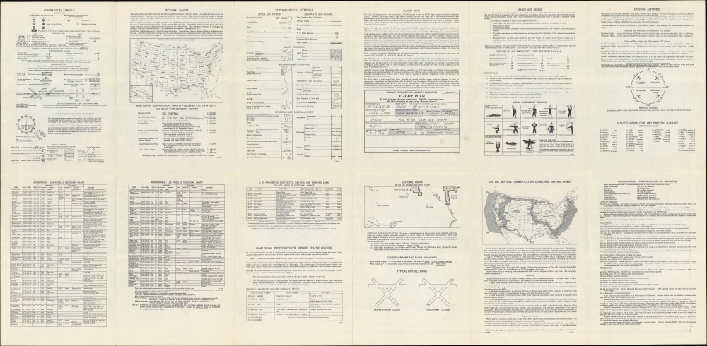
The verso includes legends explaining aeronautical and topographical symbols used throughout the chart, a complete list of aerodromes included on the recto, an index map of the sectional aeronautical charts covering the entire U.S., prohibited and restricted areas, a map of the U.S. with Air Defense Identification Zones indicated, information on radio frequencies, emergency signals, cruising altitudes, and more. Handwritten annotations on the recto signify that this chart saw actual use aboard an airplane, with flights between Air Force airfields and Compton's Woodley Airport.
A Closer Look
Ranging from California's Central Valley and Las Vegas (McCarran Field) at top to Long Beach and Palm Springs at bottom, this chart covers a vast portion of Southern California, along with portions of Arizona and Nevada, including Bakersfield, Santa Barbara, and Los Angeles. Civilian and military airports are labeled throughout, connected by flightpaths shaded purple (civilian) and red (military). Private airfields are also noted, including the private Hughes Airport, used by Howard Hughes and the Hughes Aircraft Company, in Culver City. To its south is Los Angeles International Airport (LAX), which at this time was severely in need of an overhaul, as 'temporary' facilities built immediately after World War II (1939 - 1945) had far outlived their intended lifespan and were incapable of meeting the increased demand for commercial air travel in Los Angeles. Much of the northern portion of the chart is marked 'restricted,' as they included essential military airfields and related facilities, including the Naval Ordnance Test Station at China Lake, where key rockets and missiles of the early Cold War era were developed.The verso includes legends explaining aeronautical and topographical symbols used throughout the chart, a complete list of aerodromes included on the recto, an index map of the sectional aeronautical charts covering the entire U.S., prohibited and restricted areas, a map of the U.S. with Air Defense Identification Zones indicated, information on radio frequencies, emergency signals, cruising altitudes, and more. Handwritten annotations on the recto signify that this chart saw actual use aboard an airplane, with flights between Air Force airfields and Compton's Woodley Airport.
Los Angeles and the Early History of Aviation
Los Angeles and Southern California played a significant role in the early history of aviation. The climate, the ready availability of land for airstrips, the presence of relevant educational institutions (especially the California Institute of Technology), and the business-friendly climate of Los Angeles were especially attractive for aviation pioneers, with Dominguez Field hosting the Los Angeles International Air Meet in 1910, the first major airshow in the United States. In the following years, numerous aviation companies were founded in Southern California, including the Lockheed Aircraft Company, the Northrup Corporation, the Douglas Aircraft Company, and the Hughes Aircraft Company. The Second World War provided extensive funds and personnel to these companies, which continued into the Cold War period, as jet engines and other new technologies developed, allowing aviation and aerospace to become major industries in the economy of Southern California.Publication History and Census
This chart was prepared by the U.S. Coast and Geodetic Survey for the U.S. Air Force in 1957. It is the 43rd edition of the U.S.C.S. Los Angeles Sectional Aeronautical Chart, which was frequently updated to reflect the addition of new airfields (including military ones) and other changes that were common in these years. The present edition is not independently cataloged in the OCLC, while the 41st edition (1956) is noted as being held by Stanford University.Cartographer
The Office of the Coast Survey (1807 - present) founded in 1807 by President Thomas Jefferson and Secretary of Commerce Albert Gallatin, is the oldest scientific organization in the U.S. Federal Government. Jefferson created the "Survey of the Coast," as it was then called, in response to a need for accurate navigational charts of the new nation's coasts and harbors. The spirit of the Coast Survey was defined by its first two superintendents. The first superintendent of the Coast Survey was Swiss immigrant and West Point mathematics professor Ferdinand Hassler. Under the direction of Hassler, from 1816 to 1843, the ideological and scientific foundations for the Coast Survey were established. These included using the most advanced techniques and most sophisticated equipment as well as an unstinting attention to detail. Hassler devised a labor intensive triangulation system whereby the entire coast was divided into a series of enormous triangles. These were in turn subdivided into smaller triangulation units that were then individually surveyed. Employing this exacting technique on such a massive scale had never before been attempted. Consequently, Hassler and the Coast Survey under him developed a reputation for uncompromising dedication to the principles of accuracy and excellence. Unfortunately, despite being a masterful surveyor, Hassler was abrasive and politically unpopular, twice losing congressional funding for the Coast Survey. Nonetheless, Hassler led the Coast Survey until his death in 1843, at which time Alexander Dallas Bache, a great-grandson of Benjamin Franklin, took the helm. Bache was fully dedicated to the principles established by Hassler, but proved more politically astute and successfully lobbied Congress to liberally fund the endeavor. Under the leadership of A. D. Bache, the Coast Survey completed its most important work. Moreover, during his long tenure with the Coast Survey, from 1843 to 1865, Bache was a steadfast advocate of American science and navigation and in fact founded the American Academy of Sciences. Bache was succeeded by Benjamin Pierce who ran the Survey from 1867 to 1874. Pierce was in turn succeeded by Carlile Pollock Patterson who was Superintendent from 1874 to 1881. In 1878, under Patterson's superintendence, the U.S. Coast Survey was reorganized as the U.S. Coast and Geodetic Survey (C & GS) to accommodate topographic as well as nautical surveys. Today the Coast Survey is part of the National Oceanic and Atmospheric Administration or NOAA as the National Geodetic Survey. More by this mapmaker...
Condition
Very good. Light wear along original folds. Text on verso.
References
OCLC 992513960 (earlier edition).