1757 Bellin Map of the Great Lakes
LacsDuCanada-bellin-1757-3$950.00

Title
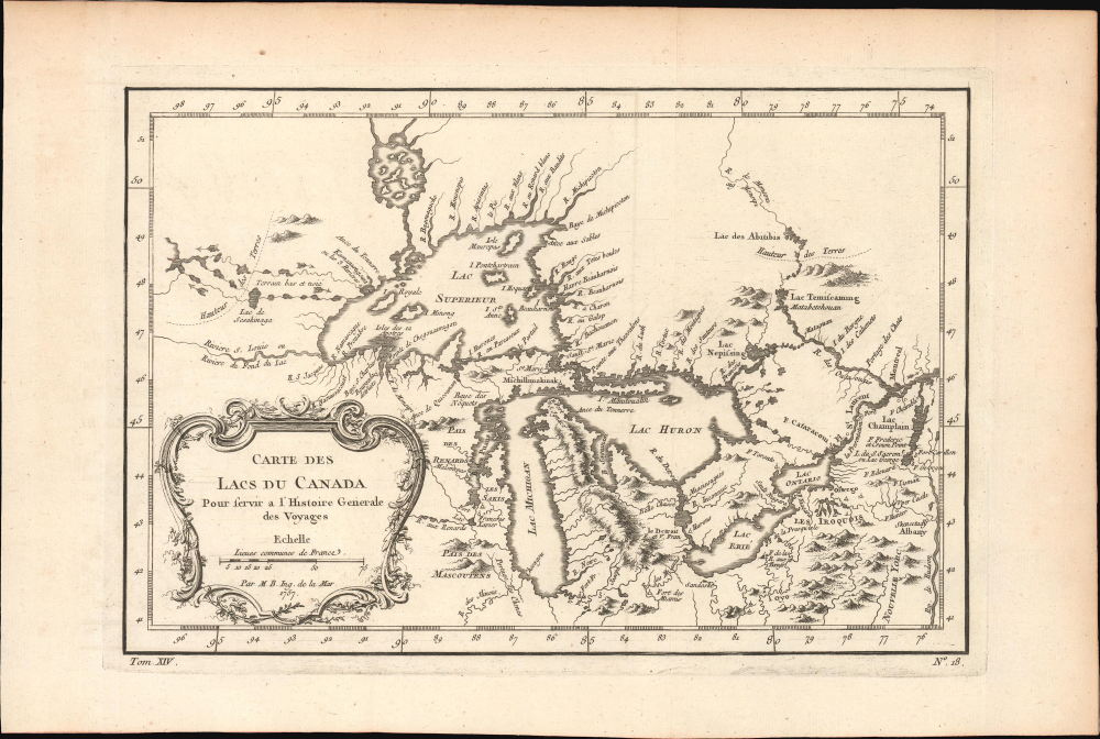
Carte des Lacs du Canada.
1757 (dated) 8 x 11.5 in (20.32 x 29.21 cm) 1 : 6500000
1757 (dated) 8 x 11.5 in (20.32 x 29.21 cm) 1 : 6500000
Description
This elegant map of the Great Lakes, printed in 1757 for Abbe Provost's L'Histoire Generale des Voyages, was drawn by French cartographer Jacques-Nicholas Bellin. It is also notable for being among the earliest maps to identify Detroit and the Port of Chicago (Checagou). Significantly, Bellin's cartography was one of the first to depict the four phantom islands in Lake Superior (Philippeux, Pontchartrain, Maurepas, and St. Anne) - islands that, despite their nonexistence, influenced the structuring of post-Revolutionary War borders between British Canada and the fledgling United States.
Bellin based this map substantially on the work of the French fur trader and explorer Pierre Gaultier de Varennes et de La Vérendrye (1685 - 1739) and the explorer-missionary Pierre François Xavier de Charlevoix (1682 -1761), allowing Bellin to synthesize a model of the Great Lakes superior to that proposed by De L'Isle, considered the best mapping of the region in the first part of the century. Bellin relies on Verendrye's journals with regard to the placement of numerous Indian nations and villages.
It was Charlevoix who invented the four spurious islands in Lake Superior: Philippeaux, Pontchartrain, Maurepas, and St. Anne. The islands were named to honor Charlevoix's personal patron, the Count of Maurepas, Jean-Frederic Phelypeaux (1701 - 1781). The largest of the three islands, Philippeaux, is named after the count. The second largest island, Pontchartrain, refers to Phelypeaux's family estate. The third island, which may be a mismapping of the factual State Island, is named after the count's seat, Maurepas. The fourth and smallest of the islands, St. Anne, references the count's patron saint. Charlevoix described the islands as being rich in minerals, leading explorers to search them in vain. Bellin dutifully introduced the islands to his map, offered here, and such was his influence that they were subsequently copied by most subsequent cartographers, including John Mitchell in his seminal 1755 wall map of North America. The highly regarded Mitchell map was used in negotiating the 1783 Treaty of Paris that formally concluded the American Revolutionary War (1775 - 1783). Therein, the apocryphal Philippeaux was assigned as a marker for the new United States - British America border thus setting the stage for later political strife.
A Closer Look
This is a smaller-format version of Bellin's foundational 1744 map of the region, representing the state-of-the-art of Great Lakes mapping for the 18th century. Coverage embraces the Great Lakes as well as adjacent Indian lands and the English colonies of Pennsylvania, New Jersey, and New York. The Great Lakes' drainage system is detailed with fortifications, American Indian villages, missions, and some speculative topography (particularly in Michigan). Modern-day Lake Nipigon, sometimes referred to as the Sixth Great Lake, is also included.Bellin based this map substantially on the work of the French fur trader and explorer Pierre Gaultier de Varennes et de La Vérendrye (1685 - 1739) and the explorer-missionary Pierre François Xavier de Charlevoix (1682 -1761), allowing Bellin to synthesize a model of the Great Lakes superior to that proposed by De L'Isle, considered the best mapping of the region in the first part of the century. Bellin relies on Verendrye's journals with regard to the placement of numerous Indian nations and villages.
It was Charlevoix who invented the four spurious islands in Lake Superior: Philippeaux, Pontchartrain, Maurepas, and St. Anne. The islands were named to honor Charlevoix's personal patron, the Count of Maurepas, Jean-Frederic Phelypeaux (1701 - 1781). The largest of the three islands, Philippeaux, is named after the count. The second largest island, Pontchartrain, refers to Phelypeaux's family estate. The third island, which may be a mismapping of the factual State Island, is named after the count's seat, Maurepas. The fourth and smallest of the islands, St. Anne, references the count's patron saint. Charlevoix described the islands as being rich in minerals, leading explorers to search them in vain. Bellin dutifully introduced the islands to his map, offered here, and such was his influence that they were subsequently copied by most subsequent cartographers, including John Mitchell in his seminal 1755 wall map of North America. The highly regarded Mitchell map was used in negotiating the 1783 Treaty of Paris that formally concluded the American Revolutionary War (1775 - 1783). Therein, the apocryphal Philippeaux was assigned as a marker for the new United States - British America border thus setting the stage for later political strife.
Publication History and Census
The present edition was drawn by Jacques Nicolas Bellin and published as plate no. 18 in volume 9 of the 1757 French edition of Abbe Provost's L'Histoire Generale des Voyages. This work has a long publication history and is well-represented in institutional collections. The map appears on the market from time to time.Cartographer
Jacques-Nicolas Bellin (1703 - March 21, 1772) was one of the most important cartographers of the 18th century. With a career spanning some 50 years, Bellin is best understood as geographe de cabinet and transitional mapmaker spanning the gap between 18th and early-19th century cartographic styles. His long career as Hydrographer and Ingénieur Hydrographe at the French Dépôt des cartes et plans de la Marine resulted in hundreds of high quality nautical charts of practically everywhere in the world. A true child of the Enlightenment Era, Bellin's work focuses on function and accuracy tending in the process to be less decorative than the earlier 17th and 18th century cartographic work. Unlike many of his contemporaries, Bellin was always careful to cite his references and his scholarly corpus consists of over 1400 articles on geography prepared for Diderot's Encyclopedie. Bellin, despite his extraordinary success, may not have enjoyed his work, which is described as "long, unpleasant, and hard." In addition to numerous maps and charts published during his lifetime, many of Bellin's maps were updated (or not) and published posthumously. He was succeeded as Ingénieur Hydrographe by his student, also a prolific and influential cartographer, Rigobert Bonne. More by this mapmaker...
Source
Prévost, A., Histoire Générale des Voyages, ou Nouvelle Collection de Toutes les Relations de Voyages par Mer et par Terre..., (Paris: Didot) 1746 - 1759, Supplements 1761 - 1801.
Prévost's Histoire Générale des Voyages is a 15-volume compendium of travel literature initiated by Antoine François Prévost (Provost; 1697 - 1763) in 1746, intended as a universal history of exploration and geography. The initial publication, compiled from 1746 to 1759, spans 15 volumes and draws from a vast array of sources - travelers, explorers, missionaries, merchants, and diplomats - to present detailed narratives of significant global journeys. The work was initially published in Paris by Didot and offers ethnographic, political, religious, and natural observations about the peoples, cultures, flora, fauna, and geography. It is an ambitious attempt to organize knowledge about the world's diversity according to Enlightenment values, reflecting both scientific curiosity and imperial ideology. It functioned as both an informative reference and a literary work, influencing how European audiences understood and imagined distant lands. It proved extremely successful, and both reissues other publishers and pirate editions emerged, most notably Pierre de Hondt's 1747 Dutch edition and Jean-Franćois de la Harpe's 1780 abridged version. In addition to reissues of the original work, between 1768 and 1801, additional expanded volumes emerged, adding new voyages and histories. We have seen some sets with as many as 80 volumes. Over time, the Histoire générale des voyages became one of the most comprehensive and widely read travel collections of the 18th century, notable for blending factual reporting with the period's characteristic intellectual ambition.
Condition
Very good. Minor wear along original fold lines. Minor toning and offsetting, with some foxing at places. Original platemark visible. Minor creasing along left border with part of lower left margin missing.
References
OCLC 80491524.