This item has been sold, but you can get on the Waitlist to be notified if another example becomes available, or purchase a digital scan.
1728 Van der Aa and Map of Asia or Tartary
LaGrandeTartarie-vanderaa-1728$175.00

Title
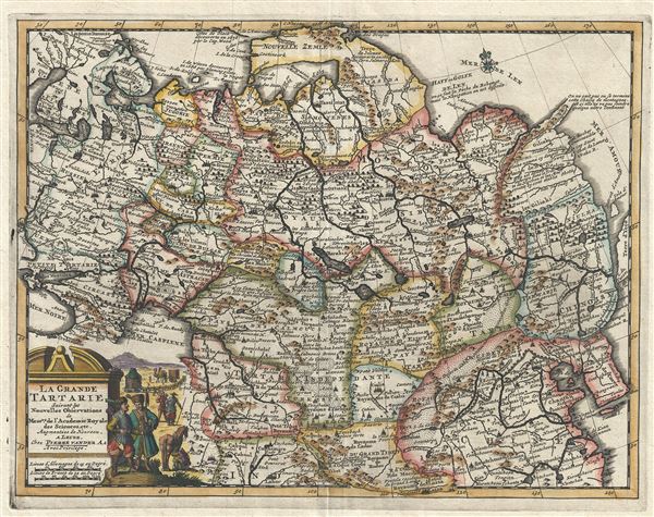
La Grande Tartarie Suivant les Nouvelles Observations de Messrs. De l'Academie Royale des Sciences, etc.
1728 (dated) 9.5 x 12.5 in (24.13 x 31.75 cm) 1 : 23000000
1728 (dated) 9.5 x 12.5 in (24.13 x 31.75 cm) 1 : 23000000
Description
A very attractive 1729 map of Asia and Tartary by the Dutch cartographer Pieter van der Aa. Pieter's (or Pierre) map covers from the Black Sea to Korea and from Nova Zembla south as far as Lhasa and Lahor. Although Van der Aa's maps are not known for their originality, they are highly admired for their fine engraving and overall presentation. Here Vander all embraces many of the apocryphal conventions associated with the mapping of Asia in the late 16th and early 17th centuries. These include the attachment of Nova Zembla to the mainland and a particularly dense mapping of Siberia which, for the most part, is speculative. One area of special note is Van der Aa's treatment of the extreme northeast of Asia between the Gulf of Len and Terre d'Yeco (Hokkaido). Of particular interest is the unusual peninsula extending from the Siberian mainland to the northwest with the following note:
A dramatic title cartouche appears in the lower left quadrant bearing illustrations of Tartar life, including camels, mobile yurts, and sturdy steppe ponies.
Published in 1729 for issue in Van der Aa's much admired Nouveau Atlas.
On ne saint pas ou se termine cette Chaine de montagnes et si elle ne va pas joinder quelque autre continent.This oddity appears on numerous maps dating from the late 17th and early 19th century. It is a legacy of Peter the Great's obsession over the search for a Northeast Passage. Around 1648 the Cossack Semen Ivanovich Dezhnyov (1605 - 1673) put together a rough and ready expedition to explore the region. His company consisted of Fedot Alekseyev, traveling with the merchants Andreev and Afstaf'iev (representing the Guselnikov merchant house), who provided their own ship. Gerasim Ankudinov, an experienced sea captain with his own ship and some 30 men. Dezhnev, along with Mikhail Stadukhin recruit some 19 men of his own and procured a traditional kocha ship. Including escort vessels, a total seven ships sailed from the mouth the Kolyma River, along the Siberian Arctic, to the Anadyr River north of Kamchatka, and in doing so became the first Europeans to sail through the Bering Strait some 80 years before Vitus Bering. Dezhnyov described rounding a large mountainous promontory Chukchi, Tschuktschi, or Chukotka Peninsula. Of the seven vessels the multiple leaders, only three ships, and Dezhnev survived the passage. His expedition was mostly forgotten outside of limited cartographic circles until Gerhardt Friedrich Muller discovered Dezhnyov's reports and in 1758 published them. Dezhnyov ultimately proved that there was indeed a nautical route from Russia to Asia, but at the same time confirmed that it was exceedingly impractical for trade. Nonetheless his promontory was subsequently embraced by European cartographers who, lacking serious scientific data from the Dezhnyov expedition, surmised the form. The first of these was Dutchman Nicholaas Witsen, who prepared a map in 1687 based upon Dezhnyov's records that he discovered on a 1665 trip to Moscow. Many cartographers follows suit, though some, like Van der Aa here, even went so far as to suggest that this landmass actually connected to America, and in doing so, both embraced and dismissed Dezhnyov, whose journey provided the first definitive proof that Asia was not connected to America.
It is not known where this mountain chain ends or if it connects to the other continent. (our own translation)
A dramatic title cartouche appears in the lower left quadrant bearing illustrations of Tartar life, including camels, mobile yurts, and sturdy steppe ponies.
Published in 1729 for issue in Van der Aa's much admired Nouveau Atlas.
Cartographer
Pieter van der Aa (1659 - 1733) was a Dutch publisher of maps and atlases active in the late 17th and early 18th centuries. Van der Aa was born in Leyden in 1659. At nine he was apprenticed to a local bookseller and, by 21, had established his own publishing, printing, and auctioneering house. In 1692 Van der Aa was appointed to be one of the High Commissioners of the Booksellers Guild. During his long and impressive career Van der Aa produced thousands of maps, including a vast 28 volume atlas containing no less than 3,000 maps. Few of Van der Aa's maps were original productions, most being copied from the work of earlier cartographers. Nonetheless, when one of Van der Aa's rare original pieces does appear, his style, with unusual projections, elegant engraving, and precise detail, is instantly recognizable and highly desirable. He also pioneered the cartographic idea of separating border artwork from the map plate itself such that every map in a collection could have a similar elaborate border without actually having to re-engrave the complex plates. This technique was used to great effect by later 18th century publishers like Brion de la Tour. Following Van der Aa's death in 1733, his much admired Nouvel Atlas was reissued by the Dutch firm of Covens & Mortier. Today Van der Aa's work is admired for its fine delicate engraving and unusual projections and is considered highly desirable among collectors. More by this mapmaker...
Source
Van der Aa, P., Nouvel Atlas, (Leiden) 1729.
Condition
Very good. Strong impression suggests an early strike off the plate. Blank on verso. Platemark visible.
References
Koeman, Cornelis, Atlantes Neerlandici. Bibliography of Terrestrial, Maritime and Celestial Atlases and Pilot Books, Published in the Netherlands up to 1880, Aa6. OCLC 276567611.