1940 Hagstrom Map of Lake Champlain and New York, Vermont, New Hampshire
LakeChamplain-hagstrom-1940$250.00

Title
Map and Guide to Lake Champlain.
1940 (undated) 16.25 x 21 in (41.275 x 53.34 cm) 1 : 970000
1940 (undated) 16.25 x 21 in (41.275 x 53.34 cm) 1 : 970000
Description
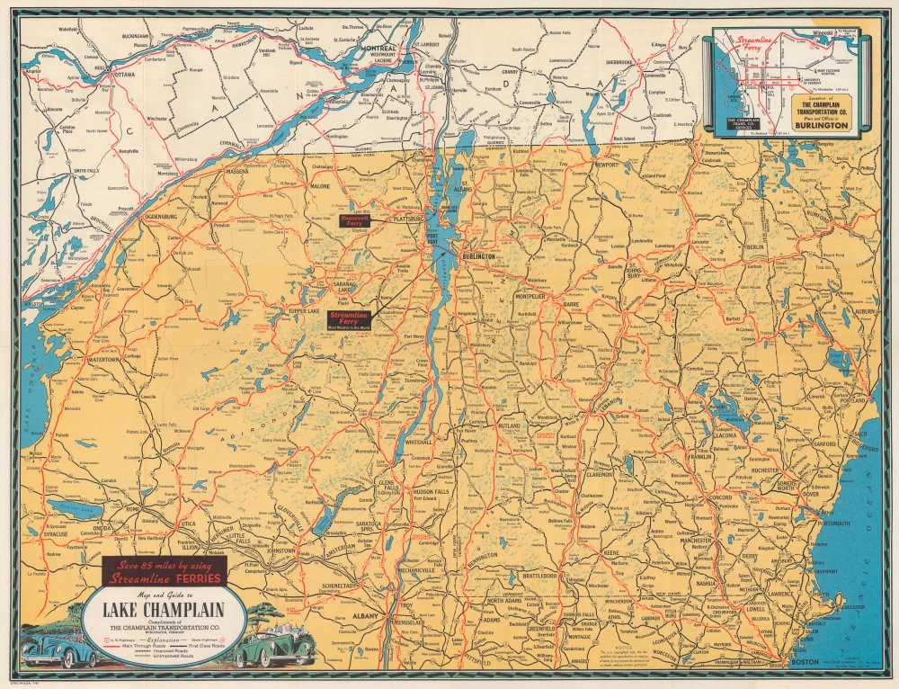
A tourist map published during World War II, this is a 1940 Hagstrom map of Lake Champlain, New York, Vermont, and New Hampshire distributed by the Champlain Transportation Company, which operated steamships on Lake Champlain.
A Closer Look
Depicting from Lake Ontario to Maine and from Montreal to Pittsfield, Massachusetts, cities, towns, and villages are labeled throughout. Arrows mark the routes of the Streamline and Roosevelt Ferries across Lake Champlain. Red and black lines highlight the road network with mileage noted. A small inset in the upper right details Burlington, Vermont, and marks the location of the Champlain Transportation Company office and piers, as well as the University of Vermont and the Mary Fletcher Hospital.Verso Content
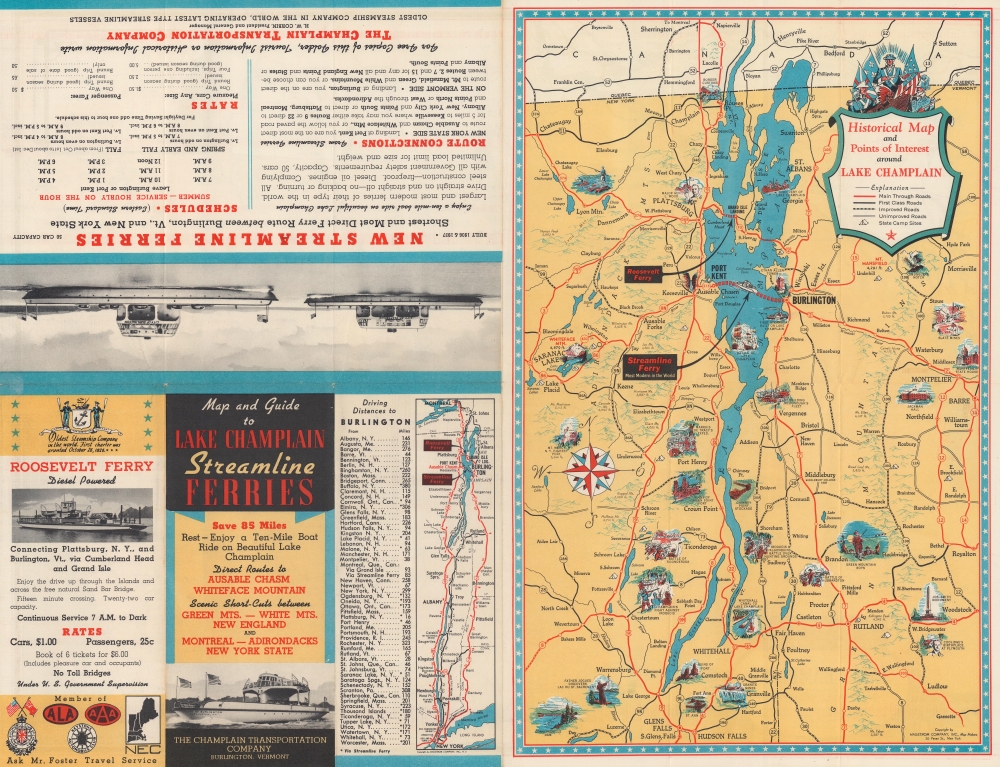
A historical map of Lake Champlain occupies half the verso. Vignettes highlight historic events, including the Green Mountain Boys, the birthplace of President Calvin Coolidge, and several forts. The other half of the sheet provides driving directions and information on ferry crossings.Champlain Transportation Co.
The Lake Champlain Transportation Company is the oldest steamboat company in the United States and remains in operation. The company was founded after opening of the 63-mile canal connecting Lake Champlain to the Hudson River, which connected the region to New York City and all points south. Founded by William A. Griswald, it received its charter on October 26, 1826. The first Lake Champlain steamer, the Franklin, launched shortly thereafter. Eventually it grew to operate multiple steamers, also operating on Lake George. Today, approximately one million people cross Lake Champlain by ferry annually.Publication History and Census
This map was created and published by Hagstrom in 1940 and distributed by the Champlain Transportation Company. We note four examples cataloged in OCLC which are part of the collections at the New York Public Library, the University of Wisconsin Milwaukee, the University of California Los Angeles, and the University of Michigan.Cartographer
Andrew Gunnar Hagstrom (1890 - September 24, 1977) was a map publisher based in Maspeth, Queens. Hagstrom was a Swedish immigrant who came to new York in 1909 where took work milking cows at a farm near Coney Island, Brooklyn. He then worked in the meat packing industry while taking a degree in commercial art at the New York Mechanics Institute. Afterwords he founded a drafting business in Manhattan, creating a map to illustrate his drafting skill help customers locate his shop. His map proved popular and he expanded operations, founding the Hagstrom Map Company (1916 - 1968) and issuing additional maps of various parts of New York City and the surrounding regions. By 1949, Hagstrom had issued more than 150 maps, guides, and atlases, most of which focused on New York. Hagstrom pioneered a cartographic style that exaggerated street size to increase clarity and create additional room for large print readable labeling. Even the New York Subway system hired Hagstrom to produce its map, which was in use from the 1940s to 1958. Hagstrom died in 1977, at the age of 81. Hagstrom was knighted by the King of Sweden. His company flourished until 1968 when it was acquired by Macmillan. The brand has since passed through multiple corporate portfolios and is currently the property by Kappa Publishing Group. More by this mapmaker...
Condition
Very good. Light wear along original fold lines. Verso repair to a fold separation.