
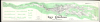
1968 Hunt and Boardman Bathymetic Map of Lake Champlain, Vermont (huge)

This item has been sold.
Lake Champlain Basin Bathymetry.
Massive map of Lake Champlain.
Choose a Collection:
This Item
Enquire
Massive map of Lake Champlain.
This is an impressive 1968 bathymetric map of Lake Champlain, Vermont, compiled by geologists Allan S. Hunt and Craig C. Boardman. It is the largest-scale single map of Lake Champlain of which we are aware.A Closer Look
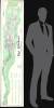
This expansive map measures nearly 90 inches long and is oriented to the west. Coverage embraces the full extent of Lake Champlain from the Richelieu River and Peel Head Bay in Canada to South Bay, in the vicinity of White Hall, roughly parallel to Lake George. Dense bathymetric soundings fill the lake, offering a comprehensive understanding of the submarine topography. The map includes 10 bathymetric cross-sections with a vertical exaggeration of 10 to 1.Publication History and Census
This bathymetric study of Lake Champlain was prepared by Allen S. Hunt and Craig C. Boardman and published in 1968. Hunt is a professor of Geology at the University of Vermont. Craig C. (Cheney?) Boardman is more elusive, though his name is cited in various academic papers relating to Lake Champlain and Vermont geology. Rare. We see examples only at the American Geographical Society Library at the University of Wisconsin, Milwaukee, and at Middlebury College.Source
Champlain Research Reports, (Burlington: University of Vermont) 1968.
Condition
Very good. Laid down on original linen. Some old fold lines.
References
University of Wisconsin, Milwaukee, American Geographical Society Library, Maps 862-c.C4L3 H-1968. OCLC 61331923. Middlebury College, G3802.C45 C2 1968 H85.