This item has been sold, but you can get on the Waitlist to be notified if another example becomes available, or purchase a digital scan.
1623 Hondius Map of Lake Geneva, Switzerland
LakeGeneva-hondius-1606$425.00

Title
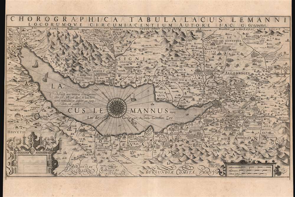
Chorographica Tabula Lacus Lemanni Locorumque Circumiacentium Auctore Iac. G. Genevensi.
1606 (undated) 12 x 21.25 in (30.48 x 53.975 cm) 1 : 70000
1606 (undated) 12 x 21.25 in (30.48 x 53.975 cm) 1 : 70000
Description
An uncommon and beautiful map of Lake Geneva engraved by Jodocus Hondius for inclusion in his 1606 edition of the Mercator Atlas. This southeast-oriented map depicts the Canton of Geneva in detail and centers on Lake Geneva. The Rhone River can be seen flowing into the lake in the southeast and out again, through the city of Geneva in the west. It is a superb engraving, with elegant strapwork cartouches and dramatic, pictorially-represented mountains. The stippled Lake Geneva is graced with an elaborate compass rose, an array of ships, and even a handful of rowboats. Several geese menace the western coastline, while peeking from the water northwest of the compass rose is a remarkably understated sea monster.
One of the reasons France swiftly accepted Savoyard peace overtures was the possibility that Spain might intervene in the conflict. Savoy, after all, contained a crucial link of the Spanish Road, the route which Spain relied upon for the transport of its armies from the Mediterranean to their war in the Netherlands. Following the Treaty, the Spanish link between Savoy and the Franche-Comte was confined to a single bridge over the Rhône at Grésin (west of this map). This was an unacceptable vulnerability - indeed, France would close the bridge for a time in 1602.
Rich Firsthand Detail
The lands surrounding the lake are filled with details that suggest a close familiarity with the region. Vineyards, farms, ruins, even famous springs are noted. Near the mouth of the Rhone in the southeast is a note describing the destruction of the village of Yvorne 'covert d'une montaigne renversee et choute dessus par un grand tremblement de terre l'an 1584 in Mars', a reference to the calamitous March 14, 1584, Aigle earthquake, which also resulted in a Tsunami and seiche in the lake.The Franco-Savoyard War
There are an array of features which receive specific attention, having been key to the 1600 - 1601 war between the Kingdom of France and the Duchy of Savoy. One, south of the lake and labeled 'La Roche,' is noted as the main retreat of the Duke of Savoy during the war. This is Le Château de l'Echelle, which survives today. To the southwest is the great Fort of Sainte Catherine, erected by Savoy to threaten Geneva, razed by the French and Genevese in December 1600. In the southern corner is the Chemin de Chambery, running from Sainte Catherine towards Chambery, the capital of Savoy. The war was won by the superior numbers of the French, and peace offers were swiftly accepted in 1601. The conflict was resolved in the January 17, 1601, Treaty of Lyon whereby Savoy lost most of its territory west of the Rhône. This included, for example, the Fort de la Cluse over the Rhône at the southwestern edge of the map.One of the reasons France swiftly accepted Savoyard peace overtures was the possibility that Spain might intervene in the conflict. Savoy, after all, contained a crucial link of the Spanish Road, the route which Spain relied upon for the transport of its armies from the Mediterranean to their war in the Netherlands. Following the Treaty, the Spanish link between Savoy and the Franche-Comte was confined to a single bridge over the Rhône at Grésin (west of this map). This was an unacceptable vulnerability - indeed, France would close the bridge for a time in 1602.
More to the Plate Than Meets The Eye
A sharp eye will note that the map's border, and indeed its plate mark, are truncated at the bottom with an abundance of margin remaining. Hondius' plate had, at that point, been masked off, thus allowing only the map itself to be printed. Examples of this map appearing in the first three editions of the Hondius atlas showed the entire plate: the map was embellished with the portraits of John Calvin, William Farel, Pierre Viret, Theodore Beza, and Simon Goulart, each accompanied by laudatory descriptions. All were Protestant theologians and founders of the Calvinist Church, whose activities centered on Geneva. Hondius was, himself, a Protestant. Although his heir, Henry Hondius, was a staunch anti-Catholic, he appears to have made the decision to remove Calvin and his coreligionists from the present map. Perhaps this was to appease the Atlas' developing, broader European audience. In fact, we are aware of examples of early editions of this work where the portraits have been deliberately defaced. In any case, examples of the map from 1612 onwards mask the portraits, and later maps of the region to appear in the Hondius atlas do not include them.The Source
Hondius' map was among those prepared for addition to the 1606 Mercator Atlas, the plates for which he acquired from that cartographer's heirs. The map was drawn by Jacques Goulart (1580 - 1622), whose deep familiarity with the region is evident in this, his sole known surviving geographic work. Virtually nothing is known of the man, but it is very tempting to think that he might have been related to the French Calvinist theologian Simon Goulart pictured on early editions of this map. Unfortunately, Simon's biography is as scant as Jacques', and any connection is lost to history.The Empty Cartouche
Another puzzling cipher with this map is the empty cartouche in the lower left. We have few hints. Another elegant cartouche containing the map's scales balances the work in the lower right. The title of the map and its attribution to Goulart commands the upper border. It is possible that Hondius intended his imprint to fill the blank cartouche, but his other works seldom use cartouches in this way; occasionally his maps would include a descriptive text here.Publication History and Census
This map was engraved by Jodocus Hondius for inclusion in his 1606 atlas; given its content it cannot have been produced prior to 1601. It remained in Hondius atlases until 1633, by which time it was replaced by a new work: north-oriented and without the lower border's figures. The present example corresponds typographically to those appearing in the 1623 Latin edition of Henry Hondius' Atlas, editio quinta. The separate map is well represented in institutional collections.CartographerS
Jodocus Hondius (October, 14 1563 - February 12, 1612) was an important Dutch cartographer active in the late 16th and early 17th centuries. His common name, Jodocus Hondius is actually a Latinized version of his Dutch name, Joost de Hondt. He is also sometimes referred to as Jodocus Hondius the Elder to distinguish him from his sons. Hondius was a Flemish artist, engraver, and cartographer. He is best known for his early maps of the New World and Europe, for re-establishing the reputation of the work of Gerard Mercator, and for his portraits of Francis Drake. Hondius was born and raised in Ghent. In his early years he established himself as an engraver, instrument maker and globe maker. In 1584 he moved to London to escape religious difficulties in Flanders. During his stay in England, Hondius was instrumental in publicizing the work of Francis Drake, who had made a circumnavigation of the world in the late 1570s. In particular, in 1589 Hondius produced a now famous map of the cove of New Albion, where Drake briefly established a settlement on the west coast of North America. Hondius' map was based on journal and eyewitness accounts of the trip and has long fueled speculation about the precise location of Drake's landing, which has not yet been firmly established by historians. Hondius is also thought to be the artist of several well-known portraits of Drake that are now in the National Portrait Gallery in London. In 1593, Hondius returned to Amsterdam, where he remained until the end of his life. In 1604, he purchased the plates of Gerard Mercator's Atlas from Mercator's grandson. Mercator's work had languished in comparison to the rival atlas, Theatrum Orbis Terrarum by Ortelius. Hondius republished Mercator's work with 36 additional maps, including several which he himself produced. Despite the addition of his own contributions, Hondius recognizing the prestige of Mercator's name, gave Mercator full credit as the author of the work, listing himself as the publisher. Hondius' new edition of Mercator revived the great cartographer's reputation and was a great success, selling out after a year. Hondius later published a second edition, as well as a pocket version called the Atlas Minor. The maps have since become known as the "Mercator/Hondius series". Between 1605 and 1610 Hondius was employed by John Speed to engrave the plates for Speed's The Theatre of the Empire of Great Britaine. Following Hondius' death in 1612, his publishing work in Amsterdam was continued by his widow and two sons, Jodocus II and Henricus. Later his family formed a partnership with Jan Jansson, whose name appears on the Atlasas co-publisher after 1633. Eventually, starting with the first 1606 edition in Latin, about 50 editions of the Atlas were released in the main European languages. In the Islamic world, the atlas was partially translated by the Turkish scholar Katip Çelebi. The series is sometimes called the 'Mercator/Hondius/Jansson' series because of Jansson's later contributions. Hondius' is also credited with a number of important cartographic innovations including the introduction of decorative map borders and contributions to the evolution of 17th century Dutch wall maps. The work of Hondius was essential to the establishment Amsterdam as the center of cartography in Europe in the 17th century. More by this mapmaker...
Jacques Goulart (1580 - 1622) was a Swiss cartographer, whose map of Lake Geneva would provide the basis for the maps of that lake and its surrounds produced by Hondius, Blaeu and Jansson. It is tempting to surmise that he might be related to the French Reformed theologian Simon Goulart (1543 - 1628) but the genealogies of neither man are complete. We know nothing of his background, and his superb map of Lake Geneva appears to be his sole cartographic contribution. Some biographers also credit Jacques as a theologian, but we can find no published work by the man to support this. Learn More...
Source
Hondius, H., Gerardi Mercatoris Atlas sive Cosmographicae Meditationes de Fabrica Mundi et Fabricati Figura, (Amsterdam: Hondius) 1623.
Condition
Very good. Light toning. Left and right margins close, but complete. Else excellent.
References
OCLC 634426016. Rumsey 10534.177. Van der Krogt, P., Koeman's Atlantes Neerlandici, 4985:1A.