This item has been sold, but you can get on the Waitlist to be notified if another example becomes available, or purchase a digital scan.
1780 Bellin Map of The Saint Lawrence River to Lake Ontario
LakeOntarioStLawrence-bellin-1780$125.00

Title
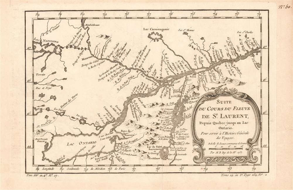
Suite Du Cours Du Fleuve De St. Laurent: Depuis Quebec jusqu'au Lac Ontario.
1780 (undated) 7.5 x 11.25 in (19.05 x 28.575 cm) 1 : 2900000
1780 (undated) 7.5 x 11.25 in (19.05 x 28.575 cm) 1 : 2900000
Description
This is a beautifully engraved 1780 Bellin map of Lake Ontario, Lake Champlain, and Lake George, and the upper course of the Saint Lawrence River, as far as Beauport and Quebec City. Montreal appears as a small island divided from the Île Jésus by the here-unnamed Rivière des Prairies. The map shows Le Trois Rivieres, marking three lakes as its sources (greatly simplifying the multitude of lakes in that region.) Lake Nipissing is correctly identified as the source of the Ottawa River. French forts are shown on Lakes Champlain and Lake George, including Fort Carillon (the precursor to Fort Ticonderoga.)
Publication History and Census
The map was initially engraved for the 1757 edition of La Harpe's Abrégé de l'histoire générale des voyages, and appeared as well in its 1780 edition. The separate map appears on the market from time to time. OCLC lists fifteen examples of this map in its various editions. La Harpe's l'histoire générale is well represented in institutions.Cartographer
Jacques-Nicolas Bellin (1703 - March 21, 1772) was one of the most important cartographers of the 18th century. With a career spanning some 50 years, Bellin is best understood as geographe de cabinet and transitional mapmaker spanning the gap between 18th and early-19th century cartographic styles. His long career as Hydrographer and Ingénieur Hydrographe at the French Dépôt des cartes et plans de la Marine resulted in hundreds of high quality nautical charts of practically everywhere in the world. A true child of the Enlightenment Era, Bellin's work focuses on function and accuracy tending in the process to be less decorative than the earlier 17th and 18th century cartographic work. Unlike many of his contemporaries, Bellin was always careful to cite his references and his scholarly corpus consists of over 1400 articles on geography prepared for Diderot's Encyclopedie. Bellin, despite his extraordinary success, may not have enjoyed his work, which is described as "long, unpleasant, and hard." In addition to numerous maps and charts published during his lifetime, many of Bellin's maps were updated (or not) and published posthumously. He was succeeded as Ingénieur Hydrographe by his student, also a prolific and influential cartographer, Rigobert Bonne. More by this mapmaker...
Source
De la Harpe, Abrégé de l'histoire générale des voyages. (Paris), 1780.
Condition
Very good. Lightly toned. Wide margins, no repairs.
References
OCLC 633087029.