This item has been sold, but you can get on the Waitlist to be notified if another example becomes available, or purchase a digital scan.
1899 Boston and Maine Railroad Map of Lake Sunapee, New Hampshire
LakeSunapee-randavery-1899$75.00

Title
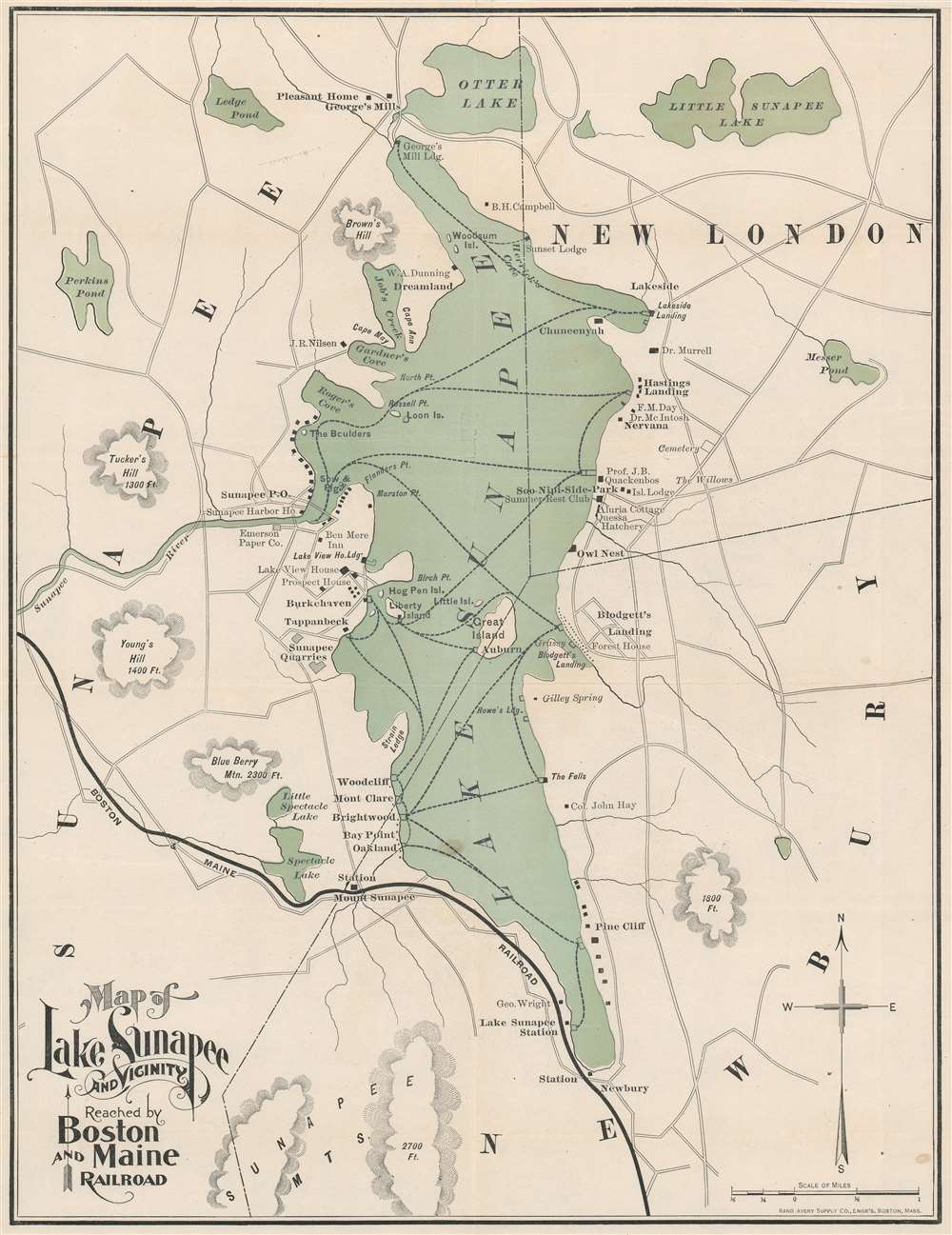
Map of Lake Sunapee and Vicinity Reached by Boston and Maine Railroad.
1899 (undated) 18.25 x 14.25 in (46.355 x 36.195 cm) 1 : 31680
1899 (undated) 18.25 x 14.25 in (46.355 x 36.195 cm) 1 : 31680
Description
This is an 1899 Rand Avery Supply Company and Boston and Maine Railroad map of Lake Sunapee, New Hampshire. Rail service to Lake Sunapee from Boston was completed in 1854, long before the advent of the automobile. This event almost immediately made the lake and its surrounding towns a vacation destination for urbanites. Lodges, homes, hotels, boat ramps, businesses, train stations, and other important tourist infrastructure quickly followed. A solid black line in the bottom left illustrates the Boston and Maine's route.
Boston and Maine Railroad
Commonly known as the 'B and M', the Boston and Maine Railroad was chartered in New Hampshire on June 27, 1835. The firm consolidated several smaller companies, including the Andover and Haverhill Railroad and later the Boston and Portland Railroad. It merged with the Maine, New Hampshire and Massachusetts Railroad in 1842, but retained the Boston and Maine operating name. In the subsequent decades it acquired or leased several other railroads, including the Boston and Lowell (1887), Northern (1884), Connecticut River (1893), Concord and Montreal (1887), and Fitchburg (1900). In 1910 it was acquired by J. P. Morgan and his New York, New Haven and Hartford Railroad. The firm initially prospered on the development of mill towns throughout New England and later capitalized on tourism from urban centers in Boston and New York. Nonetheless, the railroad went through a decline during the Great Depression and subsequently, when most of the old textile mills closed. Part of the Boston and Maine network remain in operation today under the Pan Am Railways (PAS) brand.Publication History and Census
This map was created by the Rand Avery Supply Company and published by the Passenger Department of the Boston and Maine Railroad in the second edition of Summer Excursions to the White Mountains, Mount Desert... in 1899. Two examples of the map are cataloged in OCLC and are part of the institutional collections at Harvard University and Dartmouth College.Cartographer
Rand, Avery, and Company (1851 – 1886) was a Boston based book and map printer active in the late 19th century. The company was founded in 1851 by George Curtis Rand (December 13, 1819 – December 30, 1878) and his brother-in-law Abraham Avery (November 15, 1824 - April 3, 1893). George C. Rand was a brother to William H. Rand of Rand, McNally, and Company of Chicago. George C. Rand was born in Woodstock, Vermont, to Baptist minister John Rand (1781 – 1855) and his wife. Rand began working in the printing industry from at least the 1840s, wherein he mostly produced religious tracts. He married Julia Avery in 1851 and brought his brother-in-law, Abraham Avery, into the business, renaming the firm Rand, Avery, and Company. Avery was born in Wibraham, Massachusetts and studied at Wesleyan University, which his father helped to found. Rand, Avery, and Company was based in Cornhill, Boston, and was, for a time, they were the largest printers in New England. Such works as Uncle Tom's Cabin were included in their catalog. Avery retired when Rand died in 1878, but the firm continued to publish under another generation of managers, including Rand's son, Avery L. Rand, until at least 1886. They also took on a fourth partner, Orrin F. Frye, and published as Rand, Avery, and Frye. After retiring Avery moved to Los Angeles where he died in 1893. It appears that this firm also published under the name the Rand Avery Supply Company. More by this mapmaker...
Source
Boston and Maine Railroad. Summer Excursions to the White Mountains, Mount Desert, Montreal and Quebec, Winnepesaukee, Memphremagag, Rangleley and Moosehead Lakes, and the New England Beaches. Routes, Rates, Maps, Hotel and Boarding-House List, etc., etc., Second Edition, (Boston: Passenger Department, Boston and Maine Railroad), 1899.
Condition
Very good. Backed on archival tissue. Top margin extended. Blank on verso.
References
OCLC 26842033.