
This item below is out of stock, but another example (left) is available. To view the available item, click "Details."
Details
1958 / c. 1978 Capital Offset Nautical Chart of Lake Winnipesaukee, New Hampshire
$250.00
1958 Capital Offset Nautical Chart of Lake Winnipesaukee, NH.
LakeWinnipesaukee-capitaloffset-1958$250.00


Title
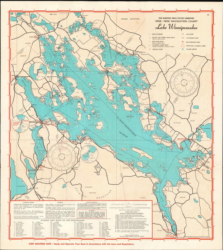
New Hampshire Public Utilities Commission 1958-1959 Navigation Chart Lake Winnipesaukee.
1958 (undated) 26.75 x 23.25 in (67.945 x 59.055 cm)
1958 (undated) 26.75 x 23.25 in (67.945 x 59.055 cm)
Description
This is a 1958 navigational chart of Lake Winnipesaukee, New Hampshire, printed on behalf of the New Hampshire Public Utilities Commission for the use of recreational boaters.
While intended for navigation, the chart also shows local roads and highways: after all, most boats finding their way onto Lake Winnipesaukee have to be brought via trailer.
A Closer Look
This attractively-presented navigational chart indicates recommended boat courses. It also marks the location of signal buoys and lights. Other useful information - the locations of fuel pumps, boat launch sites, and repair yards is marked with symbols, identified on a key. Landing zones for seaplanes are also delineated. There are three insets detailing Smith's Cove, Weirs Channel, and Sally's Gut. Depth soundings are also given. A text box at bottom reminds boaters of speed limits and other regulations.While intended for navigation, the chart also shows local roads and highways: after all, most boats finding their way onto Lake Winnipesaukee have to be brought via trailer.
Publication History and Census
This map was printed for the New Hampshire Public Utilities Commission by the Capital Offset Company in Concord, NH. It is neglected in institutional collections: we see no examples of this edition of the chart in OCLC, although Dartmouth University has an example of the 1966-1967 edition.Condition
Excellent. Original folds visible; no mends.
References
OCLC 999575662 (1966).