1885 Rand Avery Map of Lakes Winnipesaukee and Sunapee, New Hampshire
LakeWinnipesaukee-randavery-1885$600.00

Title
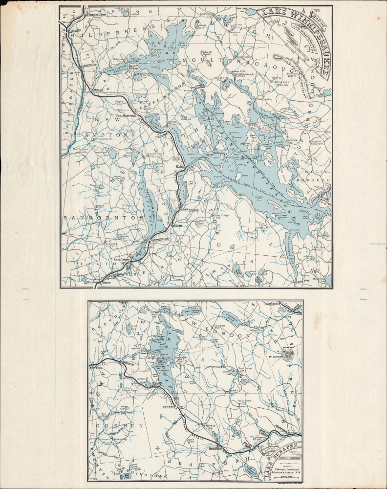
Map of Lake Winnipesaukee and Surroundings. / Map of Lake Sunapee and Surroundings.
1885 (undated) 23.5 x 13.5 in (59.69 x 34.29 cm) 1 : 115000
1885 (undated) 23.5 x 13.5 in (59.69 x 34.29 cm) 1 : 115000
Description
A scarce c. 1885 map of Lake Winnipesaukee and Lake Sunapee in New Hampshire, printed by the Rand Avery Supply Co. for the Boston and Lowell Railroad. It demonstrates the importance of the railroad as the main means by which well-heeled Bostonians of the time escaped the city in summer months to the cooler, more scenic environs of New Hampshire.
A Closer Look
Two maps are displayed on the sheet: a larger map of Lake Winnipesaukee and environs at top and a smaller map of Lake Sunapee at bottom. Both maps highlight the route of the Boston and Lowell Railroad, which was incorporated into the Boston and Maine Railroad in 1887. Both maps indicate train stations, towns, post offices, roads, waterways, mountains, steamship routes, and town boundaries.The Lady of the Lake
The steamship indicated here is the Lady of the Lake, a paddlesteamer launched in the late 1840s. By the time of this map's publication, the more modern Mount Washington, built by the Boston and Maine, was also operating on Lake Winnipesaukee, an early indication of their intention to expand operations to the Lakes Region. Although the Boston and Lowell linked up with the Boston and Maine in places, the absence of the Mount Washington reflects their somewhat competitive relationship. In 1893, the Lady of the Lake was taken out of service and stripped for parts before being intentionally sunk (at a site now popular with divers).The Boston and Lowell Railroad
The Boston and Lowell began operation in 1835, the first railroad chartered in New England for passenger transportation. It reached Nashua, New Hampshire, by 1847 and, by the late 19th century, was a preferred means of carrying seasonal tourists to New Hampshire. As seen here, the Boston and Lowell ran north-south along the west side of Lake Winnipesaukee and the southern side of Lake Sunapee. Along with its various connections, it allowed easy access by train for visitors (especially Bostonians) to Lake Winnipesaukee and Lake Sunapee, as well as to the White Mountains and Montreal beyond. The Boston and Lowell was leased by the Boston and Maine Railroad beginning in 1887, only two years after this map was published.Publication History and Census
These maps appeared in the 1885 (first) edition of Summer Saunterings: a guide to pleasant places among the mountains, lakes and valleys of New Hampshire, Vermont and Canada, published by the Boston and Lowell Railroad. However, in that work and in a subsequent edition the following year, they were published on separate pages. The colored lines in the margins suggest that this may be a proof print, used by the printer (chromist) to ensure the color plates had lined up correctly; in any event, it is an especially rare presentation of these maps.Cartographer
Rand, Avery, and Company (1851 – 1886) was a Boston based book and map printer active in the late 19th century. The company was founded in 1851 by George Curtis Rand (December 13, 1819 – December 30, 1878) and his brother-in-law Abraham Avery (November 15, 1824 - April 3, 1893). George C. Rand was a brother to William H. Rand of Rand, McNally, and Company of Chicago. George C. Rand was born in Woodstock, Vermont, to Baptist minister John Rand (1781 – 1855) and his wife. Rand began working in the printing industry from at least the 1840s, wherein he mostly produced religious tracts. He married Julia Avery in 1851 and brought his brother-in-law, Abraham Avery, into the business, renaming the firm Rand, Avery, and Company. Avery was born in Wibraham, Massachusetts and studied at Wesleyan University, which his father helped to found. Rand, Avery, and Company was based in Cornhill, Boston, and was, for a time, they were the largest printers in New England. Such works as Uncle Tom's Cabin were included in their catalog. Avery retired when Rand died in 1878, but the firm continued to publish under another generation of managers, including Rand's son, Avery L. Rand, until at least 1886. They also took on a fourth partner, Orrin F. Frye, and published as Rand, Avery, and Frye. After retiring Avery moved to Los Angeles where he died in 1893. It appears that this firm also published under the name the Rand Avery Supply Company. More by this mapmaker...
Condition
Good. Light soiling, light foxing. Some wear along edge, including small area of loss at top-left corner.