
1901 Rand Avery Map of Lake Winnipesaukee and Environs, New Hampshire

This item has been sold.
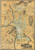
Map of Lake Winnipesaukee and Vicinity Reached by Boston and Maine R.R. and Steamer Mt. Washington.
Integration of Rail and Steamer Service.
- Digital Map Information
- Suitable for large format printing
- Full resolution TIFF file
- ICC color profile embedded
- Delivered instantly via download link
Integration of Rail and Steamer Service.
This is a 1901 Rand Avery Supply Company map of Lake Winnipesaukee, New Hampshire, and environs, produced for the Boston and Maine Railroad. It reflects the seamless integration of rail and steamer service that the Boston and Maine had perfected by this point, bringing passengers from Boston, New York, and other coastal cities directly to their hotel and resort destinations around the lake.A Closer Look
Lake Winnipesaukee is the largest lake in New Hampshire and a popular resort area. The map covers the titular lake and its immediate surroundings, including Squam Lake, several smaller lakes and ponds, and towns, such as they were, including Centre (Center) Harbor, Wolfeborough (Wolfeboro), Alton Bay, and Lakeport/Laconia. Thick black lines trace the Boston and Maine Railroad's lines throughout. Dashed lines follow the course of the Mount Washington, a steamer operated by the Boston and Maine from 1872 to carry passengers, goods, and mail around Lake Winnipesaukee (a passenger service still operates under this name, albeit using a more recent ship equipped with diesel engines).Lake Winnipesaukee's Emergence as a Resort Destination
In the late 19th century, Lake Winnipesaukee became a premier American vacation destination. This development was made possible by the rapid expansion of the region's railroad network under the auspices of the Boston and Maine Railroad, which aggressively expanded and consolidated its lines. By establishing direct routes and integrating vital branches around the lake, the Boston and Maine successfully linked the pristine waters of the Lakes Region to major urban hubs like Boston, New York, and Hartford. This unprecedented connectivity made the rugged beauty of northern New England easily accessible to a surging urban population eager to escape the stifling heat and industrial congestion of Gilded Age cities.The true hallmark of Winnipesaukee's late-19th-century tourism layout lay in the seamless integration of rail and water travel engineered by the railroad companies. Upon arriving at lakeside terminals like Alton Bay or Weirs Beach (Weirs Landing here), passengers stepped directly from trains onto grand, railroad-owned steamships, most famously the Mount Washington. These majestic vessels acted as floating extensions of the rail lines, ferrying vacationers, mail, and baggage to opulent grand hotels, rustic summer cottages, and bustling religious camp meetings scattered across the lake's islands and shorelines.
Boston and Maine Railroad
Commonly known as the 'B and M', the Boston and Maine Railroad was chartered in New Hampshire on June 27, 1835. The firm consolidated several smaller companies, including the Andover and Haverhill Railroad and, later, the Boston and Portland Railroad. It merged with the Maine, New Hampshire and Massachusetts Railroad in 1842, but retained the Boston and Maine operating name. In the subsequent decades, it acquired or leased several other railroads, including the Boston and Lowell (1887), Northern (1884), Connecticut River (1893), Concord and Montreal (1887), and Fitchburg (1900). In 1910, it was acquired by J. P. Morgan and his New York, New Haven and Hartford Railroad. The firm initially prospered on the development of mill towns throughout New England and later capitalized on tourism from urban centers in Boston and New York. Nonetheless, the railroad went through a decline during the Great Depression and subsequently, when most of the old textile mills closed. Part of the Boston and Maine network remains in operation today under the Pan Am Railways (PAS) brand.Publication History and Census
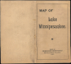
This map was created by the Rand Avery Supply Company for the Boston and Maine Railroad. Although a similar map appeared earlier in the promotional booklet Boston and Maine Railroad. Summer Excursions to the White Mountains... (see our earlier listing LakeWinnipesaukee-randavery-1899), this example is separately issued with a binder dated 1901. Since the map itself is not dated, a census is difficult to establish, but the OCLC notes three examples with titles matching the present map, held by the University of Wisconsin-Milwaukee, Plymouth State University, and Dartmouth University (digitized and seemingly matching the present map, though a tear has removed the publication information at the bottom-right).Cartographer
Rand, Avery, and Company (1851 – 1886) was a Boston based book and map printer active in the late 19th century. The company was founded in 1851 by George Curtis Rand (December 13, 1819 – December 30, 1878) and his brother-in-law Abraham Avery (November 15, 1824 - April 3, 1893). George C. Rand was a brother to William H. Rand of Rand, McNally, and Company of Chicago. George C. Rand was born in Woodstock, Vermont, to Baptist minister John Rand (1781 – 1855) and his wife. Rand began working in the printing industry from at least the 1840s, wherein he mostly produced religious tracts. He married Julia Avery in 1851 and brought his brother-in-law, Abraham Avery, into the business, renaming the firm Rand, Avery, and Company. Avery was born in Wibraham, Massachusetts and studied at Wesleyan University, which his father helped to found. Rand, Avery, and Company was based in Cornhill, Boston, and was, for a time, they were the largest printers in New England. Such works as Uncle Tom's Cabin were included in their catalog. Avery retired when Rand died in 1878, but the firm continued to publish under another generation of managers, including Rand's son, Avery L. Rand, until at least 1886. They also took on a fourth partner, Orrin F. Frye, and published as Rand, Avery, and Frye. After retiring Avery moved to Los Angeles where he died in 1893. It appears that this firm also published under the name the Rand Avery Supply Company. Further Details...
Condition
Fair. Backed on archival tissue for stability. Slight loss where previously attached to binder (see Squam Lake). Old verso repair to closed tear extending 1.5 inches into the printed area from the left margin. Other small areas of loss at fold intersections.
References
OCLC 25359401 (multiple editions co-mingled).