This item has been sold, but you can get on the Waitlist to be notified if another example becomes available, or purchase a digital scan.
1927 Burwell Map of Lake Winnipesaukee, New Hampshire
LakeWinnipissiogee-burwell-1927$187.50

Title
Lake Winnipissiogee N.H.
1927 (dated) 17.5 x 22.5 in (44.45 x 57.15 cm) 1 : 50688
1927 (dated) 17.5 x 22.5 in (44.45 x 57.15 cm) 1 : 50688
Description
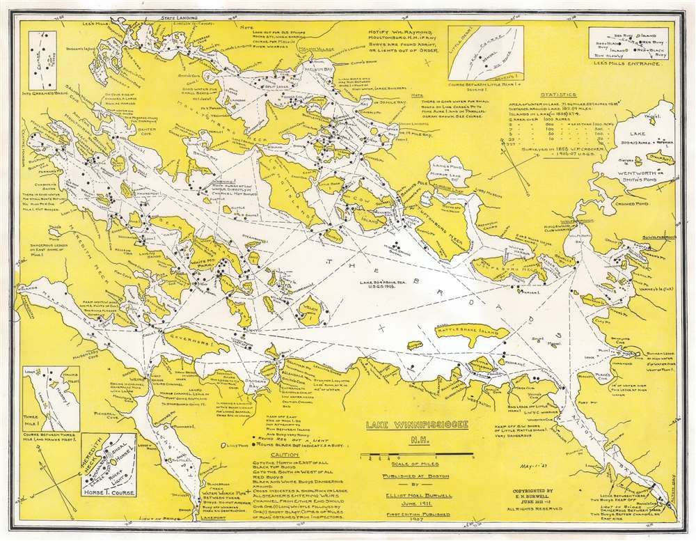
This is a 1927 Elliot Noël Burwell map of Lake Winnipesaukee, New Hampshire. Burwell marks islands, rocks, shoals, coves, points, and other landmarks and navigation hazards throughout the lake. Black dots mark buoys. Dashed lines illustrate good channels for ferries and private vessels. Information about the lake, including unmarked channels, good places to use small boats, and advice about dangerous spots appear around the lake's banks. Five small insets situated near the border detail difficult courses in certain areas of the lake.
Publication History and Census
This map was originally created and published by Elliot Noël Burwell in 1911. The present example, which we have tentatively dated to 1927 because of the notation to the right of the title, does not match any other cataloged examples, making this the only known example of this edition. Several notations present on this edition appear on none of the other editions. There are at least three other editions of this map apart from the present example. The first edition, published in 1907, bears a much different title with Lake Winnipesaukee spelled conventionally. We have encountered at least one later edition, published by Burwell in 1938 (part of the collection at Dartmouth College), that much more closely resembles the 1907 edition. This is the only known example of the 1927 edition.Condition
Very good.
References
New Hampshire Historical Society 66042. OCLC 57273414.