This item has been sold, but you can get on the Waitlist to be notified if another example becomes available, or purchase a digital scan.
1930 Auto Club of Southern California Strip Map, Sequoia and Inyo National Forest
LALonePineRoad-autoclubsocal-1935$100.00


Title
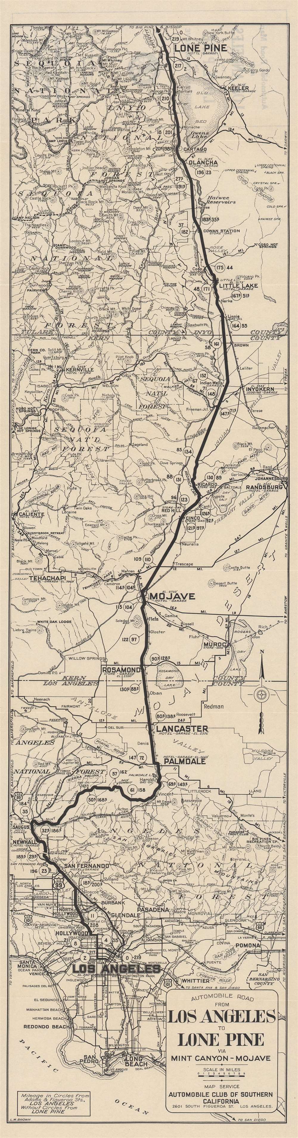
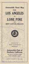
Automobile road from Los Angeles to Lone Pine via Mint Canyon-Mojave.
1935 (undated) 35.75 x 9.25 in (90.805 x 23.495 cm) 1 : 400000
1935 (undated) 35.75 x 9.25 in (90.805 x 23.495 cm) 1 : 400000
Description
This is a c. 1935 'strip map' of the automobile route from Los Angeles to Lone Pine, a town in the Owens Valley, tucked between the Sierra Nevada, White, and Inyo Mountains. The map reflects both the growing automobile infrastructure in rural California and increased interest in California's natural beauty.
Coming out of L.A., the route illustrated here utilized U.S. Route 99, which roughly followed the Native American Siskiyou Trail that was widened with increasing use by mule trains and horses in the 19th century before being turned into roadway in the early 20th century. The U.S. Route was decommissioned with the opening of Interstate 5, but large portions of it remain in California as State Highway 99.
After San Fernando, the route branched off from U.S.-99 and followed the El Camino Sierra, later called the 'Sierra Highway' (today mostly S.R. 14 and U.S. Route 395), portions of which ran parallel to the Southern Pacific rail lines. The previously little-known route was promoted as a scenic tourist highway in the early 20th century. However, it was hardly an easy jaunt from Los Angeles; the portion from Mojave to Owens Valley, the top half of this map, was only paved in 1931.
Near the top of the map, the route passes Sequoia and Inyo National Forests and Mt. Whitney, the highest peak in the contiguous 48 states. Inyo National Forest was created 1907, and Sequoia two years later in 1909. Along with a general movement towards conservation in the American West, these forests reflected a particular interest in protecting Giant Sequoias, including several of the largest trees on Earth. Although not as badly destroyed as the coast redwoods (Sequoia sempervirens) (some 95% of which were logged in the 19th and early 20th century), the Giant Sequoias (Sequoiadendron giganteum) were also logged on a large scale and some one-third were lost before conservation efforts in the 1860s. The development of hiking trails in the early 20th century, such as the John Muir Trail and High Sierra Trail, also increased both conservation efforts and tourism.
A Closer Look
This map highlights the evolving road infrastructure in Los Angeles County, and to a lesser extent in rural Kern and Inyo counties. The numbers in circles along the route indicate distances from downtown L.A., while numbers not encircled represent the same in the opposite direction from Lone Pine. The route bolded here travelled through a variety of terrains and climates, from the L.A. Basin and San Fernando Valley, slipping through the San Gabriel Mountains and into the Mojave Desert, and then along the eastern edge of the Sierra Nevada. Lone Pine was and remains a great location for nature tourism given its proximity to Mount Whitney and Sequoia, Inyo, Death Valley, and Kings Canyon (at that time General Grant) National Forests and Parks.Coming out of L.A., the route illustrated here utilized U.S. Route 99, which roughly followed the Native American Siskiyou Trail that was widened with increasing use by mule trains and horses in the 19th century before being turned into roadway in the early 20th century. The U.S. Route was decommissioned with the opening of Interstate 5, but large portions of it remain in California as State Highway 99.
After San Fernando, the route branched off from U.S.-99 and followed the El Camino Sierra, later called the 'Sierra Highway' (today mostly S.R. 14 and U.S. Route 395), portions of which ran parallel to the Southern Pacific rail lines. The previously little-known route was promoted as a scenic tourist highway in the early 20th century. However, it was hardly an easy jaunt from Los Angeles; the portion from Mojave to Owens Valley, the top half of this map, was only paved in 1931.
Near the top of the map, the route passes Sequoia and Inyo National Forests and Mt. Whitney, the highest peak in the contiguous 48 states. Inyo National Forest was created 1907, and Sequoia two years later in 1909. Along with a general movement towards conservation in the American West, these forests reflected a particular interest in protecting Giant Sequoias, including several of the largest trees on Earth. Although not as badly destroyed as the coast redwoods (Sequoia sempervirens) (some 95% of which were logged in the 19th and early 20th century), the Giant Sequoias (Sequoiadendron giganteum) were also logged on a large scale and some one-third were lost before conservation efforts in the 1860s. The development of hiking trails in the early 20th century, such as the John Muir Trail and High Sierra Trail, also increased both conservation efforts and tourism.
Publication History and Census
This map was made by L.M. Brown of the Automobile Club of Southern California c. 1935. The Automobile Club produced dozens if not hundreds of these distinctive 'strip maps' or sectional road maps in the 1920s – 1940s, but each was seemingly printed in a small run, and they are difficult to find today. This map is held by five universities in the United States and is very scarce to the market.Cartographer
The Automobile Club of Southern California (1900 - Present) is an auto club based in Los Angeles, California and an affiliate of the American Automobile Association (AAA). Founded in 1900, it was one of the first auto clubs in the United States and was dedicated to proposing traffic laws, improving road conditions, and the overall improvement of driving conditions. The Auto Club began producing its own maps in 1910, when it sent out its own team of cartographers to survey the state's roads. Its main office at the corner of Figueroa Street and Adams Boulevard was completed in 1923. Numbering nearly 8 million members in its home territory alone, today it is the largest single member of the AAA federation More by this mapmaker...
Condition
Very good.
References
OCLC 24994663.