This item has been sold, but you can get on the Waitlist to be notified if another example becomes available, or purchase a digital scan.
1855 Bellin 'French and Indian War' Map of Louisiana and North America
LaLouisiane-bellin-1755$1,125.00

Title
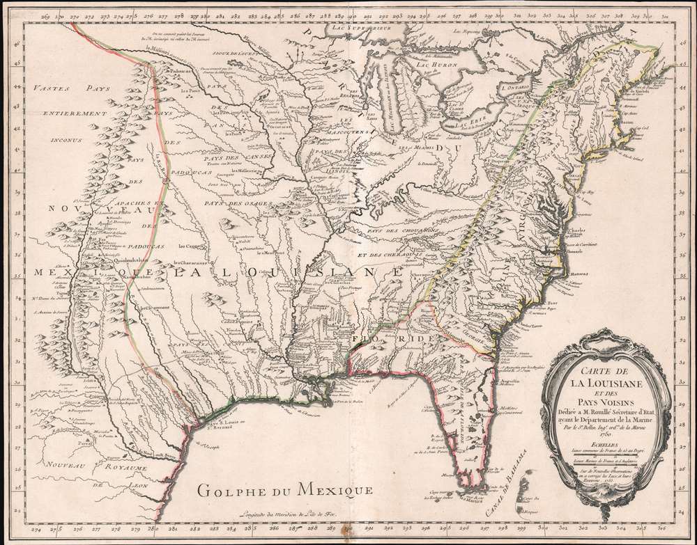
Carte de La Louisiane et des Pays Voisins.
1755 (dated) 19.25 x 24.5 in (48.895 x 62.23 cm) 1 : 5800000
1755 (dated) 19.25 x 24.5 in (48.895 x 62.23 cm) 1 : 5800000
Description
An unusual and scarce 1755 map of North America by Jacques-Nicolas Bellin issued at the outbreak of the French and Indian War (1754 - 1763). Centered on the vast Mississippi Valley, the map covers from the Rio Grande to the Atlantic Seaboard and from Lake Superior to the Florida Keys. While first issued in 1750, the present map has been updated considerably to represent French, English, and Spanish claims at the outbreak of the French and Indian War. Most of the most important battle sites are forts are noted, including Fort Duquesne, Fort Necessity, Fr. Le Boeuf, Fort Presqu'Isle, and Fort St. Frederic, among others.
Territorial Boundaries
The map presents the much of the modern United States as the French understood it at the outbreak of the war. Spanish territory is red, English territory is yellow, and French territory is green. The British are here restricted to the coastal lands east of the Appalachian Mountains, and bounded on the south by the Altamaha River, which forms the boundary with Spanish Florida. French Territorial claims are expansive, encompassing roughly 2/3rds of the land and controlling the most valuable waterways, including the Great Lakes, the Ohio, and the Mississippi. Forts, mission settlements, mines, and trading posts dot the Mississippi Valley, but in truth, most of these were, by this time, only loosely manned or altogether abandoned - hardly an argument for effective occupation.French and Indian War
The French and Indian War (1754 - 1763) was the North American extension for the worldwide Seven Years' War (1756 - 1763). It is generally considered distinct from the global conflict due in part to its isolation, and in part to the participation of Native American peoples. The war fought between the British Colonies in North American and New France; each side being supported by Native American allies. Conflict erupted over conflicting claims to the Ohio River, Allegheny, and Monongahela River valleys, and the Great Lakes. The French believed that their territory extended eastward to the Appalachian Mountains, including all five of the Great Lakes, while the British crown had long made a practice of offering coast-to-coat grants. The French and British were in very different positions at the outbreak of the war. The British controlled the coast and North America largest cities, with a total population over 2,000,000. The French on the other hand, controlled Quebec, the Great Lakes, and the Mississippi Valley. Nonetheless, their hegemony in the region was tenuous at best. With less than 60,000 settlers in New France, the French instead relied on close ties with Native American nations. Formal warfare commenced on July 4, 1755, when George Washington's troops were defeated at Fort Necessity (F. de Necessité détruit), and five days later General Braddock's troops were repelled at the battle of the Wilderness below Fort Le Quesne (Fort Duquesne). Although they initially won several important victories, the French were ultimately overwhelmed by better supplied more numerous British troops and, being occupied in their European war against Prussia, were unwilling to commit further reinforcements. Ultimately, the French surrendered to the British. In the subsequent 1863 Treaty of Paris, France surrendered all of its North American possessions to the Great Britain - forever transforming this history of North America.Sources
This map features a wealth of cartographic information drawn in part from the Guilaume de L'Isle map of 1718, but has been expanded considerably with new information from the the Chaussegros de Lery manuscripts and Pierre-Francois-Xavier de Charlevoix s Histoire et description generale de la Nouvelle France. Of note is the curious mountain range running through Michigan.Up to Date Information
The inclusion of Fort Necessity is significant, as it suggests this map was issued just months after the construction of the fort and George Washington's disastrous defeat there. It underscores how quickly information moved - even through the outback of the New World and active war. For this map to have been made, news of the events, as well as cartographic reconnaissance, would have had to move rapidly from Fort Duquesne, down the Ohio River, then down the full length of the Mississippi, then across the Atlantic to Paris. There Bellin would have had to study the work, reconcile it with his older maps, update and re-engrave them accordingly, and then get the map to the presses for distribution. The whole is a remarkable accomplishment, but may explain somewhat this maps scarcity, as in a short time, much of the data he would be irreverent.The Dedicatee: Antoine-Louis Rouillé
The map is dedicated to Antoine-Louis Rouillé, comte de Jouy (1689 - 1761). Rouillé replaced Jean-Frédéric Phélypeaux, 1st Count of Maurepas (1701 - 1781), Bellin's former patron, as Secretary of State for the Navy (Ministère de la Marine) on July 24, 1754, just in time for the French and Indian War. Bellin, who worked under the Navy Department, would have been highly motivated to engender Rouillé patronage and good well, making the dedication unsurprising.Publication History and Census
This map was separately published in Paris, France by Jacques-Nicolas Bellin. It is dedicated to M. Rouillé. It represents the second state of the map, 1755, issued during the French and Indian War. Examples are extremely scarce. We have identified only three examples, including this map, in the last 20 years of market history. The map is further not identified in Cumming, Karpinski, Ehrenberg, or Phillips. The OCLC notes examples in 8 institutions, but upon closer inspection many of these appear to be digital resources and do not represent any actual holdings.CartographerS
Jacques-Nicolas Bellin (1703 - March 21, 1772) was one of the most important cartographers of the 18th century. With a career spanning some 50 years, Bellin is best understood as geographe de cabinet and transitional mapmaker spanning the gap between 18th and early-19th century cartographic styles. His long career as Hydrographer and Ingénieur Hydrographe at the French Dépôt des cartes et plans de la Marine resulted in hundreds of high quality nautical charts of practically everywhere in the world. A true child of the Enlightenment Era, Bellin's work focuses on function and accuracy tending in the process to be less decorative than the earlier 17th and 18th century cartographic work. Unlike many of his contemporaries, Bellin was always careful to cite his references and his scholarly corpus consists of over 1400 articles on geography prepared for Diderot's Encyclopedie. Bellin, despite his extraordinary success, may not have enjoyed his work, which is described as "long, unpleasant, and hard." In addition to numerous maps and charts published during his lifetime, many of Bellin's maps were updated (or not) and published posthumously. He was succeeded as Ingénieur Hydrographe by his student, also a prolific and influential cartographer, Rigobert Bonne. More by this mapmaker...
The De L'Isle family (fl. c. 1700 - c. 1760) (also written Delisle) were, in composite, a mapmaking tour de force who redefined early 18th century European cartography. Claude De L'Isle (1644 -1720), the family patriarch, was Paris based a historian and geographer under Nicholas Sanson. De L'Isle and his sons were proponents of the school of "positive geography" and were definitive figures, defining the heights of the Golden Age of French Cartography. Of his twelve sons, four, Guillaume (1675 - 1726), Simon Claude (1675 - 1726), Joseph Nicholas (1688 - 1768) and Louis (1720 - 1745), made a significant contributions to cartography. Without a doubt Guillaume was the most remarkable member of the family. It is said that Guillaume's skill as a cartographer was so prodigious that he drew his first map at just nine years of age. He was tutored by J. D. Cassini in astronomy, science, mathematics and cartography. By applying these diverse disciplines to the vast stores of information provided by 18th century navigators, Guillaume created the technique that came to be known as "scientific cartography", essentially an extension of Sanson's "positive geography". This revolutionary approach transformed the field of cartography and created a more accurate picture of the world. Among Guillaume's many firsts are the first naming of Texas, the first correct map of the Mississippi, the final rejection of the insular California fallacy, and the first identification of the correct longitudes of America. Stylistically De L'Isle also initiated important changes to the medium, eschewing the flamboyant Dutch style of the previous century in favor of a highly detailed yet still decorative approach that yielded map both beautiful and informative. Guillaume was elected to the French Academie Royale des Sciences at 27. Later, in 1718, he was also appointed "Premier Geographe du Roi", an office created especially for him. De L'Isle personally financed the publication of most of his maps, hoping to make heavy royalties on their sales. Unfortunately he met an untimely death in 1728, leaving considerable debt and an impoverished child and widow. De L'Isle's publishing firm was taken over by his assistant, Phillipe Buache who became, posthumously, his son in law. The other De L'Isle brothers, Joseph Nicholas and Louis De L'Isle, were employed in the Service of Peter the Great of Russia as astronomers and surveyors. They are responsible for cataloguing and compiling the data obtained from Russian expeditions in the Pacific and along the northwest coast of America, including the seminal explorations of Vitus Bering and Aleksei Chirikov. The De L'Isles, like their rivals the Vaugondys , must be considered speculative geographers. Speculative geography was a genre of mapmaking that evolved in Europe, particularly Paris, in the middle to late 18th century. Cartographers in this genre would fill in unknown areas on their maps with speculations based upon their vast knowledge of cartography, personal geographical theories, and often dubious primary source material gathered by explorers and navigators. This approach, which attempted to use the known to validate the unknown, naturally engendered many rivalries. The era of speculatively cartography effectively ended with the late 18th century explorations of Captain Cook, Jean Francois de Galaup de La Perouse, and George Vancouver. Learn More...
Condition
Good. Slight centerfold wear. Minor discoloration bottom margin. Some old toning on verso.
References
OCLC 5401780. Lowery, W., The Lowery Collection, 406.