
1851 Map of Lancaster County, Pennsylvania

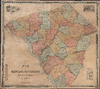
Map of Lancaster County, Pennsylvania.
- Digital Map Information
- Suitable for large format printing
- Full resolution TIFF file
- ICC color profile embedded
- Delivered instantly via download link
A Closer Look
The map encompasses the county from the northern townships adjoining Lebanon and Berks Counties to Mason and Dixon's Line at the Maryland boundary. The Susquehanna defines its western edge, while the Conestoga, Pequea, and Octoraro waterways organize much of the interior. Pink, yellow, and blue-green washes distinguish townships and boroughs; closely worked hachures describe the northern ridges, Welsh Mountain, and the broken terrain along the lower Susquehanna. Lancaster's street grid contrasts with the smaller settlements scattered through the countryside. The detail is especially useful for reconstructing relationships among farms, local services, and manufacturing. Individual residences appear beside their occupants' names, interspersed with schools, taverns, mills, furnaces, ore banks, and churches. Mennonite meetinghouses are explicitly identified in several townships, while the Moravian Society's estate is marked at Lititz. These labels document religious institutions within the working landscape without classifying the religious affiliations of individual households.Railways cross the county through Lancaster and toward Columbia and Harrisburg, supplementing the dense road network. Along the Susquehanna, the map identifies canals, ferries, and the Columbia Bridge, with its canal tow bridge separately labeled. Ore banks near Marietta and ironworks at Safe Harbor further complicate any impression of an exclusively agricultural county. Read together, these features suggest the map's practical value for locating people, businesses, and routes within an increasingly interconnected local economy.
An alphabetical directory at lower left pairs post offices with their townships. At lower right, an 1850 statistical table compares population, dwellings, families, acreage, assessed property values, and estimated actual wealth. It reports a combined city and county population of 99,760, including 12,380 in Lancaster city. These tabulations turn the wall map into a compact geographical and economic reference.
Steam Mills and a New County Prison
At upper left, four architectural views enclosed by looping flourishes illustrate the Conestoga Steam Mills. Smoking chimneys emphasize the power source, an important distinction in a county where numerous smaller mills occupied streamside sites. Lancaster's municipal history identifies the complex as the county's first steam-powered cotton mill and notes that Mill No. 1 was the city's largest building when operations began in 1847. The vignette thus celebrates a substantial recent investment in factory production.The upper-right vignette presents the new county prison as a castellated public monument. Designed by John Haviland, it embodied the Pennsylvania separate system, which sought reform by isolating prisoners from one another. Its radial arrangement allowed supervision from a central position, although the map's exterior view emphasizes the monumental entrance rather than the internal plan. The first prisoners arrived on September 12, 1851, making this an illustration of the institution in its opening year.
Publication History and Census
The map is dated 1851 in the title. The imprint beneath the prison view identifies P. S. Duval's Steam Lithographic Press in Philadelphia; no compiler or publisher is named. The institutional record identifies examples at the Pennsylvania State Archives, Family History Library in Salt Lake City, and the Library of Congress. No market history.Cartographer
Peter Stephen Duval (1804 - February 8, 1886) was a prominent French-American Philadelphia lithographer. He immigrated to Philadelphia from France in 1831 to take a job as a lithographer at the Philadelphia firm of Cephas Childs (Childs and Inman), one of Philadelphia's first commercial lithographing firms. In 1834, Childs retired, and Duval took over the business with the artist George Lehman, operating as Lehman and Duval. Duval bought out Lehman in 1837 and, from that point forward, operated as P. S. Duval's Lithographic Establishment, or just Duval's Establishment. In the 1840s, he became one of the first firms to introduce steam-powered lithographic presses. In 1841, he became a naturalized U.S. citizen. At one point, he had over 30 presses and employed 70 artists and was one of Philadelphia's largest lithographic printers. Over the course of the next 30 years, Duval would have several business partners, including the Swiss-American engravers Charles and Frederick Bourquin (1808 - 1897). In 1857, his son Steven C. Duval joined the business. Peter Duval retired in 1869 but continued to be involved in his company until his death from an enlarged heart in 1886. Duval was a member of the local branches of the Freemasons and the Order of Odd Fellows in addition to being president of the Philadelphia Lithographers' Association. Further Details...
Condition
Very good. Devarnished, deacidified, and laid down on pH neutral linen.
References
OCLC 828073999. Library of Congress, G3823.L3 1851 .M3. Pennsylvania State Archives, MG-11 Map Collection, map 42. Docktor, John W., 'Putting Lancaster on the Map: A Current Exhibit', The Portolan, No. 54, Fall 2002, p. 6.