
1788 Vicenzo Formaleoni argument for a Venetian Discovery of America

Essai sur la Marine Ancienne des Venetiens.
Supporting a pre-Columbian, Venetian discovery of America.
Supporting a pre-Columbian, Venetian discovery of America.
This scarce book is the 1788 French edition of Vincenzio Antonio Formaleoni's (1752 - 1797) Saggio sulla nautica antica de' Veneziani (Essay on the ancient navigation of the Venetians). Formaleoni presented the manuscript maps of the 15th-century Venetian Andrea Bianco as support for his argument that the Venetians had discovered America long before the Genoan Columbus. While this interpretation of Bianco's work is no longer supported, the copperplate charts in Formaleoni's text are among the earliest glimpses of Bianco's 15th-century manuscripts available outside Venice's Biblioteca Marciana, where they were preserved in the 18th century. They are now the only way the collector can access these charts.A Closer Look
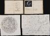
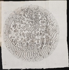
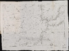
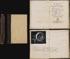
This 168-page octavo, rebound in paper-covered boards probably in the 20th century, bears the gold-embossed title 'Before Columbus - Formaleoni - 1788' on the spine, at variance with the book's title, Essai sur la Marine Ancienne des Venetiens. Four plates are bound at the end of the book, three of them folding: two comprise diagrams representing 15th-century Venetian navigational methodology, while two are copperplate renditions of c. 1436 manuscript maps drawn by Andrea Bianco. One of these is a mappamundi. The other is a chart of the Atlantic adjacent to Spain, Africa, and the Strait of Gibraltar, including the Canary Islands and the Madeiras. Both include an array of phantom islands which intrigued Formaleoni.The Mappamundi
This circular map presents the known world of the 15th century. Like other medieval mappamundae, it is oriented to the east, with north to the left, and is essentially a visually embellished map on the T-O model. At the bottom, Europe's features are recognizable, most notably the Iberian Peninsula, Italy, the Mediterranean Sea, and the Black Sea. The lands of the Bible - the holy land, Mesopotamia, Babylon, and Jerusalem - appear at the center of the map. Remarkably, Africa - though distorted far to the east - appears to be circumnavigable, which Europeans would not confirm until more than thirty years after the manuscript original of the map was executed. This contradicted Ptolemy, but was an idea supported by other geographers and historians in antiquity, such as Strabo and Herodotus. Admittedly, the extreme south coast of Africa is menaced by two dragons, posing a challenge. The eastern extremes of the map reflect Biblical certainties of the era: the land of Gog and Magog is illustrated, as well as the Garden of Eden.At the bottom of the map is an array of islands - some recognizable as the Canary Islands, some derived from the 'Fortunate Isles' of Ptolemy and the ancients, and two large, unnamed islands directly west of the Iberian Peninsula (which also appear in the following chart).
The Portolan
Accompanying the mappamundi is this chart of the Atlantic Ocean west of the Strait of Gibraltar, and the western Mediterranean Sea. As with the mappamundi, it was sourced from the 1436 manuscript atlas attributed to Bianco. It includes the southern and western coasts of the Iberian Peninsula, and the northwestern coast of Africa from Cape Spartel to Cape Bojador. The Canary Islands and Madeira Archipelago are mapped. Other islands - possibly signifying the Açores, but likely fantastic - appear north of the Madeiras. These include the phantom island of Brazil. At the extreme west of the chart are two large islands: Antillia and the island 'Ya. De la man Satanaxio' (roughly, Island of the hand of Satan). The island appears more frequently as 'Island of Demons'.Antillia and the Cities of Gold
These islands were not unique to the Bianco charts, but appeared on a handful of surviving Italian manuscript charts produced throughout the 15th century. Their first surviving appearance is on a Portolan chart by Zuane Pizzigano, dated to 1424. The island was a legendary place, associated with the 8th-century Moorish invasion of Porto: the tale has it that when the city fell, its seven bishops fled with their treasures to sea. Miraculously, they found refuge in an island paradise. In that paradise of Antillia, each bishop founded a city. When explorers failed to discover Antillia in the Atlantic, these fabled seven cities of gold were assumed to exist further west: in Mexico, perhaps, or amongst the Zuni Pueblos of the North American southwest.Island of Demons
What Bianco termed Ya de la man Santanaxio appears first on the 1424 Zuane Pizzigano Portolan, accompanying Antillia. On the few surviving 15th-century charts that show Antillia, the Island of Demons almost always appears with it. No clearly established legend explains the island. In 1889, Nordenskiöld was the first scholar to propose that these 'devils' referred to the Skraelings, the indigenous people of Greenland and Vinland reported in the Norse Sagas. An Isla de Demoni later appeared on the 1508 Ruysch map and the 1556 Ramusio Nuova Francia.Venetian Propaganda
Formaleoni was not specifically interested in Antillia's cities of gold or the Isle of Demons; he was fixated on the certainty that Venetian sailors had reached the New World long before Columbus. He knew these large islands did not actually exist as portrayed on these charts. However, their presence on an otherwise excellent and accurate chart suggested to him that they derived from a partial, collective knowledge preserved by Venetian chartmakers of great lands across the ocean.Formaleoni was not alone in his conviction that his countrymen had stolen a march on the hated Genoese in the discovery of America. Venetian resentment over Columbus' coup, and its exploitation by the Spanish and the Portuguese, would likely have bloomed as soon as the global trade of those other empires began to eclipse Venice's control of Mediterranean trade. This resentment took form in 1558 with Venetian patrician Nicolò Zeno the younger's fabricated account of the 1380s voyage of his forebears, Nicolò and Antonio Zeno. Zeno the Younger presented letters, supposedly from Antonio Zeno to his Venetian relatives, claiming that the 14th-century voyages had crossed the Atlantic and discovered, among other places, the phantom island of Frisland, and the coastlines of Estotiland: the 16th-century Zeno identified the latter as Labrador, thus proposing a Venetian discovery of America a century before Columbus. Zeno's account was accompanied by a map; Zeno claimed that both the original Zeno letters and map had, sadly, been destroyed and were no longer available for scrutiny.
The research which would demolish the bona fides of the Zeno map and narrative would not occur until the late 19th century: so while scholars of Formaleoni's era conceded that Zeno's map was wrong in respect to its phantom islands, the overarching story of the Zeno brothers was accepted, and worthy of substantiation. Formaleoni therefore combed Venice's libraries for evidence that the brothers Zeno had actually made their journey, or that Venetian mariners had the mathematical skill to determine the accurate latitudes reflected in the Zeno map. He of course failed to find the original Zeno manuscript map, but in the Biblioteca Marciana he did find Andrea Bianco's 1436 atlas. This contained many geometrical models, an array of charts of the Mediterranean, a Ptolemaic oikoumene and a mappamundi. These were superior in execution to the only ancient maps Formaleoni knew; although they showed none of the Zeno geography, he used the prominent presentation of Antillia and the Isle of Demons as evidence of 15th-century Venetian knowledge of the New World.
This work strikes close to the mark of the 1558 Zeno narrative in both purpose and argument. Formaleoni was a contentious figure in the Venetian publishing world, often at odds with the city's printing guilds and frequently running afoul of better-connected, more powerful men. His later history would be marked by opportunism, as he played multiple sides in the politics of the French Revolution to strengthen (or recover) his position in Venice. The spur to his efforts here - the Patrician Zeno's 1558 publication of his forebears' spurious voyage and map - had been a largely successful effort to aggrandize both the achievements of the Zeno family specifically, and the Venetian people in general, in order to strengthen his political position in the city. Centuries later, it cannot have escaped Formaleoni that a work similarly praising the notional achievements of Venice could benefit him in his own business and political struggles.
Publication History and Census
This volume bears the bookplate of noted voracious collector Otto Orren Fisher (March 24, 1881 - September 15, 1961). It was among the items sold at auction from his collection in December 2021. This French edition of Formaleoni's 1783 'Saggio sulla nautica antica de' Veneziani' was published in 1788, and like the first Italian edition, was printed by Formaleoni's own shop. There were no further editions. We see 35 listings of the Italian edition in OCLC and only 30 of the French edition. The book is rare on the market.Cartographers
Vincenzo Antonio Formaleoni (November 18, 1752 - January 8, 1797) was an Italian cartographer, geographer, surveyor, and printer-publisher active principally in Venice during the late 18th century. Born at Fiorenzuola d'Arda, near Piacenza, he received minor ecclesiastical orders before undertaking travels that, according to his own accounts, brought him to Egypt, Constantinople, and the Black Sea. By 1775 he was working as a proofreader for the Venetian publisher Antonio Zatta (1722 - 1804), while developing his geographical and cartographic interests. His early work included a 1776 topographical map of the Dogado, Venice's metropolitan territory, and historical-topographical descriptions of the Dogado and Bergamasco published in 1777. He also collaborated with Giovanni Antonio Rizzi Zannoni (1736 - 1814) on the first sheet of the Gran carta del Padovano and supplied geographical observations concerning Africa for Zatta's Atlante novissimo. In 1778 he qualified as a public land surveyor. Having returned to lay status, he married Matilde Foresti in 1777; they had three children. Formaleoni subsequently established an independent publishing business, although guild restrictions, commercial rivalries, and censorship repeatedly obstructed his projects. His geographical publications included an extensively supplemented Italian translation of La Harpe's Compendio della storia generale de' viaggi and the Topografia veneta (1787), describing the Venetian state and its overseas possessions. His historical interests centered on Venetian origins, navigation, and commerce, notably in the Saggio sulla nautica antica de' Veneziani and Storia filosofica e politica della navigazione, del commercio e delle colonie degli antichi nel Mar Nero (1788 - 1789). Banished from Venice in 1792, he went to revolutionary France and supplied intelligence to the Venetian authorities. Imprisoned in Paris in 1793, he returned to Italy in 1794, where his dealings with French and Austrian agents brought further suspicion. Austrian authorities arrested him that October; subsequently imprisoned at Milan and transferred to Mantua, he died there in custody after an illness on January 8, 1797. Further Details...
Andrea Bianco (fl. 1436 - 1459) was a Venetian navigator and cartographer. He lived on the island of Chios. He is known from his surviving works: a 1448 portolan chart and a world map dated 1436. The world map is part of a ten-sheet manuscript atlas - which may or may not be Bianco's work overall - which contains the first appearance of the Portuguese discovery of Cape Verde. Bianco is believed to have worked with the more famous and prolific cartographer Fra Mauro, (1400 - 1464). Further Details...
Condition
Excellent. 168, [2] pages, 4 leaves of plates, 3 folded: 1 illustration, 3 maps. Mends to two minor tears at map insertion points. Fisher bookplate and bibliographical notes on front pastedown and first leaf. Among these, Fisher noted the absence of an errata page; however, in our survey of several examples of this book, none of them exhibit an errata page. We must consider the noted absence of an errata page to be, in itself, an error. Overall, an excellent, unsophisticated copy.
References
OCLC 11807323.Sabin, J., A dictionary of books relating to America: from its discovery to the present time, #28095. Edney, Matthew, The Venetian Discovery of the New World before Columbus?