
1847 Ensign Map of the United States (Early Texas / Mexican-American War)

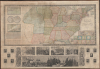

Ensign's Travellers' Guide, and Map of the United States, containing the roads, distances, Stam boat and canal routes etc.
Texas during the end of the Mexican-American War.
- Digital Map Information
- Suitable for large format printing
- Full resolution TIFF file
- ICC color profile embedded
- Delivered instantly via download link
Texas during the end of the Mexican-American War.
This is the 1847 Phelps, Ensigns and Thayer edition of Ensign's Travellers' Guide, and Map of the United States, a pictorial wall map that retains a restricted Texas at the height of the Mexican-American War (1846 - 1848). Its colored boundary follows the Nueces rather than the Rio Grande, preserving an earlier geographical conception of the very region whose disputed ownership helped precipitate the conflict. Issued during the presidency of James K. Polk, whose portrait appears below, the map combines practical transportation information with an extensive illustrated history of the republic. It is likely the rarest in this series, with no other known 1847 examples recorded.A Closer Look
The principal map extends from the Atlantic seaboard west to the Rocky Mountains and the Rio Grande, encompassing the eastern United States, the Great Plains, Texas, and part of northern Mexico. Color distinguishes states and territories, while roads and distances connect a dense network of eastern towns. The explanation distinguishes national roads, common roads, canals, and railroads, helping readers distinguish competing and complementary means of travel. The National Road is prominently labeled across the Midwest, while a route from Missouri to Mexico crosses the Plains toward Santa Fe.Thirteen inset maps beneath the title enlarge the surroundings of important transportation centers, including New York, Philadelphia, Boston, Baltimore, New Orleans, Mobile, Cincinnati, St. Louis, Charleston, Pittsburgh, Chicago, Detroit, and Washington. These are maps of urban approaches and connections rather than detailed street plans: rivers, neighboring settlements, and roads explain how each city fits into a regional travel network. Separate insets show Niagara Falls, northern Maine, and southern Florida, bringing geographically awkward extremities and a major tourist destination into the composition.
The western half presents a different informational landscape. Rivers, mountain chains, Indigenous nations, villages, and population estimates replace the eastern web of numbered roads. The Pawnees, Omahas, Otoes, Wyandots, Delawares, Shawnees, Osages, Cherokees, Creeks, and Choctaws are among the peoples identified. The phrase Great American Desert stretches across the Plains, while forts and trading settlements mark points of contact between the eastern transportation system and the continental interior.
Texas During the Mexican-American War
Texas is distinguished by pink coloring, with Austin marked as its capital and Houston, Galveston, San Antonio Bexar, Nacogdoches, and other settlements named. Austin's Colony remains prominently identified. The southwestern colored boundary follows the Nueces, then turns northeast toward the Red River, leaving a broad wedge between Texas and the Rio Grande within Mexico. Santa Fe and Albuquerque likewise remain outside Texas.This restricted outline is particularly consequential on a map dated 1847. Texas entered the United States on December 29, 1845, but Mexico rejected the annexation and had never recognized the republic's independence. Polk asserted a Rio Grande boundary, while Mexico understood Texas as a smaller region bounded in part by the Nueces. The advance of American troops into the disputed country, followed by fighting in April 1846, led to the United States' declaration of war on May 13. The present coloring preserves that smaller Texas without explaining the competing claims or illustrating the ongoing campaigns. It should therefore be understood as retained cartography, rather than evidence of a newly formulated wartime boundary proposal.
The date places this issue before the Treaty of Guadalupe Hidalgo, signed February 2, 1848, through which Mexico relinquished its claims to Texas and recognized the Rio Grande boundary. The map consequently belongs to the unsettled wartime interval.
Geography and National Memory
The left-hand column broadens the map into a compact geographical and historical reference. A double-hemisphere world map separates comparative diagrams of the world's chief rivers and principal mountains. The rivers are arranged for comparison rather than geographical position, while successive ranks of mountain profiles turn relative elevation into a miniature landscape. Below these appears the text of the Declaration of Independence, accompanied by a numbered outline key to the large historical engraving beneath the map.That lower engraving depicts the presentation of the Declaration of Independence, with four smaller scenes above illustrating the Pilgrims' landing, Lexington, Bunker Hill, and Washington's farewell to his army. Presidential portraits flank the central composition. A medallion labeled King Philip is embedded in a trophy of Indigenous weapons and ornaments at left; a portrait of James K. Polk (1795 - 1849) occupies the corresponding position amid military and national emblems at right. Polk served from 1845 to 1849, making his portrait a contemporary addition to the map's sequence of national leaders. The pairing brings the colonial past and the sitting president into the same decorative framework.
Publication History and Census
The title cartouche identifies the publishers as Phelps, Ensigns and Thayer, 36 Ann Street, New York, and explicitly dates this impression 1847. Immediately below, the map credits its steel engraving to Joseph Wells (1808 - 1874), Brooklyn, Long Island. The lower historical composition retains a Phelps and Ensign copyright inscription dated 1840, distinguishing the earlier production of that material from the publication date of the offered impression.The map belongs to a publishing lineage that included both portable travelers' maps and enlarged wall maps. The David Rumsey Map Collection documents a pocket-map edition of the associated guide in 1838, preceding the 1839 starting date sometimes given for the series. The present wall format expands that practical mapping program with western coverage, comparative geography, historical text, and a substantial pictorial surround.
This Wells-engraved issue must be distinguished from the related Pictorial Map of the United States also published in 1847 by Ensigns and Thayer. That map credits J. M. Atwood and extends to the Pacific, whereas the offered map retains the Travellers' Guide title and the older geographical framework terminating near the Rockies. Their shared year and overlapping publishers do not make them the same edition. We see no other recorded examples of this 1847 edition.
Cartographers
Edward Hooker Ensign (August 18, 1818 - July 10, 1871) was an American map, book, and print publisher based in New York City in the mid-19th century. Born in West Hartland, Connecticut in 1818, he was established in the New York publishing trade by 1839. His career developed through a succession of partnerships associated with travelers' guides, pocket maps, decorative wall maps, and historical prints. During the 1840s, he worked with Timothy Ensign under the imprint T. and E. H. Ensign and participated in the publishing enterprise Phelps, Ensigns and Thayer, whose partners included Humphrey Phelps (1799 - 1875) and Horace Thayer (b. 1811). Surviving publications demonstrate that these imprints overlapped rather than forming a simple chronological succession: an 1845 Phelps and Ensign guide, for example, accompanied a map bearing the T. and E. H. Ensign imprint. In 1851, Ensign and Thayer's travelers' guide to the western states advertised publishing addresses in both New York City and Buffalo. During the 1850s, Ensign became associated with Ensign, Bridgman and Fanning, whose partners included Thomas Coit Fanning (b. 1805). The 1857 New York directory lists both Edward H. Ensign and this firm as map dealers at 156 William Street. Its publications included state and railroad maps, illustrated geographical broadsides, and guides to western travel. At the beginning of the Civil War, the firm issued Our Nation's Camp Ground, combining maps of the mid-Atlantic region and Washington with explicitly pro-Union imagery. His various imprints include 'Phelps and Ensign' (1841-1844), 'T. and E. H. Ensign' (1844 - 1848), 'Ensign and Thayer' (1849), 'Ensign, Thayer, and Company' (1850 - 1851), 'Horace Thayer and Company' (1852), and 'Ensign, Bridgman and Fanning' (1854 - 1863). Further Details...
Humphrey Phelps (June 10, 1799 - October 8, 1875) was an American map, guidebook, broadside, and print publisher active in New York City from the early 1830s through the 1860s. Born in Hebron, Connecticut, he developed a publishing business centered on geographical information for travelers, emigrants, and urban visitors. His early New York City plan, subsequently issued as Strangers Guide through the City of New York: With the Latest Improvements, carried a copyright dated July 1, 1830. During the mid-1830s, he published with B. S. Squire, Jr., their joint imprint appearing on maps and emigrant information concerning the expanding western states. Phelps subsequently worked through several publishing partnerships: the 1847 edition of Phelps's Travellers' Guide through the United States appeared under Phelps, Ensigns and Thayer, while Phelps, Fanning and Company issued Fanning's Illustrated Gazetteer of the United States and Phelps' Hundred Cities and Large Towns of America in 1853. His output ranged from portable folding maps and city guides to decorative geographical sheets, including Pictorial View of the World, copyrighted in 1846. He also participated in the market for historical and popular prints. With his nephew Gaylord Watson (1833 - 1896), he operated Phelps and Watson, a New York map and print publishing concern that distributed Kellogg lithographs during 1859 - 1864; this partnership dissolved on January 1, 1865. Phelps returned to Hartford, Connecticut, in 1868 and died there in 1875. Further Details...
Horace Thayer (June 29, 1811 - March 15, 1875) was an American map publisher and lithographer active in New York City, Buffalo, and Warsaw, New York, during the middle of the 19th century. Born in Hartwick, New York, he married Harriet Margaret Dodge (1814 - 1870) on February 20, 1833. He moved from Warsaw to New York City in 1845 and entered a short-lived association with the Kellogg lithographers, publishing as Kelloggs and Thayer in 1846 - 1847. His cartographic business specialized in travel guides, wall maps, and pocket maps, often drawing upon existing cartographic compilations. During the 1840s and early 1850s he worked with Timothy Ensign (1795 - 1849) and Edward Hooker Ensign (1818 - 1871), whose changing partnerships produced the imprints Ensigns and Thayer, Ensign and Thayer, and Ensign, Thayer, and Company. He subsequently published as Horace Thayer and Company. His business combined map publishing with the manufacture of map rollers, the wooden fittings used to mount wall maps. He returned to Warsaw in the 1850s to establish a map-roller manufactory while continuing his connections with New York publishing. In the late 1850s and early 1860s, he collaborated with George Woolworth Colton (1827 - 1901), son of Joseph Hutchins Colton (1800 - 1893); their publications included maps bearing the Thayer and Colton imprint. His various imprints included Kelloggs and Thayer (1846 - 1847), Ensigns and Thayer (1848), Ensign and Thayer (1849 - 1850), and Ensign, Thayer, and Company (1850 - 1851), Phelps and Watson (1859), and Thayer and Colton (1859-186?). Thayer's New York business addresses included 50 Ann Street and 18 Beekman Street, the latter appearing on his 1861 village map of Warsaw. He also invested in Warsaw real estate, purchasing farmland in 1853 and a house in 1864, and later operated a map-roller establishment in nearby Johnsonburg. Following his first wife's death, he married Mary O. Tuttle on June 19, 1872. Thayer drowned in Tonawanda Creek on March 15, 1875. Further Details...
Joseph Wells (April 8, 1808 - October 5, 1874) was an English-American line and map engraver based in Brooklyn, New York, during the middle of the 19th century. Born in Birmingham, England, he learned line engraving before emigrating to the United States on August 28, 1837, and settling in Brooklyn. His cartographic work included steel-plate engraving for the New York publishers Phelps and Ensign. Their 1841 Phelps and Ensign's Travellers' Guide, and Map of the United States, Containing the Roads, Distances, Steam Boat and Canal Routes &c. explicitly credits J. Wells of Brooklyn with engraving the map on steel. This work documents his participation in the production of American transportation maps during the expansion of railroad, canal, and steamboat travel. The Brooklyn city directory for 1852 - 1853 lists Joseph Wells as an engraver on Navy Street near Myrtle Avenue. He continued working as an engraver until about 1870 and died on October 5, 1874. Further Details...
Condition
Good. Wall map. Fully restored with fresh linen backing. Crackling from old varnish (removed).
References
Rumsey, 4490.003. Related 1838 pocket-map edition. Rumsey, 5380.000. Related 1847 Atwood pictorial map, not the offered Wells-engraved edition. Wilson, Walter E., 'The Shapes of Texas: The Cartographic Evolution of an Icon', The Portolan, No. 54 (Fall 2002), pp. 40 - 41.