This item has been sold, but you can get on the Waitlist to be notified if another example becomes available, or purchase a digital scan.
1939 Jaro Hess Pictorial Map of the Land of the New Testament
LandNewTestament-hess-1939$475.00

Title
The Land of the New Testament.
1939 (dated) 18.25 x 26.25 in (46.355 x 66.675 cm)
1939 (dated) 18.25 x 26.25 in (46.355 x 66.675 cm)
Description
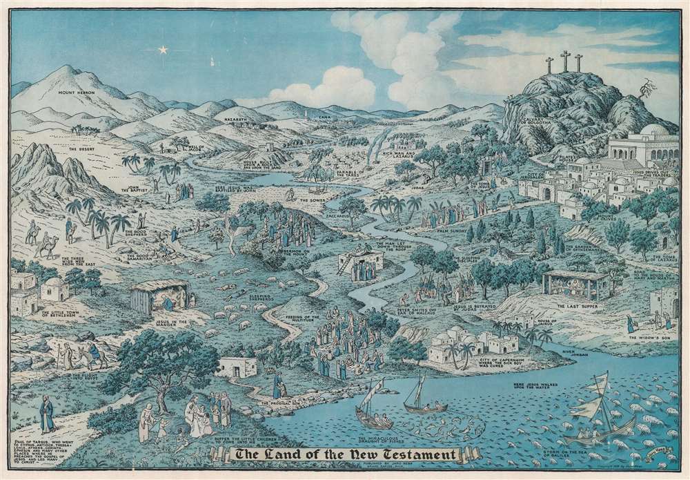
This is the rare 1939 Jaro Hess pictorial view and map of the land of the New Testament - the second and scarcest of Hess's two known maps. Like his more famous Land of Make Believe, Hess populates the terrain with vignettes from the Gospels are illustrated throughout the piece, including Jesus in the Manger, the Flight into Egypt, the Sermon on the Mount, Palm Sunday, the Last Supper, and Jesus's Betrayal by Judas. The Cavalry of Golgotha and the three crosses draw the eye to the upper right. John the Baptist, the Good Shepherd, the Good Samaritan, and Paul of Tarsus appear. Important Biblical locations, such as Jerusalem, Bethlehem, and Nazareth, are interspersed amongst the illustrated events.
Publication History and Census
This map was created and published by Jaro Hess in 1939. This map is rare. We note only one example cataloged in OCLC, at Minnesota State University, Mankato. We note only a handful of instances when this map has appeared on the private market in recent years.Cartographer
Jaro Hess (March 22, 1889 - 1977), was a Czech painter and landscape designer. Hess was born in Prague, where he was named Jaroslav Hes. He immigrated to the United States in 1910, at the age of 21. Before immigrating, Hess received a degree in metallurgical engineering from the University of Prague, and soon thereafter joined the French Foreign Legion in Algiers. He quickly realized that this had been a poor decision and later remembered the experience as some of the ‘worst days of his life.’ After returning to Europe as a stowaway, he completed his military service in the Austrian army. After immigrating to America, Hess tried his luck in the Pittsburgh steel mills. He greatly disliked the ‘dirty city’ and left, embarking on a more circuitous and nomadic life, working as a chemist, engraver, horticulturist, and steelworker throughout the Midwest. Hess eventually ended up in Grand Rapids, Michigan, where he took over his father-in-law’s plant nursery. Over the course of the 1930s and 40s, Hess made a name for himself as an artist in the Grand Rapids artistic community, and drew his most famous work, The Land of Make Believe. Hess became known for his sketches of odd creatures and other supernatural themes. More by this mapmaker...
Condition
Very good. Closed margin tear professionally repaired on verso. Verso reinforcements in upper right corner. Residue from old tape repair evident in lower margin.
References
OCLC 4224900.