This item has been sold, but you can get on the Waitlist to be notified if another example becomes available, or purchase a digital scan.
1960 Faller Pictorial Map of Germany as Fairytale Land
LandOfFairytales-faller-1960$150.00

Title
With the German Federal Railroad Through the Land of Fairytales.
1960 (undated) 32.5 x 23 in (82.55 x 58.42 cm) 1 : 1100000
1960 (undated) 32.5 x 23 in (82.55 x 58.42 cm) 1 : 1100000
Description
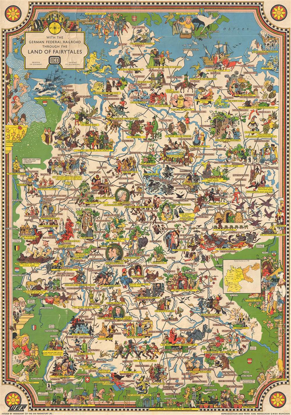
This is a c. 1960 reprint of a 1937 Leo Faller pictorial map of Germany illustrating many of its fairy tales. Celebrated for its fairy tales, the map depicts Germany from the Netherlands, Belgium, and France to Berlin and the Czech Republic and from Denmark to Austria. By far the most renowned publishers of German fairy tales are Jakob and Wilhelm Grimm, better known as the Grimm brothers. These brothers published several editions of their renowned collection of tales. The first, published in 1812, contained 86 stories, but by the seventh edition, which was published in 1857, they had compiled 211 different fairy tales. The stories the Grimms collected were part of German oral tradition, meaning that the brothers were told these stories by individuals. Several well-known fairy tales are illustrated and labeled here, including Little Red Riding Hood, Puss in Boots, Hansel and Gretel, Cinderella, Snow White, and the Pied Piper.
The map itself is incredibly detailed, with cities and towns labeled throughout Germany and highways and rivers snaking their way across the country. The municipalities are labeled by block lettering in pink boxes, while yellow banners mark each fairy tale. Though undated, the map features an inset map entitled 'German frontiers as of 1937'. This this may appear to date the map to 1937, the labels 'Soviet Zone' and 'Democratic Republic' appear on this map, dating it firmly in the second half of the twentieth century, during the Cold War. This map was originally created by Leo Faller for the Deutsche Reichsbahn (German State Railway) and then it was reissued by the Deutsche Bundesbahn and reprinted by Karl Wenschow in Munich c. 1960.
The map itself is incredibly detailed, with cities and towns labeled throughout Germany and highways and rivers snaking their way across the country. The municipalities are labeled by block lettering in pink boxes, while yellow banners mark each fairy tale. Though undated, the map features an inset map entitled 'German frontiers as of 1937'. This this may appear to date the map to 1937, the labels 'Soviet Zone' and 'Democratic Republic' appear on this map, dating it firmly in the second half of the twentieth century, during the Cold War. This map was originally created by Leo Faller for the Deutsche Reichsbahn (German State Railway) and then it was reissued by the Deutsche Bundesbahn and reprinted by Karl Wenschow in Munich c. 1960.
Cartographer
Leo Faller (April 19, 1902 - December 15, 1969) was a German artist and painter. Born in Karlsruhe, Faller worked for the German Reichspost and the Deutsche Reichsbahn. He produced numerous works for the Reichsbahn advertising office WER. More by this mapmaker...
Condition
Good. Backed on archival tissue for stability. Exhibits some crackling. Blank on verso.
References
Rumsey 12023.000.