This item has been sold, but you can get on the Waitlist to be notified if another example becomes available, or purchase a digital scan.
1943 Harrison World War II Propaganda Map of Japanese Empire: Land of the Setting Sun
LandoftheSettingSun-harrison-1943$325.00

Title
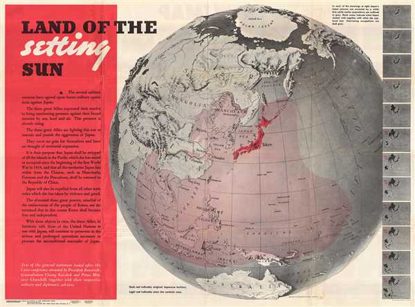
Land of the Setting Sun; Newsmap, Monday December 27, 1943.
1943 (dated) 35 x 47 in (88.9 x 119.38 cm)
1943 (dated) 35 x 47 in (88.9 x 119.38 cm)
Description
An iconic American World War II propaganda broadside map by the cartographic innovator Richard Edes Harrison illustrating, as projected on the hemisphere, the expansion of the Japanese Empire. The broadside, Land of the Setting Sun, formally entitled Newsmap. Monday, December 27, 1943, Vol. II No. 36, illustrates the rapid militaristic expansion of the Japanese Empire from 1914 to December of 1943. A series of maps to the right of the primary image follow Japan's Pacific conquests from 1875 to present. A statement, to the right of the map, outlines the intention of the Allied Powers in Asia (United States, Great Britain, and China), to curtain Japanese imperialism and return that nation to its original 1814 borders.
The verso of the maps features a segmented breakdown of the most recent war news on various fronts. Most of it is quite good for the Allies. Following a series of Allied victories in Italy, Russia, at Stalingrad, in East Asia, and Indonesia, the War had, by this date, turned firmly against the Axis powers. As such, there was little need for 'sugar coating' and the general message was, in as much as war can be, truthfully positive.
Weekly 'Newsmaps' were published by the Army Orientation Course of the Special Service Division Army Service Forces, a propaganda arm of the United States War Department. The Newsmaps typically employed bold typesetting and dramatic imagery to relay the most recent war news from a distinctly 'positive' perspective. Nonetheless, few Newsmaps were as dramatic or impactful this one by Richard Edes Harrison, whose distinctive style, evident here, many consider to have revolutionized modern journalistic cartography.
Cartographer
Richard Edes Harrison (1902 - January 5, 1994) was an American cartographer and cartoonist active in the middle part of the 20th century. Harrison is credited with redefining cartography, especially journalistic cartography, by employing spherical perspective, bold shading, and graphic design to both make maps more publicly accessible and give them an artistic dimension. Harrison was born in Baltimore and studied design at Yale, graduating in 1923, before relocating to New York City at the height of the Great Depression. He made ends meet through industrial design work, creating everything from bottles to ashtrays. His first foray into the cartographic world was a fill-in job at Fortune magazine. The editors at Fortune must have admired his work for it launched a long-standing collaboration. His work, doubtless inspired by the age of air travel, became exceptionally popular during World War II, where his unique approach and political charged subject matter illustrated the seats of war with exceptional poignancy and clarity. After the war, Harrison continued to produce maps from his base in New York City. In his spare time he was an avid ornithologist and was commonly seen in Central Park in search of rare bird sightings. More by this mapmaker...
Condition
Very good. Minor wear along original fold lines, especially at fold intersections, where there is minor verso reinforcement in 2 or 3 places. Else very clean examples.