1707 J. B. Homann Map of Provence, France
LaProvence-homann-1707$850.00

Title
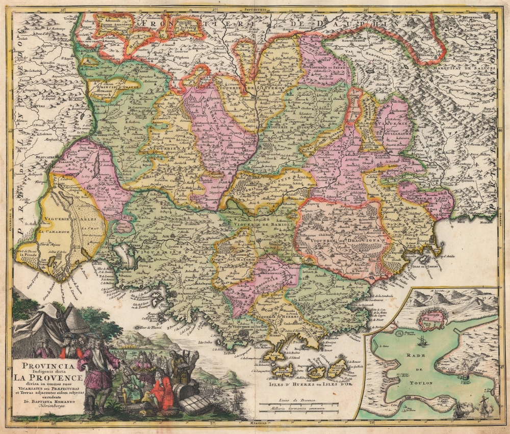
Provincia Indigenis dicta La Provence divisa in omnes suos Vicariatus seu Praefecturas et Terras adjacentes eidem subjectas excudente Io. Baptista Homanno.
1707 (undated) 19 x 22.5 in (48.26 x 57.15 cm) 1 : 408000
1707 (undated) 19 x 22.5 in (48.26 x 57.15 cm) 1 : 408000
Description
This is a 1707 Johann Baptist Homann map of Provence, France, featuring outstanding original color. Published during the War of the Spanish Succession (1701 - 1714), this map was issued in the wake of the Siege of Toulon, a 1707 battle in the War of Spanish Succession (1701 - 1714).
A Closer Look
Encompassing southeastern France and extreme northwestern Italy, the map depicts from Nimes east to Pinerolo (Pignerole) and from Viviers south to the Mediterranean. Marseille, Toulon, Nice, Saint Tropez, Arles, and Avignon appear. The Camargue, today famous for its wildlife (including wild horses and flamingoes), is identified near the left border. An inset in the lower right focuses on Toulon. Allied forces are illustrated throughout, bombarding Toulon and other French positions. The Allied navy appears at the mouth of the harbor, while the French fleet lies at anchor. The title cartouche in the bottom left features illustrations of European nobles receiving war spoils as Toulon burns. The bombardment of Toulon is illustrated in the lower right portion of the cartouche.1707 Siege of Toulon
The 1707 siege of Toulon was fought during the War of the Spanish Succession (1701 - 1714) and took place between July 29, 1707, and August 21, 1707. A combined force of Austrian and Savoyard ground troops supported by a fleet of British and Dutch warships attacked Toulon, a French stronghold on the Mediterranean coast of France. The Allies hoped to capture the city and open France to attack from the south, circumventing France's stout northern defenses. French King Louis XIV ordered 46 French ships of the line scuttled in order to avoid the fleet's complete destruction. Upon reaching Toulon, the Allies were outnumbered and lacked sufficient men or artillery to mount a full siege. They successfully captured the Santa Catarina heights overlooking the city (illustrated in the inset and labeled (M. de S. Catharine) but were dislodged by the French four days later. In the end, the Allies were forced to retreat, with French forces threatening their rear and over 13,000 casualties (mostly caused by disease) depleting their strength. Before withdrawing, the British fleet bombarded Toulon for 18 hours, destroying the dockyards and naval stores necessary to repair the French fleet. While neither side officially won the battle, it was a decisive strategic defeat for the Allies, due to high casualties and a stalemate along France's well-fortified northern border. Nonetheless, the British did gain complete control of the western Mediterranean since the French lost their fleet, as the scuttled ships were not refloated until after the war.Publication History and Census
This map was published c. 1707 by Johann Baptist Homann for inclusion in his Neuer Atlas. The present example is from a 1710 edition of the Neuer Atlas. The separate map is well represented in institutional collections and cataloged in over one dozen entries in the OCLC.Source
Homann, J. B., Neuer Atlas bestehend in einig curieusen Astronomischen Kuppren und vielen auserlesenen accuratensten Land-Charten über die Gantze Welt, (Nuremberg: Homann), 1710.
Homann's Neuer Atlas bestehend in einig curieusen Astronomischen Kuppren und vielen auserlesenen accuratensten Land-Charten über die Gantze Welt was first publihsed in 1707 with 33 maps. A second edition followed in 1710 with 60 maps. Subsequent editions followed until about 1730. The title page notes proudly that the atlas features measurements based on the 'Copernican principle of the moving sky', a truly state-of-the-art innovation for the period. Regardless of editions, collations of the atlas are inconsistent, with some examples having less, while others have more maps - a consequence of the fact that the map sheets were delivered loose, to be bound at the buyer's discretion, and so some buyers chose to omit maps they did not consider relevant, or add others they did. Between editions, the constituent maps, particularly of European regions, were regularly updated to reflect the most recent political events. The atlas continued to be published by Homann's son, J. C. Homann (1703 - 1730), and then by Homann Heirs. Most examples also feature a fine allegorical frontispiece with the title Atlas Novus Terrarum Orbis Imperia, regna et Status, which was used for multiple Homann atlases, including the Neuer Atlas and the Atlas Minor.
Condition
Very good. Verso repair to centerfold separation. Printer's crease through title cartouche. Superb original color.
References
OCLC 552084546. Rumsey 12499.078 (1716 state).