
This item below is out of stock, but another example (left) is available. To view the available item, click "Details."
Details
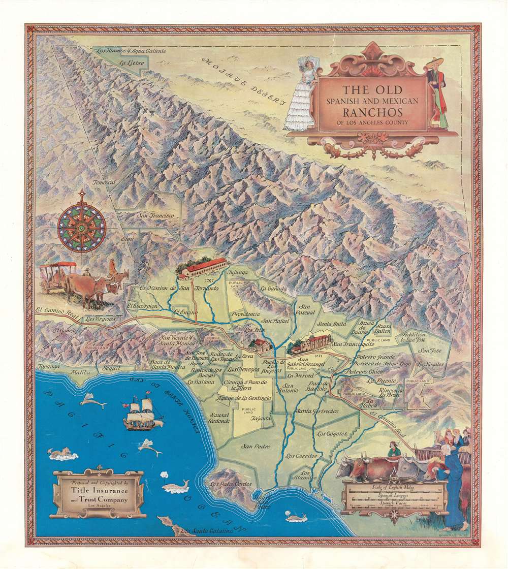
1937 Eddy Pictorial Map of Los Angeles County Ranchos
$550.00
1937 Eddy Pictorial Map of Los Angeles County Ranchos
LARanchos-eddygerald-1937$275.00

Title
The Old Spanish and Mexican Ranchos of Los Angeles County.
1937 (dated) 20 x 17.5 in (50.8 x 44.45 cm) 1 : 295000
1937 (dated) 20 x 17.5 in (50.8 x 44.45 cm) 1 : 295000
Description
This is a fanciful 1937 Gerald Eddy pictorial map of the historic Spanish and Mexican ranchos of Los Angeles County, the names of which were later applied to neighborhoods and towns. Eddy's work fits within a broader cultural movement in Southern California in the early-mid 20th century, often labeled Spanish Revival, that grasped at an idealized vision of California's past, creating something unique and idiosyncratic.
Vignette illustrations appear around the edges of the map, including a cartouche at top-right. Native Americans, who constituted the vast majority of the population of Alta California, make no appearance, while the Spanish friars, rancheros, and settlers are inaccurately depicted as both entirely white and equally balanced between men and women.
Hardly the most luxurious place in the Spanish Empire, the area struggled to attract immigrants. Despite the tensions with the native population and the strict racial hierarchy in Spanish America, the nature of frontier society prevailed. Roughly half the early Spanish colonists in the L.A. region were of partial Indian or African heritage, a trend which would continue as most rancheros had Indian or mixed-race wives and mistresses. No individual represents the contradictions of colonial society better than Pio Pico, who was born in California as a Spanish subject, lived much of his life under independent Mexico, and died an American citizen. Pico was one of the wealthiest men in California prior to the Mexican-American War (1846 - 1848), owning land in several parts of California (including the Rancho Paso de Bartolo here), and was the last governor of Mexican Alta California. He was also of mixed Indian, European, and African heritage. After California was incorporated into the U.S., Pico built a grand residence near the Pueblo de Los Angeles and settled down to what should have been a comfortable retirement, but gradually lost his fortune to bad luck, gambling, and fraud.
After 1848, the 'Anglos' displaced the old 'Californio' elite of Alta California and launched a campaign of ethnic cleansing and genocide against the native population. While northern California prospered in the Gold Rush, L.A. continued to function primarily as a provider of livestock and beef, but now with a violent 'Wild West' town of bandits, drifters, and grifters at its core, prone to outbursts of collective violence against Native Americans, Chinese, and Mexicans. In the late 19th century, efforts were made to give the city a more respectable image and attract a better class of migrants from further east. The massive public relations campaign known as 'boosterism' succeeded in pitching Southern California as a sunny palm tree-laden paradise of boundless land suited for agriculture and ripe with opportunities in other industries, especially oil. These endeavors were greatly aided by the development of Southern California's railway and irrigation infrastructure. Still a town of barely 11,000 in 1880, the population of Los Angeles exploded to more than 300,000 by 1910, then to more than 1.2 million by 1930.
A Closer Look
This map, oriented towards the northeast looking over the San Gabriel Mountains, marks out the large ranchos doled out to Spanish (and after 1821, Mexican) rancheros in Alta California - the Californios. The names of many ranchos are retained in the modern-day neighborhoods, towns, beaches, boulevards, and canyons of metropolitan Los Angeles. Three early Spanish structures, the missions of San Gabriel and San Fernando along with the Pueblo de Los Angeles, are indicated with the dates. Scales are given in English miles, Spanish leagues, and Spanish varas.Vignette illustrations appear around the edges of the map, including a cartouche at top-right. Native Americans, who constituted the vast majority of the population of Alta California, make no appearance, while the Spanish friars, rancheros, and settlers are inaccurately depicted as both entirely white and equally balanced between men and women.
Los Angeles in the Spanish and Mexican Eras
Originally inhabited by the Tongva people, the area that now includes Los Angeles had been claimed by Spain since the 1540s but had no permanent Spanish presence until the 1770s, when competing interests sought to establish religious missions, military bases (presidios), and secular settlements (pueblos). The behavior of the colonists toward the native population caused significant tensions with both the religious missions (San Gabriel and San Fernando) and pueblo of Los Angeles, leading to multiple revolts. The economy of the area came to revolve around agricultural production, especially raising cattle on vast ranches overseen by a small circle of Spanish elites.Hardly the most luxurious place in the Spanish Empire, the area struggled to attract immigrants. Despite the tensions with the native population and the strict racial hierarchy in Spanish America, the nature of frontier society prevailed. Roughly half the early Spanish colonists in the L.A. region were of partial Indian or African heritage, a trend which would continue as most rancheros had Indian or mixed-race wives and mistresses. No individual represents the contradictions of colonial society better than Pio Pico, who was born in California as a Spanish subject, lived much of his life under independent Mexico, and died an American citizen. Pico was one of the wealthiest men in California prior to the Mexican-American War (1846 - 1848), owning land in several parts of California (including the Rancho Paso de Bartolo here), and was the last governor of Mexican Alta California. He was also of mixed Indian, European, and African heritage. After California was incorporated into the U.S., Pico built a grand residence near the Pueblo de Los Angeles and settled down to what should have been a comfortable retirement, but gradually lost his fortune to bad luck, gambling, and fraud.
After 1848, the 'Anglos' displaced the old 'Californio' elite of Alta California and launched a campaign of ethnic cleansing and genocide against the native population. While northern California prospered in the Gold Rush, L.A. continued to function primarily as a provider of livestock and beef, but now with a violent 'Wild West' town of bandits, drifters, and grifters at its core, prone to outbursts of collective violence against Native Americans, Chinese, and Mexicans. In the late 19th century, efforts were made to give the city a more respectable image and attract a better class of migrants from further east. The massive public relations campaign known as 'boosterism' succeeded in pitching Southern California as a sunny palm tree-laden paradise of boundless land suited for agriculture and ripe with opportunities in other industries, especially oil. These endeavors were greatly aided by the development of Southern California's railway and irrigation infrastructure. Still a town of barely 11,000 in 1880, the population of Los Angeles exploded to more than 300,000 by 1910, then to more than 1.2 million by 1930.
Spanish Revival
With most of the city's population being born elsewhere, L.A. faced an identity crisis in the early 20th century. One solution was to turn to the city's history, or at least a fabricated version of it. The image of Southern California presented by boosters incorporated romanticized depictions of the area's Spanish and Mexican past, especially Spanish-built missions and villas. The most obvious impact of this concocted nostalgia was in architecture, both in public spaces, as with many of the grandiose railway stations, government buildings, and movie theaters built in this era, and in private residences, as migrants from the Midwest who prospered in L.A. built 'Spanish-style' homes in the city's growing suburbs. A concurrent movement occurred in the visual arts, of which this map is a prime example.Publication History and Census
This map was drawn by Gerald Eddy and published in 1937 by the Title Insurance and Trust Company. It is held by a handful of universities and research institutions in California and elsewhere in the United States and is scarce to the market.Cartographer
Gerald Allen Eddy (October 12, 1889 - September 9, 1967) was an American artist. Born in Michigan, Eddy's parents either divorced or his father died between 1900 and 1910. In 1910 Eddy was living with his mother, brother, and stepfather in Los Angeles and working as an artist. Eddy was a prolific cartographer and created numerous maps of different areas of the western United States. He was married and had a daughter by 1917, according to his World War I draft card. He was married to his wife Madolyn when he died. More by this mapmaker...
Condition
Very good. Minor toning in bottom margin.
References
Rumsey 8619.000. OCLC 24537772, 64401440.