This item has been sold, but you can get on the Waitlist to be notified if another example becomes available, or purchase a digital scan.
1892 Wellge Bird's-Eye View of Laredo, Texas
LaredoView-wellge-1892$11,000.00


Title
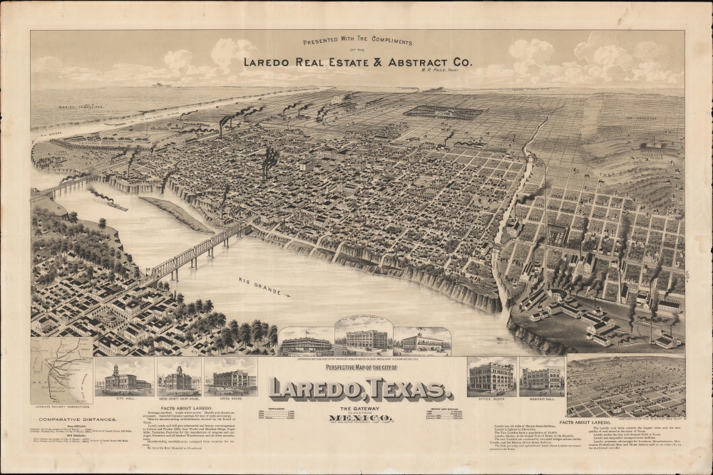
Perspective Map of the City of Laredo, Texas. The Gateway to and from Mexico.
1892 (undated) 19.75 x 33 in (50.165 x 83.82 cm)
1892 (undated) 19.75 x 33 in (50.165 x 83.82 cm)
Description
A very rare broadside bird's-eye view map of Laredo, Texas. The map was issued on Laredo's quadranscentennial, and so reflects a 25-year period of breakneck growth and prosperity, from which Laredo emerged as the most prosperous and connected border city in south Texas.
Vignettes along the lower portion of the sheet show prominent buildings: City Hall, Webb County Court House, the Hotel Hamilton, the Laredo Improvement Company, and the Masonic Hall. Text below the view offers 'Facts about Laredo,' ranging from population and industrial data, to declarations that Laredo produces the 'best and cheapest bricks in Texas'. A submap in the lower right further details 'The Heights', a slightly elevated plateau to the northeast of the city center. Far from the industrial center, this area was intended as an elite suburb of grand mansions, but today is occupied by the Laredo Airport.
City views were being produced in the United States as early as the 1830s, but the genre exploded after the American Civil War (1861 - 1865). Bridging the gap between maps and pictures, most 19th century American bird's-eye views presented cities to the public from highpoints. Some were imagined, but others were drawn from hot-air balloons or nearby hills. The presentation, combining high elevation, commercial interest, and new printing technology created a uniquely American art form, as described by historian Donald Karshan,
A Closer Look
The view looks northwest on Laredo from an imaginary high point above Nuevo Laredo, Mexico, just across the Rio Grande. While development extends inland as far as modern-day Washington Street, the city grid stretches outwards in all directions underscoring great expectations for urban growth. Plans for expansion included a grand public park at Convent and Park Street, an area today repurposed for the Laredo Public School System and Shirley Field.Vignettes along the lower portion of the sheet show prominent buildings: City Hall, Webb County Court House, the Hotel Hamilton, the Laredo Improvement Company, and the Masonic Hall. Text below the view offers 'Facts about Laredo,' ranging from population and industrial data, to declarations that Laredo produces the 'best and cheapest bricks in Texas'. A submap in the lower right further details 'The Heights', a slightly elevated plateau to the northeast of the city center. Far from the industrial center, this area was intended as an elite suburb of grand mansions, but today is occupied by the Laredo Airport.
Historical Context
The view was sponsored by Laredo Real Estate and Abstract, a development company founded by W. R Pace. Laredo was initially founded in 1775 by the Spanish to pre-empt French immigration from Louisiana. Although little more than a border settlement, Laredo grew throughout the second half of the 19th century as a ranching hub and border town. Coal was discovered nearby in the 1880s. In 1881, to service coal and cattle, the Texas Mexican Railroad extended tracks from Corpus Christi, and the International-Great Northern Railroad built a line from San Antonio. The Rio Grande and Pecos Railroad followed in 1884, making Laredo the only border town connected with international railroad networks in the lower Rio Grande - a fact highlighted her via an inset in the lower left.American Bird's-Eye City Views
The Bird's-Eye view industry emerged in the United States in the middle part of the 19th century and coincided with the commercial development of lithographic printing. Before the rise of lithography, the ability to own and display artwork in the home was largely limited to the extremely wealthy, but the advent of lithographic printing made it possible for everyone to own visually striking artwork. A robust trade developed in portraits of political leaders, allegorical and religious images, and city views.City views were being produced in the United States as early as the 1830s, but the genre exploded after the American Civil War (1861 - 1865). Bridging the gap between maps and pictures, most 19th century American bird's-eye views presented cities to the public from highpoints. Some were imagined, but others were drawn from hot-air balloons or nearby hills. The presentation, combining high elevation, commercial interest, and new printing technology created a uniquely American art form, as described by historian Donald Karshan,
Some print connoisseurs believe that it was only with the advent of the full-blown city-view lithograph that American printmaking reached its first plateau of originality, making a historical contribution to the graphic arts. They cite the differences between the European city-view prints and the expansive American version that reflects a new land and a new attitude toward the land.The vogue for bird's-eye city views lasted from about 1845 to 1920, during which period some 2,400 cities were thus portrayed, some multiple times. Although views were produced in many urban centers, the nexus of view production in the United States was Milwaukee, Wisconsin. The major American viewmakers were Stoner, Wellge, Bailey, Fowler, Hill Ruger, Koch, Burleigh, Norris, and Morse, among others.
Publication History and Census
This view was drawn by Henry Wellge and published under the imprint of his American Publishing Company, Milwaukee, Wisconsin. It was issued on the 25th anniversary of the city's founding on behalf of the Laredo Real Estate and Abstract Company. This view is rare. Reps locates just two copies, at the Library of Congress and the Amon Carter Museum. OCLC adds one more at Penn State. We are aware of one additional example held privately.Cartographer
Henry Wellge (1850 – 1923) was an American panoramic bird's-eye view publisher, artist, and cartographer active in Milwaukee in the late 19th and early 20th century. Wellge was born in Germany in 1850. His first view, in 1878, was of Chilton Wisconsin, but most of his early work is in association with J. J. Stoner, another prolific view maker. Eventually established his own firm Henry Wellge and Company. Later his published and Norris, Wellge and Company. Ultimately though, most of his work appears under the imprint of the American Publishing Company. He continued to publish views until about 1910 with about 152 views bearing his imprint. Wellge is known for large dramatic views illustrated with emphasis on the horizontal dimension. More by this mapmaker...
Condition
Very good. Some excellent restoration and verso reinforcement where originally folded and here and there in margins.
References
Amon Carter Museum, 1975.86. Reps, John, Views and Viewmakers of Urban America (University of Missouri, Columbia, 1984), #3985.