This item has been sold, but you can get on the Waitlist to be notified if another example becomes available, or purchase a digital scan.
1852 Stansbury Map: Great Salt Lake to Fort Leavenworth Route, Presentation Edition
LeavenworthGreatSaltLake-stansbury-1852-3$1,250.00

Title
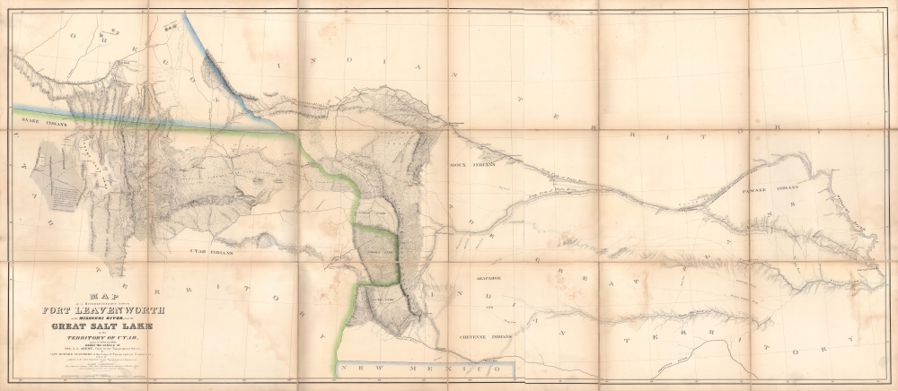
Map of a Reconnaissance between Fort Leavenworth and the Missouri River, and the Great Salt Lake in the Territory of Utah, made in 1849 and 1850…
1852 (dated) 30 x 68 in (76.2 x 172.72 cm) 1 : 1000000
1852 (dated) 30 x 68 in (76.2 x 172.72 cm) 1 : 1000000
Description
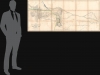
A monumental map, matching the landscape it depicts, this is Howard Stansbury's seminal map of the lands between Fort Leavenworth, Kansas, and Pilot Peak (now Nevada), west of the Great Salt Lake. Originally published in 1852 as part of the Stansbury Report presented to the U.S. Congress that year, the present example is mounted on linen and folds into a case, as it was intended for a member of Congress. This is hand-down the finest example we've seen of this map, and if you are considering it for your collection, this is the one you want.
Stansbury's Report was received with great acclaim in Washington. Gunnison, Stansbury's second, was commissioned to return to the region the next year to survey a viable route for the Pacific Railroad. In the process of completing this project, Gunnison and several other members of his party were killed by local Ute Indians, who likely mistook them for Mormons, with whom they were engaged in a low-level war. The attack delayed the survey and the development of the Pacific Railroad for several years.
A Closer Look
Covering the modern-day states of Kansas, Colorado, Wyoming, and Utah, this map details the whole of the 1849 to 1851 journey of Stansbury and his team, which is tracked by red lines with dates noted. Stansbury's map is the result of an enormous feat of exploration and scientific tenacity. The detail throughout is extraordinary, identifying mountains, springs, rivers, passes, American Indian settlements, canals, etc. Stansbury's work and this map are responsible for creating much of the region's nomenclature, but where it is not, both Mormon and American Indian names are provided. In addition to its major contribution to the cartography of the American West writ large, this map is also one of the earliest to delineate the street grid of Salt Lake City (still as 'Great Salt Lake City' here).Euro-American Discovery of the Great Salt Lake
The first Westerner to visit the Great Basin was most likely Silvestre Vélez de Escalante in 1776. However, Escalante, who visited Utah Lake to the south, never truly laid eyes on Great Salt Lake. That honor would fall to unnamed trappers and mountain men traveling the region in search of furs and other tradable commodities. Unfortunately, few of these men were literate and did not record their discoveries. The first scientific expedition to this area was headed by John C. Frémont in 1843. Daunted by the season and climate, Frémont never circumnavigated the lake. That task fell to Howard Stansbury who, in 1849, was assigned by Congress to survey the Great Salt Lake, the Utah Valley, and the emigrant roads passing through the region. Stansbury, working with Gunnison, Carrington, and others, took about two years to complete his survey before presenting it to Congress in 1852. This map was part of that presentation.Stansbury's Report was received with great acclaim in Washington. Gunnison, Stansbury's second, was commissioned to return to the region the next year to survey a viable route for the Pacific Railroad. In the process of completing this project, Gunnison and several other members of his party were killed by local Ute Indians, who likely mistook them for Mormons, with whom they were engaged in a low-level war. The attack delayed the survey and the development of the Pacific Railroad for several years.
Publication History and Census
This map was drawn by army officers John W. Gunnison and Charles Preuss and published in 1852 as part of the Stansbury Report (full title: Exploration and Survey of the Valley of the Great Salt Lake of Utah). It is a crucial map of 19th century America, a must for any serious cartographic collection focusing on the Great Salt Lake or the American West. This example is especially appealing given its condition and format, a linen-backed folding map, as opposed to other examples on the market and institutional collections, which were printed on low-quality easily-damaged paper and folded into the report. The name Milton Dimmick appears on the inside of the case; his father, Milo Melankthon Dimmick, was a member of the House of Representatives at the time of the report's publication, which likely explains the unusually careful presentation of this example.CartographerS
Howard Stansbury (February 8, 1806 - April 13, 1863) was an important surveyor, cartographer, and explorer who did his most important work in Utah during the middle part of the 19th century. Born in New York City, Stansbury trained to be a Civil Engineer. Shorty after getting married to Helen Moody of Detroit in 1827, Stansbury took a position with the United States Topographical Bureau. Under that organization he surveyed the James River in 1836, and the Illinois and Kaskaskia Rivers in 1837. In 1838, he oversaw the construction of a road from Milwaukee to the Mississippi River. Later in 1838, when the U.S Corps of Topographical Engineers was created, he joined as a first Lieutenant. With the Topographical Engineers he surveyed the Great Lakes, the harbor of Portsmouth, New Hampshire, and constructed Florida's Carysfort Reef Lighthouse. During the Mexican-American War he constructed fortification in the Dry Tortugas at the westernmost point on the Florida Keys. Upon achieving the rank of Captain, Stansbury received a commissioned to head a survey of the Great Basin that would ultimately become the crowning achievement of his career. His assignment was to survey the emigrant trails to California, including the Oregon Trail, as well as the Great Salt Lake, and report on the status of the growing Mormon Community in Salt Lake City. Working with J. W. Gunnison and Alfred Carrington, a Mormon scout, Stansbury produced a masterful survey of the region that had a lasting effect not only on the development of the Great Basin, but on the development of the west in general. Upon completion of his survey, Stansbury set out on the road to Washington, completing another important survey in the process. On the way, he fell off his horse, taking an injury from which he never fully recovered. Following the presentation of his report to Congress, Stansbury was charged with additional survey work around the Great Lakes. Upon the outbreak of the American Civil War, he was assigned to recruitment duties in Ohio and later Wisconsin. Shortly after starting work at this post he suffered an abrupt heart attack and passed away. He is buried in St. Paul, Minnesota. More by this mapmaker...
Charles Preuss (1803 - September 2, 1854), or as he was born George Karl Ludwig Preuss, was a German-born lithographer and cartographer who produced several important maps of the American West in the middle part of the 19th Century. Preuss was born in Hohscheid, Germany, where grew up and studied the science of Geodesy. There he also studied lithography with its inventor, Aloys Snefleder. After mastering the art, he worked under the Prussian Government as a mapmaker and surveyor. Preuss immigrated to the United States with his wife and children in 1834. In the United States, he worked at a few minor drafting positions before taking work under Ferdinand Hassler and the U.S. Coast Survey. Hassler introduced Preuss to Captain John Charles Fremont, who was then planning his landmark surveying expedition to the American West. Impressed with Preuss' work, Fremont hired him as the expedition's cartographer. Preuss seems to have been singularly unimpressed with Fremont and the American West, complaining bitterly in his journals about both. He considered Fremont "childish" and the scenery "dull" and "lackluster." Nonetheless, he was convinced to participate in one expedition after another, and the maps he produced, both under Fremont and under Stansbury, were among the most important maps of the region ever drafted. These include, among many others, the first map of the Oregon Trail, the first accurate mapping of the Great Salt Lake, the naming of the Golden Gate, and the first identification of the California Gold region. Preuss's maps influenced North American cartography for the next two decades. Kemble Warren, who assembled Preuss' maps as well as the work of many others into his "General Map" of the American West, said of Preuss, "his skill in sketching topography in the field and in representing it on the map has never been surpassed in this country." Ultimately, despite his many successes, the admiration of his peers, and a life of adventure, Preuss seems to have suffered from chronic depression, apparently the result of sunstroke in California. In September of 1854, he hung himself from a tree limb in Washington, D.C. Learn More...
John Williams Gunnison (November 11, 1812 - October 26, 1853) was a surveyor and officer in the U.S. Army. Born in New Hampshire, he attended West Point starting in 1837 and graduated second in his class. After serving as an artillery officer in fighting against the Seminoles in Florida, he was reassigned due to health reasons and joined the Army's Corps of Topographical Engineers. He spent most of the 1840s surveying lands around the Great Lakes, and in 1849 served as second-in-command to Howard Stansbury's expedition to map the Great Salt Lake. In addition to his cartographic work, Gunnison spent considerable time interacting with Mormons and wrote a book about the people and their religion on returning to Washington D.C. After additional surveying work around the Great Lakes in present-day Wisconsin, in 1853 Gunnison was assigned to lead an expedition to survey a railroad route through Utah (the Gunnison–Beckwith Expedition). While doing so, he was killed in a massacre committed by Pahvant Ute Indians, who had likely mistaken his surveying team for a group of Mormons, with whom the Pahvant were fighting a low-level war (the Walker War). In the context of existing tensions between the U.S. Government and Mormon settlers, rumors swirled that Brigham Young had orchestrated the massacre to prevent the railroad's construction, a charge which later investigations found to be baseless, but which nevertheless was widely believed at the time. The incident was one of several that increased mistrust between Mormons and the U.S. Government in the lead up to the Utah War of 1857 - 1858. Learn More...
James Ackerman (1816 - March 24, 1864) was an American painter, engraver, and lithographer active in New York City in the mid-19th century. Ackerman was born in New York. He rose to prominence as a lithographer and painter - best known for his floral prints, some of which were favorably lauded by none other than Edgar Allen Poe. He was also associated with the banner and sign painting firm of Ackerman and Miller until his death. His offices were at 120 Fulton Street and later at 379 Broadway. He frequently printed for the U.S. government, including work for the U.S. Coast Survey and the General Land Office. I have found few references to what happened to Ackerman later in life, but his residence at death is identified as the Bloomingdale Insane Asylum. Ackerman is interred in Brooklyn at Greenwood Cemetery. Learn More...
Albert Carrington (January 8, 1813 - September 19, 1889) was an apostle and member of the Quorum of the Twelve Apostles and First Presidency of the Church of Jesus Christ of Latter-day Saints (LDS Church). Born in Royalton, Vermont and graduating from Dartmouth College, Carrington began a career in law before moving to the Wisconsin Territory and encountering the LDS Church, into which he and his wife were baptized in 1841. He moved with the Mormons westwards and helped establish one of the first newspapers in Salt Lake City. He also served as Brigham Young's secretary, at which point he was hired by Howard Stansbury as part of the latter's expedition to survey the Great Salt Lake. Carrington later lost his prestige in the LDS Church and was excommunicated for extramarital affairs, but late in life was rebaptized and was posthumously ordained as an elder of the church. Learn More...
Source
Stansbury, H. J., An Expedition to the Valley of the Great Salt Lake of Utah…, 1852.
Condition
Very good. Toning, soiling, and foxing along fold lines. Dissected and laid on linen. Folds into hard case. An excellent example.
References
Francaviglia, Richard V., Mapping and Imagination in the Great Basin: A Cartographic History, page 103-4. Wheat, Carl Irving, Mapping the Transmississippi West, 1540-1861 (5 vols), 764. Cohen, P. E., Mapping the West, page 164 - 166. Goetzmann, W. H., Army Exploration in the American West: 1803-1863, page 222. Rumsey, 0950.002. Wagner, H.R. and Camp, C. L., The Plains and the Rockies: A Critical Bibliography of Exploration, Adventure, and Travel in the American West, 1800 - 1865, 219:2. Moffat, R. M., Printed Maps of Utah to 1900: An Annotated Cartobibliography, 26.