This item has been sold, but you can get on the Waitlist to be notified if another example becomes available, or purchase a digital scan.
1945 Service Geographique Bilingual Wall Map of Lebanon, World War II
LebanonBilingual-servicegeographique-1945$1,400.00


Title
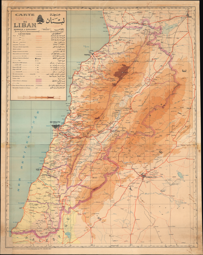
Carte générale du Liban / خريطة لبنان عامة.
1945 (dated) 40 x 31.5 in (101.6 x 80.01 cm) 1 : 200000
1945 (dated) 40 x 31.5 in (101.6 x 80.01 cm) 1 : 200000
Description
This is a 1945 bilingual French-Arabic wall map of Lebanon, prepared by the Service Géographique des Forces Françaises Libres (Geographic Service of Free France). The map captures the final days of the French Mandate World in Lebanon at the end of World War II (1939 - 1945).
In addition to administrative divisions, cities, towns, and villages are indicated in detail, including even small villages of less than one hundred people. Roads and trails of various classes and qualities (including Ancient Roman roads), rail lines, border police posts, points of elevation (elevation also being indicated by shading as seen at the bottom of the legend), and other features are labeled throughout.
With so much in flux, agitation for full independence became louder and more difficult to resist. Bowing to pressure, de Gaulle promised to recognize Lebanon's independence, and elections were held in 1943. One of the new government's first acts was to abolish the French Mandate, which resulted in the French imprisoning the government's leaders and then letting them go due to domestic and international pressure, ensuring Lebanon's independence. As was the case with Syria, due to the war and French reluctance to admit the end of their rule, some French forces remained in the country until 1946.
A Closer Look
The map covers the Lebanese Republic (République Libanaise / الجمهورية اللبنانية), a French territory until 1943 despite its name, as well as portions of Palestine and Syria. The borders of the republic are traced in strong pink, with internal administrative divisions denoted with narrower pink lines. After World War I (1914 - 1918), the French, in consultation with local elites, expanded the borders of the Ottoman Mount Lebanon Mutasarrifate (at the expense of Syria) to create Greater Lebanon, which became the Lebanese Republic in 1926. Yet, as can be seen here, the former Mutasarrifate, which stretched from just north of Sidon to just south of Tripoli, excluding Beirut, remained the largest district.In addition to administrative divisions, cities, towns, and villages are indicated in detail, including even small villages of less than one hundred people. Roads and trails of various classes and qualities (including Ancient Roman roads), rail lines, border police posts, points of elevation (elevation also being indicated by shading as seen at the bottom of the legend), and other features are labeled throughout.
Historical Context
After the Fall of France in 1940, Vichy officials aided the Axis war effort in the Middle East, ferrying supplies to the Kingdom of Iraq, which gained German support in its bid for independence from Britain following a coup in April 1941. Fearing Syria and Lebanon were becoming a bridgehead for the Axis in the region, the Allies invaded in June 1941. Although facing surprisingly strong resistance from the Vichy-aligned French forces, the British were able to make steady progress, and Beirut surrendered without a shot on July 12. Free French forces led by Charles de Gaulle occupied Syria and Lebanon and worked to displace Vichy supporters in the administration.With so much in flux, agitation for full independence became louder and more difficult to resist. Bowing to pressure, de Gaulle promised to recognize Lebanon's independence, and elections were held in 1943. One of the new government's first acts was to abolish the French Mandate, which resulted in the French imprisoning the government's leaders and then letting them go due to domestic and international pressure, ensuring Lebanon's independence. As was the case with Syria, due to the war and French reluctance to admit the end of their rule, some French forces remained in the country until 1946.
Publication History and Census
This map was prepared by the Service Féographique des Forces Françaises Libres, wartime successor to the Service Géographique de l'Armée, in December 1945. It was originally issued as two sheets, the meeting point of which is still evident here. The map is noted among the holdings of eleven institutions in the OCLC and is also held by the Hebrew University of Jerusalem.Cartographer
Service Géographique de l'Armée (1887 - Present) was created from the French Dépot de la Guerre in 1887 and was charged with undertaking all the geodesic, topographic, and cartographic needs of the French army during times of peace and war. The Service was divided into five sections: Geodesy, the Levés de précision, topography, cartography, and accounting. The accounting section dealt with the logistical side of running the Service géographique, including the distribution and shipping of its products. More by this mapmaker...
Condition
Good. Backed on archival tissue for stability. Wear along original fold lines. Light soiling. Some staining from earlier adhesive towards margins. Manuscript infill to lower left corner.
References
OCLC 46882161. Map Collection of the Hebrew University of Jerusalem Record ID 9921170848203701.