This item has been sold, but you can get on the Waitlist to be notified if another example becomes available, or purchase a digital scan.
1878 Hetzel City Map or Plan of Leipzig, Germany
Leipzig-hetzel-1878$87.50

Title
Leipzig.
1878 (dated) 20.75 x 21.5 in (52.705 x 54.61 cm) 1 : 7000
1878 (dated) 20.75 x 21.5 in (52.705 x 54.61 cm) 1 : 7000
Description
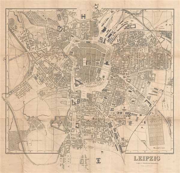
This is an 1878 Hetzel city map or plan of Leipzig, Germany. The map presents the city of Leipzig from the Parthen Strasse and Thüringer Bahnhof to Mottke Strasse and from Frankfurter Strasse to Neu Schönefeld and Neu Reudnitz. A highly detailed depiction, individual buildings are rendered, numerous buildings are labeled, as well as streets and rivers. Several parks are labeled. Four different train stations appear on the map. Forests are included and trees line many of the streets. The Neues Theaten and the Museum are clearly depicted on Augustus Platz.
This map was drawn by G. Hetzel, with additions by W. Rentsch and engraved by Wilhelm Brückner. The map was printed by J. G. Fritzsche and published by J. C. Hinrich'sche Buchhandlung in Leipzig, a prolific publishing firm. The vast majority of their publishing archive burned in the bombing raid on Leipizig in early December 1943.
This map was drawn by G. Hetzel, with additions by W. Rentsch and engraved by Wilhelm Brückner. The map was printed by J. G. Fritzsche and published by J. C. Hinrich'sche Buchhandlung in Leipzig, a prolific publishing firm. The vast majority of their publishing archive burned in the bombing raid on Leipizig in early December 1943.
Condition
Very good. Wear along original fold lines. Even overall toning. Backed on archival tissue for stability.
References
OCLC 316450468.