This item has been sold, but you can get on the Waitlist to be notified if another example becomes available, or purchase a digital scan.
1700 Schenk and Valk Map of the Lesser Antilles
LesserAntilles-schenk-1700$550.00

Title
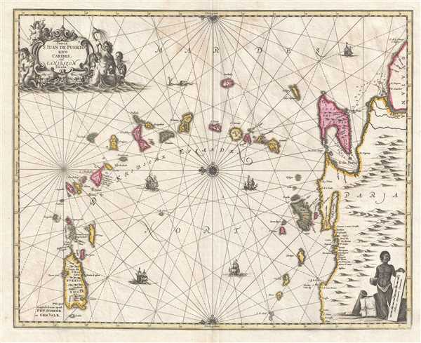
Insula S. Juan de Puerto Rico Caribes; Vel Canibasum Insulae.
1700 (undated) 16.25 x 20.5 in (41.275 x 52.07 cm) 1 : 2630400
1700 (undated) 16.25 x 20.5 in (41.275 x 52.07 cm) 1 : 2630400
Description
This is an attractive c. 1700 map of the Lesser Antilles by Petrus Schenk and Gerard Valk based on a 1650 map by Jan Jansson. Oriented toward the east, the map depicts the region from Puerto Rico to Venezuela and from the Atlantic Ocean and Barbados to Puerto Rico. Beautifully engraved, each island is labeled and shaded a different color. Some of the illustrated islands include the Virgin Islands, Antigua, Guadeloupe, Martinique, Dominica, Montserrat, and St. Lucia. The northern coast of South America is situated along the right border, with a mountain range illustrated in profile, and the mouth of the Orinoco River is also illustrated, complete with depth soundings. Large, two-masted sailing vessels ply the waters of the Caribbean and the Atlantic, and a sea monster is illustrated to the left of Barbados. A beautiful compass rose occupies the map's center, along with a decorative title cartouche situated in the upper left corner flanked by merpeople and sea monsters, and a figure, presumably a slave, holding the scale cartouche in the lower right corner.
This map was issued by Petrus Schenk and Gerard Valk c. 1700.
This map was issued by Petrus Schenk and Gerard Valk c. 1700.
CartographerS
Petrus Schenk (Pieter Schenck) the Elder (December 26, 1660 - 1711) was a Dutch engraver, globe maker, and map publisher active in Amsterdam and Leipzig in the latter half of the 17th century. Schenk, was born in Elberfield, Germany. He moved in Amsterdam in 1675, becoming the apprentice to Gerard Valk (Valck). In 1687, Schenk married Agatha Valk, Gerard Valk's sister and went into partnership with his brother-in-law under the imprint of 'Valk and Schenk'. Initially they focused on maps and atlases, acquiring the map plates of Jan Jansson and Jodocus Hondius in 1694. Later, in 1701 they moved into the former Hondius offices where they began producing globes. Valk and Schenk quickly became known for producing the best globes in the Netherlands, a business on which they held a near monopoly for nearly 50 years. Schenk's three sons, Pieter Schenk the Younger, Jan Schenk, and Leonard Schenk, all became engravers in their own right. Pieter Schenk the Younger inherited the business and ran his father's shop in Leipzig. His daughter, Maria Schenk, married Leonard Valk, the son of Gerard Valk, and continued to run the Valk and Schenk map engraving workshop in Amsterdam. More by this mapmaker...
Gerard Valk (September 30, 1652 - October 21, 1726) (aka. Valck, Walck, Valcke), was a Dutch engraver, globe maker, and map publisher active in Amsterdam in the latter half of the 17th century and early 18th century. Valk was born in Amsterdam where his father, Leendert Gerritsz, was a silversmith. He studied mathematics, navigation, and cartography under Pieter Maasz Smit. Valk and moved to London in 1673, where he studied engraving under Abraham Blooteling (or Bloteling) (1634 - 1690), whose sister he married, and later worked for the map sellers Christopher Browne and David Loggan. Valke and Blooteling returned to Amsterdam in 1680 and applied for a 15-year privilege, a kind of early copyright, from the States General, which was granted in 1684. In 1687, he established his own firm in Amsterdam in partnership with Petrus (Pieter) Schenk, who had just married his sister, Agata. They published under the imprint of Valk and Schenk. Also, curiously in the same year Valk acquired the home of Jochem Bormeester, also engraver and son-in-law of art dealer Clement De Jonghe. Initially Valk and Schenk focused on maps and atlases, acquiring the map plates of Jodocus Hondius and Jan Jansson in 1694. Later, in 1701 they moved into the former Hendrick Hondius (the younger) offices where they began producing globes. Valk and Schenk soon acquired the reputation of producing the finest globes in the Netherlands, a business on which they held a near monopoly for nearly 50 years. In 1702, Valk joined the Bookseller's Guild of which he was promptly elected head. Around the same time, Gerard introduced his son, Leonard, who was married to Maria Schenk, to the business. Leonard spearheaded the acquisition of the map plates of Frederick de Wit in 1709. Nonetheless, Leonard was nowhere near as sophisticated a cartographer or businessman as his father and ultimately, through neglect, lost much the firm's prestige. After his death, the firm was taken over by his widow Maria. Learn More...
Condition
Very good. Even overall toning. Light wear along original centerfold. Area of reinforcement on verso. Blank on verso.