This item has been sold, but you can get on the Waitlist to be notified if another example becomes available, or purchase a digital scan.
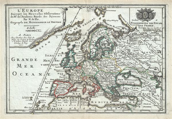
1700 De Fer Map of Europe
LEurope-defer-1700$100.00

Title
L'Europe.
1700 (dated) 9.5 x 13.5 in (24.13 x 34.29 cm) 1 : 26500000
1700 (dated) 9.5 x 13.5 in (24.13 x 34.29 cm) 1 : 26500000
Description
This is a beautiful 1700 map of Europe by Nicholas De Fer. It covers the entire continent including Iceland and the northern coast of Africa, Asia Minor and parts of the Middle East. The map renders the entire region in extraordinary detail offering both topographical and political information with mountains beautifully rendered in profile. The map follows early French cartographers with the prime meridian running through the Isle de Fer (El Hierro), the farthest and southernmost of the Canary Islands. In 1634, King Louis XIII decided that the prime meridian should run through this island, since according to Ptolemy, it was considered the westernmost point of the Old World. This map was created by Nicholas De Fer for his 1701 Atlas.
Cartographer
Nicholas de Fer (1646 - October 25, 1720) was a French cartographer and publisher, the son of cartographer Antoine de Fer. He apprenticed with the Paris engraver Louis Spirinx, producing his first map, of the Canal du Midi, at 23. When his father died in June of 1673 he took over the family engraving business and established himself on Quai de L'Horloge, Paris, as an engraver, cartographer, and map publisher. De Fer was a prolific cartographer with over 600 maps and atlases to his credit. De Fer's work, though replete with geographical errors, earned a large following because of its considerable decorative appeal. In the late 17th century, De Fer's fame culminated in his appointment as Geographe de le Dauphin, a position that offered him unprecedented access to the most up to date cartographic information. This was a partner position to another simultaneously held by the more scientific geographer Guillaume De L'Isle, Premier Geograph de Roi. Despite very different cartographic approaches, De L'Isle and De Fer seem to have stepped carefully around one another and were rarely publicly at odds. Upon his death of old age in 1720, Nicolas was succeeded by two of his sons-in-law, who also happened to be brothers, Guillaume Danet (who had married his daughter Marguerite-Geneviève De Fer), and Jacques-François Bénard (Besnard) Danet (husband of Marie-Anne De Fer), and their heirs, who continued to publish under the De Fer imprint until about 1760. It is of note that part of the De Fer legacy also passed to the engraver Remi Rircher, who married De Fer's third daughter, but Richer had little interest in the business and sold his share to the Danet brothers in 1721. More by this mapmaker...
Source
Fer, Nicholas de, Cartes et Descriptions Generales et Particulieres pour l'intelligence des affaires du temps, au sujet de la Succession de la Couronne d'Espagne, en Europe, en Asie, Afrique, et Amerique, (Paris) 1701.
Condition
Very good. Minor wear along original centerfold. Original platemark visible.
References
Rumsey 2900.003 (1717 edition).