This item has been sold, but you can get on the Waitlist to be notified if another example becomes available, or purchase a digital scan.
1814 Lewis Map of Lewis and Clark Expedition, 1870 Reprint
LewisClarkTrack-lewis-1870$1,000.00

Title
Map of Lewis and Clark's Track, Across the Western Portion of North America..
1870 (undated) 11.75 x 27 in (29.845 x 68.58 cm) 1 : 4300000
1870 (undated) 11.75 x 27 in (29.845 x 68.58 cm) 1 : 4300000
Description
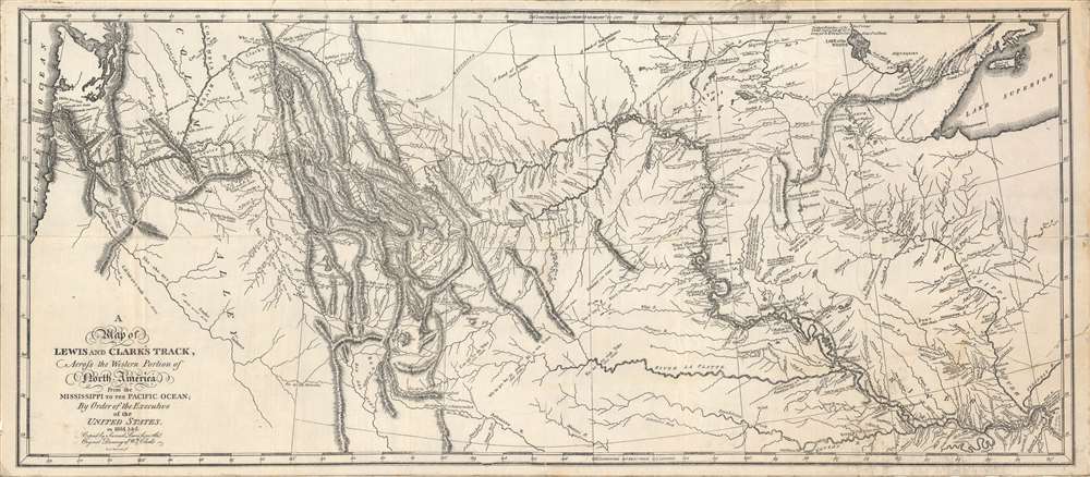
Among the most important maps in American history, this depiction of the Lewis and Clark Expedition completely changed Americans' understanding of the central and western part of the continent. Based on the sketches of William Clark, this is a c. 1870 reprint of the 1814 original map drafted by Samuel Lewis and engraved by Samuel Harrison, for inclusion in the History of the expedition under the command of Captains Lewis and Clark to the sources of the Missouri….
St. Louis is present in the bottom-right corner. A sparsely populated trading post and farming village, it had been beyond the clear authority of any European government since its founding in the 1760s, with the British, French, and Spanish variously claiming or exercising control. The dispute was only settled when Spain transferred the unprofitable Louisiana Territory, including St. Louis, to France, which then promptly sold it to the United States. The transition was so fast that Spanish administrators remained in St. Louis until early 1804, when the U.S. could fully accept a transfer of authority.
The expedition traveled up the Missouri and Columbia Rivers, reaching the Pacific Ocean in early November 1805, and returning to St. Louis in late September 1806. Remarkably, only one member of the expedition died. Aside from areas the expedition traversed, Clark relied on information from Native Americans, and on his own inference, which proved to generally be quite accurate, to produce this map.
Despite copious notes and sketches, the publication of the official account of Lewis and Clark's expedition was delayed for years, as both men were appointed to official positions in the new Louisiana Territory (Lewis as territorial Governor and Clark as Superintendent of Indian Affairs). In September 1809, Lewis, who was engaged in a long-running dispute over payments with the government, died suddenly, likely by suicide. These factors, in addition to the War of 1812, delayed the publication of their account, which included the present map.
Although British and French fur traders, American frontiersmen, and Spanish explorers had covered some of the ground explored by Lewis and Clark, none had traveled the entire course of the Missouri and Columbia Rivers or left anything like the detailed account and map that was presented in 1814. It would be fair to call this one of the most influential maps of America ever produced.
Several manuscript maps were produced in the years following the expedition's conclusion by Nicholas King and Robert Frazier for the government (held by the Library of Congress, Department of State, and the Boston Athenaeum), based on information from the expedition. Clark also produced a manuscript map around 1810 or 1811, held by Yale University, that might have been the basis for Samuel Lewis' engraving (a reduced version is held by the Newberry Library). But the present map was the most complete, legible, and certainly the most widely available map produced in the wake of the Lewis and Clark Expedition.
In addition to the first printing of the map in Philadelphia, printings in 1814, 1815, and 1817 in London were undertaken by Longman, Hurst, Rees, Orme and Brown, distinguished by the addition of 'Neele' as an engraver at bottom-right among other differences, while the American Philosophical Society used the original plate to publish a special run of 150 copies of the map (Rumsey 10052.001), distinguished by number 'x/150' at bottom-right. Afterwards, various reprints were undertaken throughout the 19th and 20th century. Confusing matters further, as not all copies of the History of the expedition included this map, buyers would sometimes buy a separate print of the 1814 original to include with their copy of the text.
The present map most closely resembles the original 1814 Philadelphia printing. However, some subtle differences, such as the lack of a dot below and to the left of the 'N' in North America in the title (similar to the one below the 'r') and the lack of a small circle outside the neatline at bottom between 91 and 92 degrees, demonstrate that it is not identical. Hachures and other fine lines here also lack the crispness of the original copperplate printing, especially evident around 'Royal or Mmong I.' (Isle Royal) in Lake Superior at top-right. At the same time, the paper, backing, and wear are consistent with a date in the 19th century. Therefore, this appears to be a lithographic reissue of the original 1814 engraving, done in the decades following the map's initial publication, perhaps privately issued to complete a first edition that lacked the map.
A Closer Look
True to the title, the tracks of the expedition and places where it camped are noted, along with trading posts of the Northwest Company and Native American villages. Native American groups are carefully cataloged, along with roughly how many members ('souls') they included. The names of many places first appeared in print on this map, sometimes in spellings that were later modified. Longitude is given both from Washington D.C. (at top) and from London (at bottom).St. Louis is present in the bottom-right corner. A sparsely populated trading post and farming village, it had been beyond the clear authority of any European government since its founding in the 1760s, with the British, French, and Spanish variously claiming or exercising control. The dispute was only settled when Spain transferred the unprofitable Louisiana Territory, including St. Louis, to France, which then promptly sold it to the United States. The transition was so fast that Spanish administrators remained in St. Louis until early 1804, when the U.S. could fully accept a transfer of authority.
A Momentous Map
This map radically altered the understanding of the American West. The continent proved much wider than previously thought (the Columbia was mistakenly believed to be a small coastal stream), the Rocky Mountains much higher and more prominent (and distinct from the Cascades), and apocryphal lakes and rivers like the Buenaventura were proven fictitious, along with notions of a Northwest Passage through the American continent. Although some mapmakers continued to include the mythical bodies of water for some time, most in North America and Europe quickly ditched earlier geographies in favor of Lewis and Clark's map.The Lewis and Clark Expedition
In May 1804, Meriwether Lewis and William Clark set out with thirty men on an expedition to explore the lands of the recently acquired Louisiana Purchase, and, more discreetly, to lay the basis for American claims to the Pacific Northwest. Both men were born in Virginia but moved to the frontier (Georgia and Kentucky, respectively) in their youth, where they gained experience interacting with Native Americans. Lewis had social connections to Thomas Jefferson and was known as something of an expert on Indian and frontier affairs, making him a prime candidate to lead the expedition; he then hand-picked Clark to lead the expedition with him. Among the division of labor in leading the enterprise, Clark was tasked with preparing maps.The expedition traveled up the Missouri and Columbia Rivers, reaching the Pacific Ocean in early November 1805, and returning to St. Louis in late September 1806. Remarkably, only one member of the expedition died. Aside from areas the expedition traversed, Clark relied on information from Native Americans, and on his own inference, which proved to generally be quite accurate, to produce this map.
Despite copious notes and sketches, the publication of the official account of Lewis and Clark's expedition was delayed for years, as both men were appointed to official positions in the new Louisiana Territory (Lewis as territorial Governor and Clark as Superintendent of Indian Affairs). In September 1809, Lewis, who was engaged in a long-running dispute over payments with the government, died suddenly, likely by suicide. These factors, in addition to the War of 1812, delayed the publication of their account, which included the present map.
Although British and French fur traders, American frontiersmen, and Spanish explorers had covered some of the ground explored by Lewis and Clark, none had traveled the entire course of the Missouri and Columbia Rivers or left anything like the detailed account and map that was presented in 1814. It would be fair to call this one of the most influential maps of America ever produced.
Publication History and Census
This map was prepared by Samuel Lewis (no relation to Meriwether) using a sketch by William Clark and engraved by Samuel Harrison. It was published in 1814 in Philadelphia as part of Nicholas Biddle and Paul Allen's History of the expedition under the command of Captains Lewis and Clark to the sources of the Missouri… (based on notes and sketches of Lewis and Clark).Several manuscript maps were produced in the years following the expedition's conclusion by Nicholas King and Robert Frazier for the government (held by the Library of Congress, Department of State, and the Boston Athenaeum), based on information from the expedition. Clark also produced a manuscript map around 1810 or 1811, held by Yale University, that might have been the basis for Samuel Lewis' engraving (a reduced version is held by the Newberry Library). But the present map was the most complete, legible, and certainly the most widely available map produced in the wake of the Lewis and Clark Expedition.
In addition to the first printing of the map in Philadelphia, printings in 1814, 1815, and 1817 in London were undertaken by Longman, Hurst, Rees, Orme and Brown, distinguished by the addition of 'Neele' as an engraver at bottom-right among other differences, while the American Philosophical Society used the original plate to publish a special run of 150 copies of the map (Rumsey 10052.001), distinguished by number 'x/150' at bottom-right. Afterwards, various reprints were undertaken throughout the 19th and 20th century. Confusing matters further, as not all copies of the History of the expedition included this map, buyers would sometimes buy a separate print of the 1814 original to include with their copy of the text.
The present map most closely resembles the original 1814 Philadelphia printing. However, some subtle differences, such as the lack of a dot below and to the left of the 'N' in North America in the title (similar to the one below the 'r') and the lack of a small circle outside the neatline at bottom between 91 and 92 degrees, demonstrate that it is not identical. Hachures and other fine lines here also lack the crispness of the original copperplate printing, especially evident around 'Royal or Mmong I.' (Isle Royal) in Lake Superior at top-right. At the same time, the paper, backing, and wear are consistent with a date in the 19th century. Therefore, this appears to be a lithographic reissue of the original 1814 engraving, done in the decades following the map's initial publication, perhaps privately issued to complete a first edition that lacked the map.
Cartographer
Samuel Lewis (c. 1754 - 1822) was an American engraver, cartographer, draftsman, and geographer active in Philadelphia in the first of the 19th century. Though is place of birth is uncertain, most agree that Lewis emigrated from Dublin, Ireland, in the late 18th century. Lewis' earliest cartography work was produced in partnership with the well-known Philadelphia publishers Matthew Carey and Henry Schenk Tanner. In 1804, with the intention of republishing high quality English maps in the United States, Lewis partnered with the eminent British map publisher Arron Arrowsmith. Their first joint publication was A New and Elegant General Atlas, but many others followed including an American edition of Arrowsmith's important double hemisphere wall map of the world. Arrowsmith also worked with Jedidiah Morse, among other important American cartographers of the period. Ralph Brown considers Lewis to be "the most enterprising commercial map-maker of the period … " Lewis is best known for his map related to the expedition of Meriwether Lewis (no relation) and William Clark. In 1814 Lewis, copying directly from William Clark's manuscript, issued A Map of Lewis and Clark's Tracks across the Western Portion of North America. This important document was the first published map derived from the Lewis and Clark Expedition and profoundly transformed the cartography of the American northwest. Samuel Lewis of Philadelphia should not be confused with Samuel Lewis of London, another cartographer active during roughly the same period. More by this mapmaker...
Condition
Very good. Laid on old linen, which itself is partially backed with tissue paper. Chipping, creases, and minor tears in the margins. Areas of discoloration at top-right and at right near margin, perhaps due to pencil marks. Wear along fold lines.
References
Rumsey 3493.001. OCLC 5707855, 865060932. Wheat, C. Mapping the American West, 1540 -1857, Volume I (Mansfield Centre, CT: Martino Publishing, 2014), p. 56 - 60. Cohen, Paul E., Mapping the West: America's Westward Movement, 1524 - 1890 (Rizzoli, 2002), p. 94 - 96.