This item has been sold, but you can get on the Waitlist to be notified if another example becomes available, or purchase a digital scan.
1853 William Lynch Map and Chart of Liberia
Liberia-lynch-1853$700.00

Title
Republic of Liberia.
1853 (undated) 28.25 x 48.5 in (71.755 x 123.19 cm) 1 : 485000
1853 (undated) 28.25 x 48.5 in (71.755 x 123.19 cm) 1 : 485000
Description
This is a rare 1853 map of Liberia produced soon after its independence (1847) by William F. Lynch, an officer in the U.S. Navy who led a mission to West Africa to explore locations for further colonization sites for free people of color. It shows detailed information on the coastline and settlements of Liberia, including the tracts of coastal land purchased by the American Colonization Society (ACS) and independent Liberia since 1822.
The American Colonization Society (ACS) was formally established in 1816 to pursue this goal. In 1818, the ACS sent representatives to West Africa to find a suitable location for a colony, settling on the 'Pepper Coast' just south of Sierra Leone (which since the 1790s was home to a community of African-American colonists, most of whom were 'Black Loyalists' from the American Revolution who sided with the British to gain their freedom). However, the ACS was initially unable to persuade local tribal leaders to grant or sell territory. Nonetheless, plans for the colony progressed and in 1819 the ACS received 100,000 USD from Congress. On February 6, 1820, the first ship, the Elizabeth, sailed from New York to West Africa with 3 ACS agents and 88 African-American emigrants. In 1821, with support of the U.S. Navy, the colonists were finally able to secure a strip of land where Monrovia now stands.
While constantly harassed by the local tribal peoples and decimated by disease (a majority of early arrivals in the colony perished within a couple years), a steady influx of emigrants from America continued to grow the colony. Jehudi Ashmun, an early leader of the ACS, traveled extensively throughout the region in 1825 and 1826, leasing, annexing, or buying tribal lands along the coast and major rivers leading inland (although Ashmun was white, other early leaders of the ACS such as Paul Cuffe and Elijah Johnson were African-Americans). Ashmun also helped to draft the Liberian constitution, which was based upon the U.S. Constitution, but with provisions that granted Americo-Liberians political power over indigenous peoples - power that they retained well into the 20th century. Liberia, although initially conceived as part of an American Empire, declared independence from the United States and the American Colonization Society in 1847.
It is worth noting that most prominent free people of color in the U.S. were deeply opposed to the Liberia scheme, even those like Martin Delany who favored a newly-established country for free people of color. The goals of the ACS were at once racist and imperialistic. They believed that through the promotion of 'democracy' as a core virtue, they would expand the suasive sphere of American culture and trade into the 'primitive' African continent. Ashmun and the other leaders of the ACS movement in Liberia imagined the colony as an agricultural powerhouse from which the natural resources and tribal peoples of Africa could be harnessed for American interests by the same free people of color and former slaves who had been largely rejected and rebuffed by 'white' American society. Moreover, there was a perverse incentive for ACS supporters (including Abraham Lincoln) to further deprive African-Americans of political rights to placate white Americans and encourage further colonization.
A Closer Look
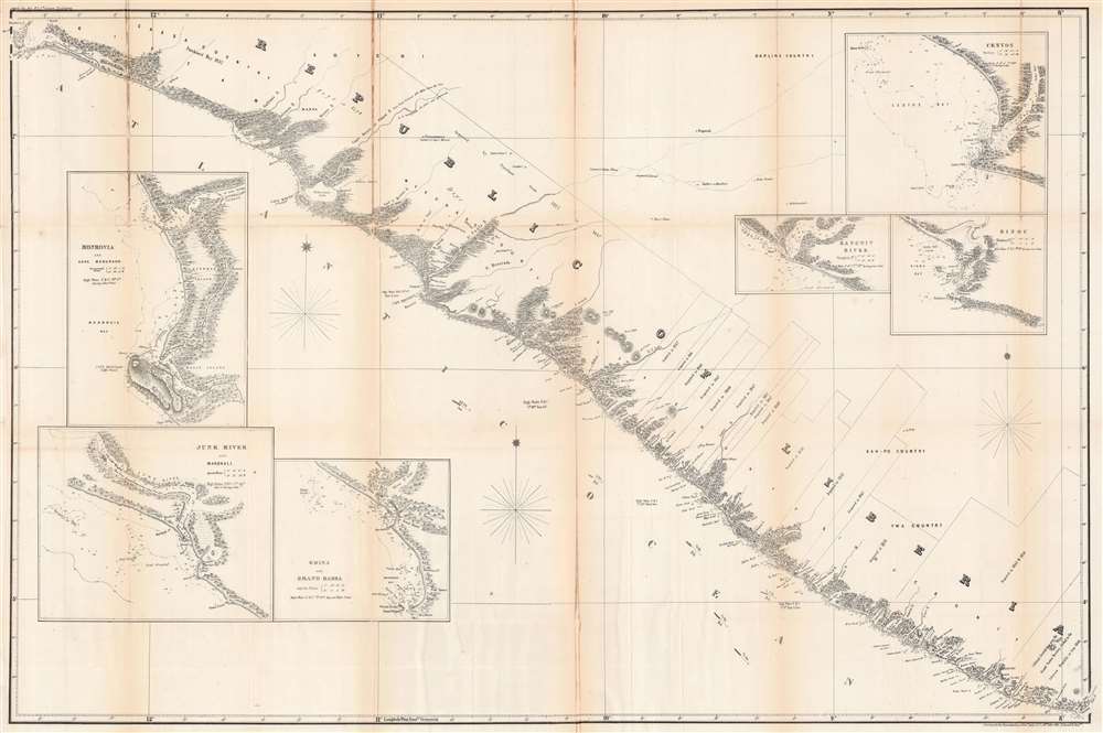
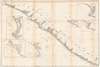
This is both a map of Liberia, which, as can be seen, was confined to within 100 miles of the Atlantic coast, and chart of the coast. On the land side, rivers, hills, mountains, forests, and settlements are indicated, and boxes mark out areas acquired for the colony (later republic) and their dates of acquisition. Some rudimentary information about peoples beyond the borders of the republic in 'Barline Country' is included. On the water, soundings are provided all along the coast and information about high tide and the speed of winds are noted. Six insets are provided, showing: Monrovia and Cape Musurado, the Junk River and Marshall, Edina and Grand Bassa, Cestos, the Sangwin River, and Sinou.Liberia and the American Colonization Society
The settlement of freed slaves and free people of color in Africa became a popular if controversial trend among abolitionists on both sides of the Atlantic in the early 18th century. Feeling that the abolition of slavery and the granting of political rights to formerly enslaved people was politically impossible, colonization appeared to offer abolitionists a neat solution palatable to the white American public. Some free people of color also favored colonization as a solution to the continued harassment and denial of rights they faced in America. Thus, the concept of colonies on the African continent for African-Americans was born.The American Colonization Society (ACS) was formally established in 1816 to pursue this goal. In 1818, the ACS sent representatives to West Africa to find a suitable location for a colony, settling on the 'Pepper Coast' just south of Sierra Leone (which since the 1790s was home to a community of African-American colonists, most of whom were 'Black Loyalists' from the American Revolution who sided with the British to gain their freedom). However, the ACS was initially unable to persuade local tribal leaders to grant or sell territory. Nonetheless, plans for the colony progressed and in 1819 the ACS received 100,000 USD from Congress. On February 6, 1820, the first ship, the Elizabeth, sailed from New York to West Africa with 3 ACS agents and 88 African-American emigrants. In 1821, with support of the U.S. Navy, the colonists were finally able to secure a strip of land where Monrovia now stands.
While constantly harassed by the local tribal peoples and decimated by disease (a majority of early arrivals in the colony perished within a couple years), a steady influx of emigrants from America continued to grow the colony. Jehudi Ashmun, an early leader of the ACS, traveled extensively throughout the region in 1825 and 1826, leasing, annexing, or buying tribal lands along the coast and major rivers leading inland (although Ashmun was white, other early leaders of the ACS such as Paul Cuffe and Elijah Johnson were African-Americans). Ashmun also helped to draft the Liberian constitution, which was based upon the U.S. Constitution, but with provisions that granted Americo-Liberians political power over indigenous peoples - power that they retained well into the 20th century. Liberia, although initially conceived as part of an American Empire, declared independence from the United States and the American Colonization Society in 1847.
It is worth noting that most prominent free people of color in the U.S. were deeply opposed to the Liberia scheme, even those like Martin Delany who favored a newly-established country for free people of color. The goals of the ACS were at once racist and imperialistic. They believed that through the promotion of 'democracy' as a core virtue, they would expand the suasive sphere of American culture and trade into the 'primitive' African continent. Ashmun and the other leaders of the ACS movement in Liberia imagined the colony as an agricultural powerhouse from which the natural resources and tribal peoples of Africa could be harnessed for American interests by the same free people of color and former slaves who had been largely rejected and rebuffed by 'white' American society. Moreover, there was a perverse incentive for ACS supporters (including Abraham Lincoln) to further deprive African-Americans of political rights to placate white Americans and encourage further colonization.
Publication History and Census
This map was one of several that accompanied Commander William F. Lynch's report of his African mission to Congress, published in Message from the president of the United States to the two houses of Congress… at the commencement of the 33rd Congress in 1853. Lynch's report was later published separately and sold to the public, with accompanying illustrations but evidently not the maps, which remain quite rare. We note examples of this map being held by the Library of Congress, the New York Public Library, and Pennsylvania State University, while being scarce to the market. The entire fourth volume of the President's message of 1853 (OCLC 19712768) is more widespread, being held by eight institutions, though it is not clear if this or the other maps produced by Lynch are included. Prior to the present map, there were only a handful of maps of Liberia produced in Britain and America, including the earliest one produced by Ashmun and the ACS (https://www.geographicus.com/P/AntiqueMap/liberiamonrovia-ashmun-1830).Cartographer
William F. Lynch (April 1, 1801 – October 17, 1865) was an American naval officer in the mid-19th century who led missions to the Middle East and Africa, producing important maps and information about the River Jordan, Dead Sea, and West African coast. A Virginia native, Lynch joined the Confederate States Navy at the start of the Civil War and saw action commanding naval defenses against Union Navy attacks, including at Vicksburg. He was paroled at the end of the war and died soon afterwards. More by this mapmaker...
Condition
Average. Wear and toning along fold lines, with some loss and verso reinstatement.
References
OCLC 37986391, 37986417.