This item has been sold, but you can get on the Waitlist to be notified if another example becomes available.
1986 Cioca and New York Post Pictorial Map of New York City
LibertyWeekend-cioca-1986$225.00

Title
Liberty Weekend July 3 - July 6 '86.
1986 (dated) 22.5 x 14.5 in (57.15 x 36.83 cm)
1986 (dated) 22.5 x 14.5 in (57.15 x 36.83 cm)
Description
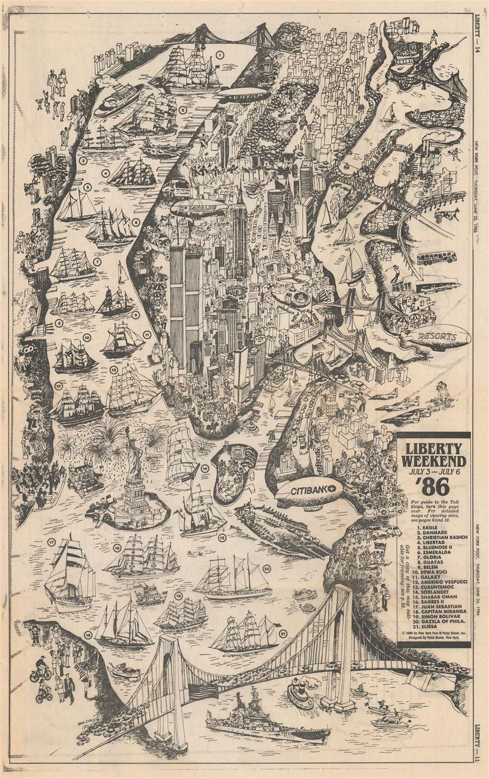
This is a 1986 Dan Cioca pictorial map of New York City celebrating Liberty Weekend. Liberty Weekend took place between July 3, 1986 and July 6, 1986 and celebrated the 1984 renovation and centenary of the Statue of Liberty. The Statue of Liberty is prominently illustrated surrounded by bursting fireworks. The World Trade Center, the Empire State Building, the Chrysler Building, Rockefeller Center, Lincoln Center, and the Metropolitan Museum of Art are all identifiable. New York's iconic bridges also hold prominent places, with the Brooklyn Bridge, Manhattan Bridge, and Queensboro crossing the East River between Manhattan and Brooklyn. The Verrazzano-Narrows Bridge appears prominently in the foreground.
Liberty Weekend Events
The map also illustrates many of Liberty Weekend's events, including the Parade of Tall Ships down the Hudson River, known as 'Operation Sail'. It was the largest flotilla of tall ships assembled in modern history and included twenty-one tall ships from across the world. President Reagan watched the parade from the USS Iowa, and indeed an Iowa-class battleship illustrated here in the foreground beneath the Verrazzano-Narrows Bridge. Four blimps appear above the city, all of which participated in the 'Great Blimp Race' down the Hudson River from the George Washington Bridge to Battery Park. The Fuji blimp won the race. Other illustrated events include the ceremony of Governor's Island, the citizenship event at Ellis Island, and the Boston Pops Orchestra concert conducted by John Williams at Liberty State Park in New Jersey.Publication History and Census
This map was drawn by Dan Cioca, designed by Point Blank Inc., and published by the New York Post on Thursday, June 26, 1986. We have seen no other examples of the present map and it is not cataloged in OCLC.Cartographer
Dan Cioca (b. 1939) is a Polish artist who was active in New York City. He published a map in the New York Post on June 26, 1986 celebrating Liberty Weekend, the centennial of the Statue of Liberty. More by this mapmaker...
Condition
Very good. Newsprint. Closed margin tears professionally repaired on verso. Text and printed images on verso.