This item has been sold, but you can get on the Waitlist to be notified if another example becomes available, or purchase a digital scan.
1701 De Fer Map of the Lineage and Alliances since Philip I of Castile
Lignedirecte-defer-1701$50.00

Title
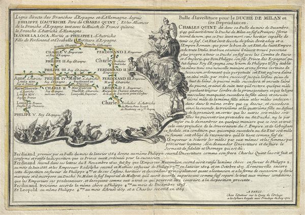
Ligne directe des branches d'Espagne et d'Allemagne depuis Philippe d'Autriche Pere de Charles Quint; Et les Alliances de la Branche d'Espagne tant avec la Maison de France qu'avec la Branche d'Autriche d'Alemagne.
1701 (dated) 9.5 x 13.5 in (24.13 x 34.29 cm)
1701 (dated) 9.5 x 13.5 in (24.13 x 34.29 cm)
Description
This is a fine 1701 map of the lineage of Philip I of Castile. It notes spouses, and children, and succession as well as title and alliances mapping their rule in Spain, France and Austria. The two sons of Philip I went on to rule the Spanish Empire (Charles V) and the Habsburg Empire (Ferdinand I). Philip II inherited the Spanish crown from Charles V which would then pass to his son Philip II and his grandson Philip III and so forth. It goes on to map the ancestry of Philip V of Spain and Charle, Archduke of Austria. The family tree or pedigree chart, in the top left quadrant is surrounded by a beautifully illustrated cartouche, while detailed information is included in the right and lower parts of the sheet. This map was issued by Nicholas De Fer in his 1701 Atlas.
Cartographer
Nicholas de Fer (1646 - October 25, 1720) was a French cartographer and publisher, the son of cartographer Antoine de Fer. He apprenticed with the Paris engraver Louis Spirinx, producing his first map, of the Canal du Midi, at 23. When his father died in June of 1673 he took over the family engraving business and established himself on Quai de L'Horloge, Paris, as an engraver, cartographer, and map publisher. De Fer was a prolific cartographer with over 600 maps and atlases to his credit. De Fer's work, though replete with geographical errors, earned a large following because of its considerable decorative appeal. In the late 17th century, De Fer's fame culminated in his appointment as Geographe de le Dauphin, a position that offered him unprecedented access to the most up to date cartographic information. This was a partner position to another simultaneously held by the more scientific geographer Guillaume De L'Isle, Premier Geograph de Roi. Despite very different cartographic approaches, De L'Isle and De Fer seem to have stepped carefully around one another and were rarely publicly at odds. Upon his death of old age in 1720, Nicolas was succeeded by two of his sons-in-law, who also happened to be brothers, Guillaume Danet (who had married his daughter Marguerite-Geneviève De Fer), and Jacques-François Bénard (Besnard) Danet (husband of Marie-Anne De Fer), and their heirs, who continued to publish under the De Fer imprint until about 1760. It is of note that part of the De Fer legacy also passed to the engraver Remi Rircher, who married De Fer's third daughter, but Richer had little interest in the business and sold his share to the Danet brothers in 1721. More by this mapmaker...
Source
Fer, Nicholas de, Cartes et Descriptions Generales et Particulieres pour l'intelligence des affaires du temps, au sujet de la Succession de la Couronne d'Espagne, en Europe, en Asie, Afrique, et Amerique, (Paris) 1701.
Condition
Very good. Minor wear and verso repair along original centerfold. Original platemark visible.